Nebraska Highway 44
Nebraska Highway 44 (NE‑44) is a 31.51-mile (50.71 km) highway in Franklin, Kearney, and Buffalo counties in Nebraska, United States. It runs in a south-to-north direction from Nebraska Highway 4 (NE‑4) south of Wilcox to an intersection with U.S. Route 30 (US 30) in Kearney.
| ||||
|---|---|---|---|---|
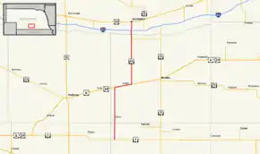 Nebraska Highway 44 highlighted in red | ||||
| Route information | ||||
| Maintained by NDOT | ||||
| Length | 31.51 mi[1] (50.71 km) | |||
| Existed | 1926[2]–present | |||
| Major junctions | ||||
| South end | ||||
| North end | ||||
| Location | ||||
| Counties | Franklin, Kearney, Buffalo | |||
| Highway system | ||||
| ||||

Route description
NE‑44 begins at an intersection with NE‑4 south of Wilcox. It heads through farmland and passes through Wilcox, then meets U.S. Route 6/U.S. Route 6 (US 6/US 34), which are concurrent with each other. NE‑44 then turns east with US 6/US 34 and passes through Axtell. East of Axtell, NE‑44 turns north. Near Kearney, NE‑44 meets Nebraska Link 50A, which serves as a link to Fort Kearny State Historical Park. Shortly after, NE‑44 crosses the Platte River and becomes a divided highway. NE‑44 then enters Kearney and meets Interstate 80. The highway continues north towards downtown Kearney on Second Avenue and ends at an intersection with US 30.[1][3]
Major intersections
| County | Location | mi[1] | km | Destinations | Notes |
|---|---|---|---|---|---|
| Franklin | | 0.00 | 0.00 | Southern terminus; road continues as 21 Road | |
| Kearney | Axtell | 12.47 | 20.07 | Southern end of US 6/US 34 concurrency | |
| 16.55 | 26.63 | Northern end of US 6/US 34 concurrency | |||
| | 27.39 | 44.08 | |||
| Buffalo | Kearney | 29.35 | 47.23 | I-80 Exit 272 | |
| 31.51 | 50.71 | Northern terminus; road continues north as 2nd Avenue, serving CHI Health Good Samaritan Hospital | |||
1.000 mi = 1.609 km; 1.000 km = 0.621 mi
| |||||
See also
References
- "Nebraska Highway Reference Log Book" (PDF). Nebraska Department of Roads. 2015. p. 140. Retrieved January 7, 2017.
- "The Nebraska Highways Page: Highways 31 to 60". Archived from the original on 2007-02-08. Retrieved 2007-10-28.
- Google (2010-11-03). "overview of Nebraska Highway 44" (Map). Google Maps. Google. Retrieved 2010-11-03.