North Platte, Nebraska
North Platte is a city in and the county seat of Lincoln County, Nebraska, United States.[6] It is located in the west-central part of the state, along Interstate 80, at the confluence of the North and South Platte Rivers forming the Platte River. The population was 24,733 at the 2010 census.[7]
North Platte, Nebraska | |
|---|---|
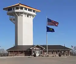 Golden Spike Tower and visitor center at Union Pacific's Bailey Yards | |
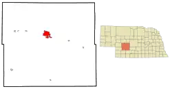 Location of North Platte within Lincoln County and Nebraska | |
| Coordinates: 41.136°N 100.763°W | |
| Country | United States |
| State | Nebraska |
| County | Lincoln |
| Government | |
| • Mayor | Brandon Kelliher[1] |
| Area | |
| • Total | 13.42 sq mi (34.76 km2) |
| • Land | 13.24 sq mi (34.28 km2) |
| • Water | 0.19 sq mi (0.48 km2) |
| Elevation | 2,802 ft (854 m) |
| Population | |
| • Total | 24,733 |
| • Estimate (2019)[4] | 23,639 |
| • Density | 1,785.96/sq mi (689.57/km2) |
| Time zone | UTC−6 (Central (CST)) |
| • Summer (DST) | UTC−5 (CDT) |
| ZIP codes | 69101, 69103 |
| Area code(s) | 308 |
| FIPS code | 31-35000 |
| GNIS feature ID | 0831719[5] |
| Website | www |
North Platte is a railroad town; Union Pacific Railroad's large Bailey Yard is located within the city. Today, North Platte is served only by freight trains, but during World War II the city was famous for the North Platte Canteen. Tens of thousands of volunteers from North Platte and surrounding towns met the troop trains passing through North Platte, offering coffee, sandwiches and hospitality.
North Platte is the principal city of the North Platte Micropolitan Statistical Area, which includes Lincoln, Logan, and McPherson counties.
History
North Platte was established in 1866 when the Union Pacific Railroad was extended to that point.[8] It was named from the North Platte River.[9][10]
On July 13, 1929, black North Platte resident Louis "Slim" Seeman was accused of shooting and killing Edward Green, a North Platte police officer.[11] Following the incident, a mob of white residents of North Platte killed Seeman,[11] then walked through the city, telling black residents to leave North Platte.[12] Fearing mob violence, most of North Platte's black residents fled.[12]
Geography
North Platte is located at 41°8′9″N 100°46′14″W (41.135914, −100.770501).[13] According to the United States Census Bureau, the city has a total area of 13.39 square miles (34.68 km2), of which 13.20 square miles (34.19 km2) is land and 0.19 square miles (0.49 km2) is water.[14]
Climate
North Platte experiences a dry continental climate similar to that of the Nebraska High Plains, classified as humid continental (Köppen Dwa/Dfa), and, with an annual average precipitation of 20.22 inches (514 mm), barely avoids semi-arid classification; it is part of USDA Hardiness zone 5a.[15] The normal monthly mean temperature ranges from 25.0 °F (−3.9 °C) in January to 74.3 °F (23.5 °C) in July.[16] On average, there are 3.5 afternoons that reach 100 °F (37.8 °C) or higher, 37 afternoons that reach 90 °F (32.2 °C) or higher, 33 afternoons that do not climb above freezing, and 13 mornings with a low of 0 °F (−17.8 °C) or below.[16] The average window for freezing temperatures is September 26 thru May 10,[16] allowing a growing season of 138 days. Extreme temperatures officially range from −35 °F (−37.2 °C) on January 15, 1888 and February 12, 1899, up to 112 °F (44.4 °C) on July 11, 1954; the record cold daily maximum is −15 °F (−26.1 °C) on January 14, 1888, while, conversely, the record warm daily minimum is 80 °F (26.7 °C) on July 25, 1940.[16]
Precipitation is greatest in May and June and has ranged from 10.01 inches (254.3 mm) in 1931 to 33.44 inches (849.4 mm) in 1951.[16] Snowfall averages 28.5 inches (0.72 m) per season, and has historically ranged from 3.0 inches (0.08 m) in 1903–04 to 66.3 inches (1.68 m) in 1979–80;[16] the average window for measurable (≥0.1 inches or 0.0025 metres) snowfall is October 30 thru April 11, with May snow being rare.[16]
| Climate data for North Platte Regional Airport, Nebraska (1981-2010 normals,[lower-alpha 1] extremes 1874-present)[lower-alpha 2] | |||||||||||||
|---|---|---|---|---|---|---|---|---|---|---|---|---|---|
| Month | Jan | Feb | Mar | Apr | May | Jun | Jul | Aug | Sep | Oct | Nov | Dec | Year |
| Record high °F (°C) | 74 (23) |
79 (26) |
91 (33) |
98 (37) |
99 (37) |
107 (42) |
112 (44) |
108 (42) |
105 (41) |
96 (36) |
87 (31) |
76 (24) |
112 (44) |
| Mean maximum °F (°C) | 61.6 (16.4) |
67.4 (19.7) |
76.8 (24.9) |
84.9 (29.4) |
89.8 (32.1) |
96.3 (35.7) |
100.8 (38.2) |
98.5 (36.9) |
94.5 (34.7) |
85.1 (29.5) |
73.8 (23.2) |
62.2 (16.8) |
102.4 (39.1) |
| Average high °F (°C) | 38.9 (3.8) |
43.0 (6.1) |
52.5 (11.4) |
62.2 (16.8) |
71.7 (22.1) |
81.8 (27.7) |
88.2 (31.2) |
86.1 (30.1) |
77.8 (25.4) |
64.5 (18.1) |
50.2 (10.1) |
39.1 (3.9) |
63.1 (17.3) |
| Average low °F (°C) | 11.1 (−11.6) |
15.0 (−9.4) |
23.5 (−4.7) |
33.0 (0.6) |
44.1 (6.7) |
54.0 (12.2) |
60.4 (15.8) |
58.2 (14.6) |
46.8 (8.2) |
33.6 (0.9) |
21.0 (−6.1) |
11.6 (−11.3) |
34.5 (1.4) |
| Mean minimum °F (°C) | −7.0 (−21.7) |
−4.8 (−20.4) |
5.7 (−14.6) |
17.2 (−8.2) |
28.6 (−1.9) |
40.7 (4.8) |
48.8 (9.3) |
46.8 (8.2) |
30.0 (−1.1) |
17.0 (−8.3) |
3.5 (−15.8) |
−7.2 (−21.8) |
−16.5 (−26.9) |
| Record low °F (°C) | −35 (−37) |
−35 (−37) |
−25 (−32) |
−3 (−19) |
18 (−8) |
29 (−2) |
39 (4) |
35 (2) |
17 (−8) |
4 (−16) |
−25 (−32) |
−34 (−37) |
−35 (−37) |
| Average precipitation inches (mm) | 0.34 (8.6) |
0.50 (13) |
1.05 (27) |
2.27 (58) |
3.28 (83) |
3.42 (87) |
3.07 (78) |
2.29 (58) |
1.41 (36) |
1.55 (39) |
0.64 (16) |
0.41 (10) |
20.23 (514) |
| Average snowfall inches (cm) | 4.8 (12) |
5.3 (13) |
4.4 (11) |
3.2 (8.1) |
trace | 0 (0) |
0 (0) |
0 (0) |
0.2 (0.51) |
2.1 (5.3) |
3.9 (9.9) |
4.6 (12) |
28.5 (72) |
| Average precipitation days (≥ 0.01 in) | 4.1 | 5.1 | 6.7 | 8.4 | 11.6 | 10.5 | 10.3 | 8.8 | 7.0 | 6.6 | 4.7 | 3.6 | 87.4 |
| Average snowy days (≥ 0.1 in) | 4.2 | 4.1 | 3.9 | 2.0 | 0.1 | 0 | 0 | 0 | 0.2 | 0.7 | 2.5 | 3.5 | 21.2 |
| Average relative humidity (%) | 69.3 | 68.2 | 64.4 | 59.6 | 63.3 | 63.9 | 63.0 | 64.1 | 63.8 | 61.5 | 66.9 | 69.6 | 64.8 |
| Mean monthly sunshine hours | 185.0 | 180.2 | 227.4 | 257.5 | 290.8 | 322.9 | 352.9 | 319.2 | 259.5 | 236.2 | 174.0 | 170.0 | 2,975.6 |
| Percent possible sunshine | 62 | 60 | 61 | 64 | 65 | 71 | 77 | 75 | 69 | 69 | 59 | 59 | 67 |
| Source: NOAA (relative humidity and sun 1961–1990)[16][18][19] | |||||||||||||
Demographics
| Historical population | |||
|---|---|---|---|
| Census | Pop. | %± | |
| 1880 | 363 | — | |
| 1890 | 3,055 | 741.6% | |
| 1900 | 3,640 | 19.1% | |
| 1910 | 4,793 | 31.7% | |
| 1920 | 10,466 | 118.4% | |
| 1930 | 12,061 | 15.2% | |
| 1940 | 12,429 | 3.1% | |
| 1950 | 15,433 | 24.2% | |
| 1960 | 17,184 | 11.3% | |
| 1970 | 19,447 | 13.2% | |
| 1980 | 24,509 | 26.0% | |
| 1990 | 22,605 | −7.8% | |
| 2000 | 23,878 | 5.6% | |
| 2010 | 24,733 | 3.6% | |
| 2019 (est.) | 23,639 | [4] | −4.4% |
| U.S. Decennial Census[20] 2018 Estimate[21] | |||
2010 census
As of the census[3] of 2010, there were 24,733 people, 10,560 households, and 6,290 families residing in the city. The population density was 1,873.7 inhabitants per square mile (723.4/km2). There were 11,450 housing units at an average density of 867.4 per square mile (334.9/km2). The racial makeup of the city was 93.1% White, 1.0% African American, 0.7% Native American, 0.7% Asian, 2.8% from other races, and 1.7% from two or more races. Hispanic or Latino of any race were 8.8% of the population.
There were 10,560 households, of which 30.4% had children under the age of 18 living with them, 44.5% were married couples living together, 10.7% had a female householder with no husband present, 4.3% had a male householder with no wife present, and 40.4% were non-families. 34.8% of all households were made up of individuals, and 13.9% had someone living alone who was 65 years of age or older. The average household size was 2.29 and the average family size was 2.95.
The median age in the city was 37.1 years. 24.9% of residents were under the age of 18; 9% were between the ages of 18 and 24; 25% were from 25 to 44; 25.6% were from 45 to 64; and 15.5% were 65 years of age or older. The gender makeup of the city was 48.8% male and 51.2% female.
2000 census
As of the census of 2000, there were 23,878 people, 9,944 households, and 6,224 families residing in the city. The population density was 2,281.5 people per square mile (880.5/km2). There were 10,718 housing units at an average density of 1,024.1 per square mile (395.2/km2). The racial makeup of the city was 93.47% White, 0.71% African American, 0.64% Native American, 0.39% Asian, 0.03% Pacific Islander, 3.30% from other races, and 1.45% from two or more races. Hispanic or Latino of any race were 6.68% of the population.
There were 9,944 households, out of which 31.0% had children under the age of 18 living with them, 49.8% were married couples living together, 9.6% had a female householder with no husband present, and 37.4% were non-families. 31.9% of all households were made up of individuals, and 13.0% had someone living alone who was 65 years of age or older. The average household size was 2.34 and the average family size was 2.97.
In the city, the population was spread out, with 26.0% under the age of 18, 9.5% from 18 to 24, 26.8% from 25 to 44, 21.9% from 45 to 64, and 15.8% who were 65 years of age or older. The median age was 36 years. For every 100 females, there were 94.5 males. For every 100 females age 18 and over, there were 90.0 males.
As of 2000 the median income for a household in the city was $34,181, and the median income for a family was $42,753. Males had a median income of $36,445 versus $20,157 for females. The per capita income for the city was $18,306. About 7.8% of families and 10.5% of the population were below the poverty line, including 13.2% of those under age 18 and 9.8% of those age 65 or over.
Media
Transportation
North Platte is home to North Platte Regional Airport. United Express serves the airport with twice-daily service to Denver International Airport.
Points of interest
North Platte is home to the world's largest rail yard, Bailey Yard. The Golden Spike Tower and Visitor Center is an eight-story building which overlooks the expansive classification yard and engine facilities. The tower and visitor center are open to the public year-round.[22]
North Platte was the western terminus of the Union Pacific Railway from the summer of 1867 until the next section to Laramie, Wyoming, was opened the following summer. Even though Congress had authorized the building of the Transcontinental Railroad in 1862, it was only extended as far as Nebraska City by the start of the summer of 1867. The 275-mile section from Nebraska City to North Platte was completed in less than six weeks.
Lincoln County Historical Museum contains a display detailing the history of the North Platte Canteen, which greeted 6.5 million service personnel from Christmas Day 1941 through April 1, 1946. It also contains a Prairie Village with local landmark homes and other buildings, including a Pony Express station and pioneer church among many others.[23]
Buffalo Bill Ranch State Historical Park is located near North Platte, a Nebraska living history park about Buffalo Bill Cody. The park includes his actual house known as Scout's Rest Ranch. The park is two miles west of U.S. Highway 83 along U.S. Highway 30.[24]
Every June, North Platte hosts the annual "Nebraskaland Days". The event includes parades, art shows, rodeos, concerts, and food events. It draws over 100,000 attendees every year.[25]
North Platte is host to the annual Miss Nebraska pageant, an official preliminary for the Miss America Organization.[26]
Notable people
- Chris Başak, baseball infielder was born in North Platte. He played in the New York Mets, Minnesota Twins and New York Yankees organizations. He made five appearances in the major leagues in 2007 with the Yankees, going 0-for-1.
- Howard Baskerville, American teacher in the Presbyterian mission school in Tabriz, Iran; born in North Platte. He was killed defensing the Constitutional Revolution of Iran and known as "American Martyr of the Constitutional Revolution."
- Buffalo Bill Cody, iconic Wild West showman, owned a ranch in North Platte.[27]
- Nathan Enderle, football quarterback, selected by the Chicago Bears in the fifth round of the 2011 NFL Draft; born in North Platte and attended North Platte High School.[28]
- Paul Faulkner, artist; born in North Platte.[29]
- Chuck Hagel, Nebraska U.S. Senator and U.S. Secretary of Defense; born in North Platte.[30]
- Bill Hayes, baseball player, lived in North Platte and attended Saint Patrick's High School.
- Henry Hill, New York City mobster; worked as a cook in North Platte.
- John Howell, former American football safety in the National Football League, played for the Tampa Bay Buccaneers and Seattle Seahawks; born in North Platte.[31]
- Glenn Miller, popular big band leader; lived in North Platte for one year during his early childhood.[32]
- Keith Neville, 18th governor of Nebraska; born in North Platte.[33]
- Joe Ragland (born 1989), American-Liberian basketball player for Hapoel Eilat of the Israeli Basketball Premier League
- Red Cloud, Sioux warrior; born near North Platte in 1822.[34]
- Dr. Don Rose, San Francisco Bay Area disc jockey; born and raised in North Platte and frequently referred to the city on his morning show.
- Ryan Schultz, professional mixed martial artist, Lightweight Champion of defunct IFL; raised in North Platte.[35]
- Danny Woodhead, retired NFL running back; born in North Platte and attended North Platte High School.[36]
Local Businesses
Notes
- Mean monthly maxima and minima (i.e. the expected highest and lowest temperature readings at any point during the year or given month) calculated based on data at said location from 1981 to 2010.
- Official records for North Platte kept at downtown from September 1874 to December 1947 and at North Platte Regional Airport since January 1948.[17]
References
- https://nptelegraph.com/news/local/govt-and-politics/brandon-kelliher-wins-north-platte-mayoral-contest/article_ed231560-1e69-11eb-960f-5324d2ccb3d6.html
- "2019 U.S. Gazetteer Files". United States Census Bureau. Retrieved July 26, 2020.
- "U.S. Census website". United States Census Bureau. Retrieved 2012-06-24.
- "Population and Housing Unit Estimates". United States Census Bureau. May 24, 2020. Retrieved May 27, 2020.
- "US Board on Geographic Names". United States Geological Survey. 2007-10-25. Retrieved 2008-01-31.
- "Find a County". National Association of Counties. Retrieved 2011-06-07.
- "Incorporated Places and Minor Civil Divisions: Nebraska". Population Census. 2010 United States Census. 2011-07-18. Retrieved 2011-07-30.
- "North Platte, Lincoln County". Center for Advanced Land Management Information Technologies. University of Nebraska. Retrieved 19 August 2014.
- "Profile for North Platte, NE". ePodunk. Archived from the original on 20 August 2014. Retrieved 19 August 2014.
- Fitzpatrick, Lillian L. (1960). Nebraska Place-Names. University of Nebraska Press. p. 96. ISBN 0-8032-5060-6. A 1925 edition is available for download at University of Nebraska—Lincoln Digital Commons.
- "A History of Racial Injustice – Equal Justice Initiative". racialinjustice.eji.org. Retrieved 31 March 2018.
- "Nebraska State Historical Society" (PDF). Nebraska State Historical Society. Retrieved 31 March 2018.
- "US Gazetteer files: 2010, 2000, and 1990". United States Census Bureau. 2011-02-12. Retrieved 2011-04-23.
- "US Gazetteer files 2010". United States Census Bureau. Archived from the original on 2012-07-02. Retrieved 2012-06-24.
- "USDA Plant Hardiness Zone Map". United States Department of Agriculture. Archived from the original on 2014-02-27. Retrieved 2014-06-01.
- "NowData – NOAA Online Weather Data". National Oceanic and Atmospheric Administration. Retrieved 2020-11-14.
- "Threaded Extremes". threadex.rcc-acis.org. Retrieved 31 March 2018.
- "Station Name: NE NORTH PLATTE RGNL AP". National Oceanic and Atmospheric Administration. Retrieved 2020-07-11.
- "WMO Climate Normals for NORTH PLATTE/LEE BIRD FLD NE 1961–1990". National Oceanic and Atmospheric Administration. Retrieved 2014-03-10.
- United States Census Bureau. "Census of Population and Housing". Retrieved October 16, 2013.
- "Population Estimates". United States Census Bureau. Retrieved June 8, 2018.
- Description from goldenspiketower.com Archived 2009-03-29 at the Wayback Machine. Retrieved on 2009-03-15.
- Description from Lincolncountymuseum.org. Retrieved on 2015-10-23.
- Description from visitnorthplatte.com. Retrieved on 2015-10-23.
- "About Us". Archived 2011-07-14 at the Wayback Machine Nebraskaland Days website. Archived 2011-07-28 at the Wayback Machine Retrieved 2011-07-27.
- "Events". Archived 2016-06-06 at the Wayback Machine VisitNorthPlatte.com. Retrieved May 31, 2016.
- "Buffalo Bill Ranch State Historical Park". Visit North Platte. Retrieved 14 March 2017.
- "Nathan Enderle #4 QB". NFL Enterprises LLC. Retrieved October 22, 2012.
- 'Paul Faulkner-Was NFA artist,The Day (New London, Connecticut, January 6, 1997, B4
- "Biography of Senator Chuck Hagel". Official website of Senator Chuck Hagel. Archived from the original on 2008-05-19. Retrieved 2008-02-20.
- "John Howell". databaseFootball.com. Archived from the original on October 25, 2012. Retrieved October 22, 2012.
- "Sandhill highway to be named after Glenn Miller". McCook Daily Gazette. 1999-09-01. Retrieved 2012-10-22.
- "Nebraska Governor Keith M. Neville". National Governors Association. Retrieved September 29, 2012.
- "Red Cloud". New Perspectives of the West. Retrieved October 22, 2012.
- "Northern Colorado's Premier MMA Gym". Trials Martial Arts and Fitness i. Retrieved October 22, 2012.
- "Danny Woodhead #39 RB". NFL Enterprises LLC. Retrieved October 22, 2012.
- "1st State Bank Locations". 1st.BANK.
Further reading
- Once Upon a Town: The Miracle of the North Platte Canteen<, Bob Greene, Morrow/Avon, 2002, hardcover, 256 pages, ISBN 0-06-008196-1
- North Platte and its associations, Archibald Adamson, The Evening Telegraph, North Platte, NE, 1910, 241 pages, URL https://archive.org/details/northplatteitsas00adam
- Beckius, Jim (2002), North Platte: City Between Two Rivers, Chicago, Illinois: Arcadia
External links
| Wikimedia Commons has media related to North Platte, Nebraska. |
- City of North Platte
- North Platte Area Chamber of Commerce
- North Platte Lincoln County Convention and Visitors Bureau
 North Platte travel guide from Wikivoyage
Municipalities and communities of Lincoln County, Nebraska, United States | ||
|---|---|---|
| City | Map of Nebraska highlighting Lincoln County | |
| Villages | ||
| Unincorporated communities | ||
| ||

| Authority control |
|---|