U.S. Route 6 in Nebraska
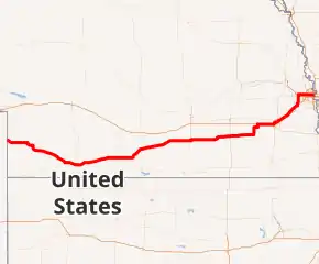
U.S. Highway 6 (US 6) in the U.S. state of Nebraska is a highway which goes from the Colorado border west of Imperial in the west to the Iowa border in the east at Omaha. Significant portions of the highway are concurrent with other highways, most significantly, U.S. Highway 34 between Culbertson and Hastings. Also, from Milford east to the Iowa border, the highway is closely paralleled by Interstate 80. Large portions of the route parallel the Chicago, Burlington and Quincy Railroad.
| ||||
|---|---|---|---|---|
US 6 highlighted in red | ||||
| Route information | ||||
| Maintained by NDOT | ||||
| Length | 373.00 mi[1] (600.29 km) | |||
| Existed | 1931–present | |||
| Major junctions | ||||
| West end | ||||
| East end | ||||
| Location | ||||
| Counties | Chase, Hayes, Hitchcock, Red Willow, Furnas, Harlan, Phelps, Kearney, Adams, Clay, Fillmore, Saline, Seward, Lancaster, Cass, Saunders, Sarpy, Douglas | |||
| Highway system | ||||
| ||||

Route description

U.S. Highway 6 enters Nebraska from Colorado west of Imperial on a short southeasterly segment. It turns east and stays due east until shortly before Imperial. It then goes into Imperial and meets Nebraska Highway 61. The two routes are paired together until they separate at the Enders Reservoir State Recreation Area. It goes in a generally southeasterly direction until it meets U.S. Highway 34 west of Culbertson.[1][2]
US 6 and US 34 continue east together through Culbertson and at McCook, is briefly concurrent with U.S. Highway 83. US 6/34 continue together in a northeasterly direction through Cambridge, then turns due east and meets U.S. Highway 283 in Arapahoe. Near Edison, it meets U.S. Highway 136, which begins at its intersection with US 6/34. Further east, the two highways meet Nebraska Highway 4 and turns northeast towards Holdrege, Nebraska. In Holdrege, US 6/34 meet U.S. Highway 183. The highways continue on a northeasterly trajectory through Minden until Heartwell. At Heartwell, US 6/34 turns due east until Hastings. In Hastings, US 6/34 meet U.S. Highway 281 and US 34 separates to go with US 281 while US 6 continues eastward.[1][2]
US 6 continues on a due east highway from Hastings. Near Sutton, the highway turns northeast to go through Sutton. It continues east and at Fairmont, US 6 encounters U.S. Highway 81. After passing through Friend, US 6 meets Nebraska Highway 15 and the two highways overlap until shortly before Milford. US 6 goes east, then north out of Milford, then US 6 turns east to go towards Lincoln.[1][2]
In Lincoln, US 6 comes into the city on West "O" Street, portions of which are divided highway. At Sun Valley Boulevard, it turns to go northeasterly. At North 10th Street, US 6 turns north-northwest and becomes North 11th Street, a divided highway. At Cornhusker Highway, US 6 turns east with a short urban connection to Interstate 180 on the west along Cornhusker. US 6 then follows Cornhusker Highway, which is a divided highway, northeast out of the city. At the eastern end of Cornhusker Highway (near Waverly), US 6 meets Interstate 80.[1][2]
From Interstate 80, US 6 goes northeast through Waverly, Greenwood and Ashland. East of Ashland, US 6 crosses the Platte River. After that, US 6 meets Nebraska Highway 31 in Gretna, where US 6 turns north with NE 31 on a divided highway. US 6/NE 31 meet U.S. Highway 275 and Nebraska Highway 92 near the Elkhorn neighborhood of Omaha and they separate in Elkhorn itself at a freeway interchange which also has Nebraska Link 28B, a connector to US 275.[1][2]
At this point, US 6 goes onto the freeway, the West Dodge Expressway, and turns due east to go towards downtown Omaha. At 137th Street is the exit for Boys Town. Between 120th and 108th Streets, US 6 is an elevated freeway with separate viaducts for eastbound and westbound traffic. Shortly after this ends, US 6 meets Interstate 680. East of I-680, US 6 continues east as West Dodge Road and at Cass Street, turns briefly southeast where West Dodge Road ends and US 6 follows Dodge Street eastward. Before 30th Street, US 6 splits into two one-way streets, with Dodge Street serving westbound traffic, and Douglas Street serving the eastbound. US 6 goes through downtown and then goes up onto Interstate 480, which is an elevated freeway around downtown Omaha, and shortly thereafter, crosses into Iowa via the Grenville Dodge Memorial Bridge.[1][2]
History

When the U.S. Highway System was created in 1926, much of the current US 6 in Nebraska was U.S. Highway 38. The route was slightly different in the Omaha area, as it turned east from 204th Street onto Q Street to go through what was the city of Millard. It went through Millard on what is now Millard Avenue (Nebraska Highway 50), then north on 132nd Street, then east on Center Street, and then north on 36th Street to end at Farnam Street. In 1932, US 38 was deleted and replaced by US 6.
The cities of Hastings and Lincoln also had City U.S. Highway 6. These are former routes for US 6 in those cities. City US 6 in Hastings was deleted in 1970 and in Lincoln, it was deleted in 1983.
Future
The Nebraska Department of Roads is planning a total rebuild and partial realignment/rerouting of U.S. 6 from its current path along Sun Valley Boulevard in Lincoln, Nebraska. The project is years away from being built.[3]
Commemorative and other highway names
- Grand Army of the Republic Highway (statewide)
- Carl T. Curtis Drive in Kearney County
- "O" Street, Sun Valley Boulevard, 11th Street, Cornhusker Highway in Lincoln
- 204th Street, West Dodge Expressway, West Dodge Road, Dodge Street, Douglas Street, Gerald R. Ford Expressway in Omaha
Major intersections
All exits are unnumbered.
| County | Location | mi[1] | km | Destinations | Notes |
|---|---|---|---|---|---|
| Chase | | 0.000 | 0.000 | Continuation into Colorado | |
| Imperial | 24.11 | 38.80 | |||
| 24.95 | 40.15 | Western end of N-61 overlap | |||
| Enders | 34.53 | 55.57 | Eastern end of N-61 overlap | ||
| Hayes | Hamlet | 49.70 | 79.98 | ||
| Hitchcock | Palisade | 57.21 | 92.07 | ||
| | 63.36 | 101.97 | |||
| | 70.54 | 113.52 | |||
| | 71.11 | 114.44 | Western end of US 34 overlap | ||
| | 71.52 | 115.10 | |||
| Culbertson | 74.03 | 119.14 | |||
| Red Willow | McCook | 84.78 | 136.44 | Western end of US 83 overlap | |
| 86.21 | 138.74 | Eastern end of US 83 overlap | |||
| Furnas | Cambridge | 111.38 | 179.25 | ||
| Arapahoe | 125.86 | 202.55 | |||
| | 132.06 | 212.53 | |||
| | 139.99 | 225.29 | |||
| Harlan | | 144.46 | 232.49 | ||
| Phelps | Holdrege | 157.16 | 252.92 | ||
| 157.76 | 253.89 | ||||
| Kearney | Axtell | 169.60 | 272.94 | Western end of N-44 overlap | |
| 173.68 | 279.51 | Eastern end of N-44 overlap | |||
| Minden | 180.78 | 290.94 | |||
| Adams | Kenesaw | 197.40 | 317.68 | ||
| Juniata | 205.38 | 330.53 | |||
| Hastings | 208.88 | 336.16 | |||
| 210.87 | 339.36 | Western end of US 281 overlap | |||
| 211.37 | 340.17 | Eastern end of US 34/US 281 overlap | |||
| Clay | Harvard | 227.15 | 365.56 | ||
| | 230.17 | 370.42 | Western end of N-14 overlap | ||
| | 233.14 | 375.20 | Eastern end of N-14 overlap | ||
| Saronville | 236.14 | 380.03 | |||
| Fillmore | Fairmont | 255.63– 255.65 | 411.40– 411.43 | Interchange | |
| Saline | Cordova | 268.79 | 432.58 | ||
| Friend | 271.79 | 437.40 | |||
| | 277.78 | 447.04 | Western end of N-15 overlap | ||
| Dorchester | 278.39 | 448.03 | |||
| 280.98 | 452.19 | ||||
| Seward | | 289.50 | 465.91 | Eastern end of N-15 overlap | |
| | 295.48 | 475.53 | |||
| | 301.51 | 485.23 | |||
| Lancaster | Emerald | 306.49 | 493.25 | ||
| Lincoln | 308.96 | 497.22 | |||
| 309.85– 310.47 | 498.66– 499.65 | Closed; former exit 396 on I-80 | |||
| 310.68– 310.69 | 499.99– 500.01 | Interchange | |||
| 314.32 | 505.85 | ||||
| 314.50 | 506.14 | 14th Street / Antelope Valley Parkway | Interchange; no westbound exit (westbound access via Adams St or Yolande Ave) | ||
| 318.09 | 511.92 | Former US 77 north | |||
| 319.80 | 514.67 | 70th Street south | Interchange; westbound exit and eastbound entrance via Cotner Boulevard | ||
| Waverly | 322.69– 323.27 | 519.32– 520.25 | I-80 exit 409 | ||
| Cass | | 335.61 | 540.11 | ||
| Saunders | Ashland | 337.44 | 543.06 | ||
| Platte River | 340.22 | 547.53 | Bridge | ||
| Sarpy | Gretna | 344.88 | 555.03 | Western end of N-31 overlap | |
| 348.46 | 560.79 | ||||
| Douglas | | 354.53 | 570.56 | Interchange | |
| Omaha | 356.53 | 573.78 | Eastern end of N-31 overlap; western end of freeway section; L-28B is former US 30A west | ||
| 357.52 | 575.37 | 192nd Street | |||
| 358.52 | 576.98 | 180th Street | |||
| 359.41 | 578.41 | 168th Street | |||
| 360.51 | 580.18 | 156th Street | |||
| 361.00 | 580.97 | 150th Street | |||
| 361.50 | 581.78 | 144th Street | |||
| 361.97 | 582.53 | 137th Street – Boys Town | |||
| 362.50 | 583.39 | 132nd Street | |||
| 363.20– 363.23 | 584.51– 584.56 | 120th Street / 114th Street – Old Mill | |||
| 364.23– 365.12 | 586.17– 587.60 | I-680 exit 3 | |||
| 365.29– 365.33 | 587.88– 587.94 | 102nd Street / 98th Street / Regency Parkway – Westroads Mall | 98th St. not signed eastbound | ||
| 365.57 | 588.33 | 96th Street | At-grade intersection; eastern end of freeway section | ||
| 366.02 | 589.05 | 90th Street (N-133 north) | Southern terminus of N-133 | ||
| 369.84 | 595.20 | Saddle Creek Road | Interchange; bridge over Saddle Creek Underpass; former N-38 | ||
| 371.27 | 597.50 | Interchange; I-480/US 75 exits 2A-B | |||
| 372.80 | 599.96 | To 9th Street | Interchange; eastbound left exit only | ||
| The Riverfront | Interchange; eastbound exit only | ||||
| 372.88 | 600.09 | Western end of I-480 overlap; westbound left exit and eastbound left entrance; I-480 exit 4 | |||
| Missouri River | 373.00 | 600.29 | Grenville Dodge Memorial Bridge; Nebraska–Iowa line | ||
| Continuation into Iowa | |||||
1.000 mi = 1.609 km; 1.000 km = 0.621 mi
| |||||
References
- "Nebraska Highway Reference Log Book" (PDF). Nebraska Department of Roads. 2015. pp. 16–30. Retrieved January 7, 2017.
- Google (November 16, 2010). "overview of U.S. Route 6 in Nebraska" (Map). Google Maps. Google. Retrieved November 16, 2010.
- "US Hwy 6 in Lincoln - Sun Valley Blvd., West "O" Street to Cornhusker Highway". Nebraska Department of Roads. Retrieved February 19, 2014.