New Bongaigaon–Guwahati section
The New Bongaigaon–Guwahati section of the Barauni–Guwahati line connects New Bongagaon and Guwahati in the Indian state of Assam.
| New Bongaigaon–Guwahati section (including Dudhnoi-Mendipathar branch line) | ||||||||||||||||||||||||||||||||||||||||||||||||||||||||||||||||||||||||||||||||||||||||||||||||||||||||||||||||||||||||||||||||||||||||||||||||||||||||||||||||||||||||||||||||||||||||||||||||||||||||||||||||||||||||||||||||||||||||||||||||||||||||||||||||||||||||||||||||||||||||||||||||||||
|---|---|---|---|---|---|---|---|---|---|---|---|---|---|---|---|---|---|---|---|---|---|---|---|---|---|---|---|---|---|---|---|---|---|---|---|---|---|---|---|---|---|---|---|---|---|---|---|---|---|---|---|---|---|---|---|---|---|---|---|---|---|---|---|---|---|---|---|---|---|---|---|---|---|---|---|---|---|---|---|---|---|---|---|---|---|---|---|---|---|---|---|---|---|---|---|---|---|---|---|---|---|---|---|---|---|---|---|---|---|---|---|---|---|---|---|---|---|---|---|---|---|---|---|---|---|---|---|---|---|---|---|---|---|---|---|---|---|---|---|---|---|---|---|---|---|---|---|---|---|---|---|---|---|---|---|---|---|---|---|---|---|---|---|---|---|---|---|---|---|---|---|---|---|---|---|---|---|---|---|---|---|---|---|---|---|---|---|---|---|---|---|---|---|---|---|---|---|---|---|---|---|---|---|---|---|---|---|---|---|---|---|---|---|---|---|---|---|---|---|---|---|---|---|---|---|---|---|---|---|---|---|---|---|---|---|---|---|---|---|---|---|---|---|---|---|---|---|---|---|---|---|---|---|---|---|---|---|---|---|---|---|---|---|---|---|---|---|---|---|---|---|---|---|---|---|---|---|---|---|---|---|---|---|---|---|---|---|---|---|---|---|---|
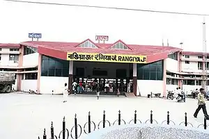 Rangiya Junction an important railway station on New Bongaigaon–Guwahati section | ||||||||||||||||||||||||||||||||||||||||||||||||||||||||||||||||||||||||||||||||||||||||||||||||||||||||||||||||||||||||||||||||||||||||||||||||||||||||||||||||||||||||||||||||||||||||||||||||||||||||||||||||||||||||||||||||||||||||||||||||||||||||||||||||||||||||||||||||||||||||||||||||||||
| Overview | ||||||||||||||||||||||||||||||||||||||||||||||||||||||||||||||||||||||||||||||||||||||||||||||||||||||||||||||||||||||||||||||||||||||||||||||||||||||||||||||||||||||||||||||||||||||||||||||||||||||||||||||||||||||||||||||||||||||||||||||||||||||||||||||||||||||||||||||||||||||||||||||||||||
| Status | Operational | |||||||||||||||||||||||||||||||||||||||||||||||||||||||||||||||||||||||||||||||||||||||||||||||||||||||||||||||||||||||||||||||||||||||||||||||||||||||||||||||||||||||||||||||||||||||||||||||||||||||||||||||||||||||||||||||||||||||||||||||||||||||||||||||||||||||||||||||||||||||||||||||||||
| Owner | Indian Railways | |||||||||||||||||||||||||||||||||||||||||||||||||||||||||||||||||||||||||||||||||||||||||||||||||||||||||||||||||||||||||||||||||||||||||||||||||||||||||||||||||||||||||||||||||||||||||||||||||||||||||||||||||||||||||||||||||||||||||||||||||||||||||||||||||||||||||||||||||||||||||||||||||||
| Locale | Assam | |||||||||||||||||||||||||||||||||||||||||||||||||||||||||||||||||||||||||||||||||||||||||||||||||||||||||||||||||||||||||||||||||||||||||||||||||||||||||||||||||||||||||||||||||||||||||||||||||||||||||||||||||||||||||||||||||||||||||||||||||||||||||||||||||||||||||||||||||||||||||||||||||||
| Termini | New Bongaigaon Guwahati | |||||||||||||||||||||||||||||||||||||||||||||||||||||||||||||||||||||||||||||||||||||||||||||||||||||||||||||||||||||||||||||||||||||||||||||||||||||||||||||||||||||||||||||||||||||||||||||||||||||||||||||||||||||||||||||||||||||||||||||||||||||||||||||||||||||||||||||||||||||||||||||||||||
| Stations | 24 | |||||||||||||||||||||||||||||||||||||||||||||||||||||||||||||||||||||||||||||||||||||||||||||||||||||||||||||||||||||||||||||||||||||||||||||||||||||||||||||||||||||||||||||||||||||||||||||||||||||||||||||||||||||||||||||||||||||||||||||||||||||||||||||||||||||||||||||||||||||||||||||||||||
| Service | ||||||||||||||||||||||||||||||||||||||||||||||||||||||||||||||||||||||||||||||||||||||||||||||||||||||||||||||||||||||||||||||||||||||||||||||||||||||||||||||||||||||||||||||||||||||||||||||||||||||||||||||||||||||||||||||||||||||||||||||||||||||||||||||||||||||||||||||||||||||||||||||||||||
| Operator(s) | Northeast Frontier Railway | |||||||||||||||||||||||||||||||||||||||||||||||||||||||||||||||||||||||||||||||||||||||||||||||||||||||||||||||||||||||||||||||||||||||||||||||||||||||||||||||||||||||||||||||||||||||||||||||||||||||||||||||||||||||||||||||||||||||||||||||||||||||||||||||||||||||||||||||||||||||||||||||||||
| History | ||||||||||||||||||||||||||||||||||||||||||||||||||||||||||||||||||||||||||||||||||||||||||||||||||||||||||||||||||||||||||||||||||||||||||||||||||||||||||||||||||||||||||||||||||||||||||||||||||||||||||||||||||||||||||||||||||||||||||||||||||||||||||||||||||||||||||||||||||||||||||||||||||||
| Opened | 1962 | |||||||||||||||||||||||||||||||||||||||||||||||||||||||||||||||||||||||||||||||||||||||||||||||||||||||||||||||||||||||||||||||||||||||||||||||||||||||||||||||||||||||||||||||||||||||||||||||||||||||||||||||||||||||||||||||||||||||||||||||||||||||||||||||||||||||||||||||||||||||||||||||||||
| Technical | ||||||||||||||||||||||||||||||||||||||||||||||||||||||||||||||||||||||||||||||||||||||||||||||||||||||||||||||||||||||||||||||||||||||||||||||||||||||||||||||||||||||||||||||||||||||||||||||||||||||||||||||||||||||||||||||||||||||||||||||||||||||||||||||||||||||||||||||||||||||||||||||||||||
| Line length | 158 km (98 mi) | |||||||||||||||||||||||||||||||||||||||||||||||||||||||||||||||||||||||||||||||||||||||||||||||||||||||||||||||||||||||||||||||||||||||||||||||||||||||||||||||||||||||||||||||||||||||||||||||||||||||||||||||||||||||||||||||||||||||||||||||||||||||||||||||||||||||||||||||||||||||||||||||||||
| Track gauge | 1,676 mm (5 ft 6 in) broad gauge | |||||||||||||||||||||||||||||||||||||||||||||||||||||||||||||||||||||||||||||||||||||||||||||||||||||||||||||||||||||||||||||||||||||||||||||||||||||||||||||||||||||||||||||||||||||||||||||||||||||||||||||||||||||||||||||||||||||||||||||||||||||||||||||||||||||||||||||||||||||||||||||||||||
| ||||||||||||||||||||||||||||||||||||||||||||||||||||||||||||||||||||||||||||||||||||||||||||||||||||||||||||||||||||||||||||||||||||||||||||||||||||||||||||||||||||||||||||||||||||||||||||||||||||||||||||||||||||||||||||||||||||||||||||||||||||||||||||||||||||||||||||||||||||||||||||||||||||
History
Early developments within Assam
The Assam Railway and Trading Company played a pioneering role in laying railway tracks in Assam. The first railway line in Assam, 15 miles long, was laid in 1882 between Amolapatty, Dibrugarh and Dinjam Stream for transportation of tea. It was extended up to Makum collieries at Margherita in 1884. The company also established the first passenger railway – Dibru Sadiya Railway.[1]
Assam links pre-independence
During British rule, rail links from Assam to the rest of India were through the eastern part of Bengal. In pre-independence days, there were basically two linkages. In 1908, Eastern Bengal Railway constructed a 581 kilometres (361 mi) long metre gauge line running via Radhikapur, Biral, Parbatipur, Tista, Gitaldaha and Golokganj connected Fakiragram in Assam with Katihar in Bihar.[2] On the eastern side, Assam was linked to numerous other towns in the eastern part of Bengal through the 407 kilometres (253 mi) long Mahisasan-Chittagong Line (what is now the Mahisasan-Shahbajpur defunct transit point), through the 102 kilometres (63 mi) long Kulaura–Chhatak-Companiganj line and Akhaura–Laksam–Chittagong line. The eastern line had been constructed in response to the demand of the Assam tea planters for a railway link to Chittagong port. Assam Bengal Railway started construction of a railway track on the eastern side of Bengal in 1891. A 169 kilometres (105 mi) track between Chittagong and Comilla was opened to traffic in 1895. The 432 kilometres (268 mi) long Chittagong-Comilla-Akhaura-Kulaura-Badarpur section was opened in 1896-1898 and finally extended 183 kilometres (114 mi) more to Lumding in 1903.[3][4][5] The Assam Bengal Railway constructed a branch line to Guwahati, connecting the city to the eastern line in 1900. During the 1900-1910 period, the Eastern Bengal Railway built the Golakganj-Amingaon branch line, thus connecting the western bank of the Brahmaputra to the western line. Apart from the eastern and western lines, there was another link. Eastern Bengal Railway also constructed Dewanganj - Goalpara - Guwahati Railway line in 1918. This was a 307 kilometres (191 mi) long meter gauge Line, which got destroyed in Assam Earthquake of 1950 due to change of course of River Brahmaputra. The lines in Goalpara to Hatisinghmari section & Dewanganj to Dantbhanga section were severely damaged & destroyed. Later in 1998's, the Guwhati-Goalpara Line was made & 2.284 kilometres (1.419 mi) long Naranarayan Setu was constructed to connect New Bongaigaon-Jogighopa broad gauge section of Siliguri - Guwahati Line.
Assam Link Project
With the partition of India in 1947, all the three links were lost and for a short period the railway system in Assam was delinked from the rest of India. Indian Railways took up the Assam Link Project in 1948 to build a rail link between Fakiragram and Kishanganj via Coochbehar & Siliguri. Fakiragram was connected to the Indian railway system in 1950 through the Indian portion of North Bengal with a metre-gauge track.[6] The New Bongaigaon–Guwahati section was converted to broad gauge. Broad gauge reached Guwahati in 1984.[7][8]
Saraighat Bridge
The construction of the 1.495 kilometres (0.929 mi) long Saraighat Bridge, the first rail-cum-road bridge across the Brahmaputra, was an event of great excitement. Jawaharlal Nehru, India’s first prime minister formally laid the foundation stone on 10 January 1960 and it was completed in 1962, connecting the two parts of the metre gauge railways in Assam.[9]
Siliguri-Jogihopa-Kamakhya line
The 312 km (194 mi) long 1,000 mm (3 ft 3 3⁄8 in) wide meter gauge Siliguri-Jogihopa line via Sevoke, Malbazar, Dalgaon, Hasimara, Alipurduar & New Bongaigaon was constructed between 1963 and 1965 & was converted to 1,676 mm (5 ft 6 in) broad gauge in 1998 .[10] The 2.285 kilometres (1.420 mi) long Naranarayan Setu was constructed in 1998, thereby paving the way for linking Jogihopa with Kamakhya.[11]
Dudhnoi-Mendipathar branch line
The 25.27 kilometres (15.70 mi) long line between Dudhnoi in Assam and Deepa in Meghalaya was proposed in the Rail budget of 1992–93. Later the alignment was changed to Dudhnoi-Mendipathar in 2007 due to opposition of local people. Due to late handover of land to railways in Assam and Meghalaya, the progress of work was slow up to 2013. Acquisition of land was completed by March 2013. This 16.81 kilometres (10.45 mi) long rail line is the first foray of Indian Railways into Meghalaya. Mendipathar railway station was inaugurated by the Prime minister of India, Narendra Modi on 30 November 2014, through a video feed to the ceremony gathering at Mendipathar.[12]
Electrification
Electrification of the entire 593 kilometres (368 mi) long Katihar–Guwahati route is planned to be executed by 2024.[13]
References
- "Northeast Frontier Railway". Archived from the original on 2 May 2014. Retrieved 21 January 2012.
- "Geography - International". IRFCA. Retrieved 10 December 2011.
- Fida, Quazi Abul (2012). "Railway". In Islam, Sirajul; Jamal, Ahmed A. (eds.). Banglapedia: National Encyclopedia of Bangladesh (Second ed.). Asiatic Society of Bangladesh.
- "Report on the administration of North East India (1921-22)". p. 46. 1984. Retrieved 16 December 2011.
- S.N.Singh, Amarendra Narain, Purnendu Kumar (January 2006). Socio Economic and Political Problems of Tea Garden Workers: A Study of Assam, Published 2006, ISBN 81-8324-098-4. p. 105. Mittal Publications, New Delhi. ISBN 9788183240987. Retrieved 16 December 2011.CS1 maint: multiple names: authors list (link)
- "Indian Railways History". Northeast Frontier Railway. IRSE. Archived from the original on 25 April 2012. Retrieved 10 December 2011.
- "Gauge conversion project in Assam". The Hindu Business Line. 24 May 2000. Retrieved 10 December 2011.
- "Some Milestones of NF Railway". Archived from the original on 24 November 2011. Retrieved 28 January 2012.
- "Bridges: The Spectacular Feat of Indian Railways" (PDF). National Informatics Centre. Archived from the original (PDF) on 5 March 2016. Retrieved 21 January 2012.
- Moonis Raza & Yash Aggarwal (1986). Transport Geography of India: Commodity Flow and the Regional Structure of Indian Economy. page 60. Concept Publishing Company, A-15/16 Commercial Block, Mohan Garden, New Delhi - 110059. ISBN 81-7022-089-0. Retrieved 2 May 2013.
- "Model project on Construction of Naranarayana Setu over river Brahmaputra at Jogihopa" (PDF). Archived from the original (PDF) on 14 April 2014. Retrieved 8 May 2013.
- "Statement showing Category-wise No. of stations in IR based on Pass. earning of 2011" (PDF). Retrieved 15 January 2016.
- "Railway electrification project to touch North East soon". Business Standard. 23 August 2011. Retrieved 21 January 2012.