New Hanover Township, New Jersey
New Hanover Township is a township in Burlington County, New Jersey, United States. As of the 2010 United States Census, the township's population was 7,385,[7][8][9] reflecting a decline of 2,359 (-24.2%) from the 9,744 counted in the 2000 Census, which had in turn increased by 198 (+2.1%) from the 9,546 counted in the 1990 Census.[17] The township is located in the Delaware Valley.
New Hanover Township, New Jersey | |
|---|---|
| Township of New Hanover | |
 Cookstown, an unincorporated community within New Hanover Township | |
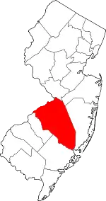
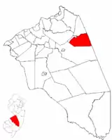 New Hanover Township highlighted in Burlington County. Inset map: Burlington County highlighted in the State of New Jersey. | |
 New Hanover Township Location in Burlington County  New Hanover Township Location in New Jersey  New Hanover Township Location in the United States | |
| Coordinates: 40.013969°N 74.575016°W[1][2] | |
| Country | |
| State | |
| County | |
| Royal charter | December 2, 1723 |
| Incorporated | February 21, 1798 |
| Government | |
| • Type | Township |
| • Body | Township Committee |
| • Mayor | Paul D. Peterla (R, term ends December 31, 2020)[4][5] |
| • Municipal clerk | Donna Mull[4] |
| Area | |
| • Total | 22.56 sq mi (58.42 km2) |
| • Land | 22.33 sq mi (57.84 km2) |
| • Water | 0.22 sq mi (0.58 km2) 0.99% |
| Area rank | 122nd of 565 in state 11th of 40 in county[1] |
| Elevation | 105 ft (32 m) |
| Population | |
| • Total | 7,385 |
| • Estimate (2019)[10] | 7,808 |
| • Rank | 310th of 566 in state 24th of 40 in county[11] |
| • Density | 333.0/sq mi (128.6/km2) |
| • Density rank | 469th of 566 in state 33rd of 40 in county[11] |
| Time zone | UTC−05:00 (Eastern (EST)) |
| • Summer (DST) | UTC−04:00 (Eastern (EDT)) |
| ZIP Code | |
| Area code(s) | 609[13] |
| FIPS code | 3400551510[1][14][15] |
| GNIS feature ID | 0882088[16] |
| Website | None |
History
New Hanover was originally formed by Royal charter on December 2, 1723, from portions of Chesterfield Township and Springfield Township. New Hanover was incorporated as one of New Jersey's initial 104 townships by an act of the New Jersey Legislature on February 21, 1798. Portions of the township were taken to form Pemberton borough (December 15, 1826), Pemberton Township (March 10, 1846), North Hanover Township (April 12, 1905) and Wrightstown (March 4, 1918).[18][19]
Geography
According to the United States Census Bureau, the township had a total area of 22.56 square miles (58.42 km2), including 22.33 square miles (57.84 km2) of land and 0.22 square miles (0.58 km2) of water (0.99%).[1][2]
Fort Dix is an unincorporated community and census-designated place (CDP) with a total 2010 Census population of 7,716 located in portions of New Hanover Township (5,951 of the total), Pemberton Township (1,765 of CDP's residents) and Springfield Township (with no residents in the CDP).[20] McGuire AFB CDP is a CDP with a 2010 population of 3,710 located in portions of New Hanover Township (737 of the total) and North Hanover Township (2,973).[21]
Cookstown is a small unincorporated community located near Fort Dix. Other unincorporated communities, localities and place names located partially or completely within the township include Cranberry Hall, Cranbury Park, Fountain Green, Lewistown, Mahalala, Pointville, Shreve and Taylors Mountain.[22]
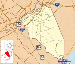
The township borders North Hanover Township, Pemberton Township and Wrightstown in Burlington County; and Plumsted Township in Ocean County.[23][24][25]
The township is one of 56 South Jersey municipalities that are included within the New Jersey Pinelands National Reserve, a protected natural area of unique ecology covering 1,100,000 acres (450,000 ha), that has been classified as a United States Biosphere Reserve and established by Congress in 1978 as the nation's first National Reserve.[26] Part of the township is included in the state-designated Pinelands Area, which includes portions of Burlington County, along with areas in Atlantic, Camden, Cape May, Cumberland, Gloucester and Ocean counties.[27]
Demographics
| Historical population | |||
|---|---|---|---|
| Census | Pop. | %± | |
| 1810 | 2,536 | — | |
| 1820 | 2,642 | 4.2% | |
| 1830 | 2,859 | * | 8.2% |
| 1840 | 3,045 | 6.5% | |
| 1850 | 2,245 | * | −26.3% |
| 1860 | 2,526 | 12.5% | |
| 1870 | 2,536 | 0.4% | |
| 1880 | 2,373 | −6.4% | |
| 1890 | 1,962 | −17.3% | |
| 1900 | 1,847 | * | −5.9% |
| 1910 | 948 | −48.7% | |
| 1920 | 5,606 | * | 491.4% |
| 1930 | 646 | −88.5% | |
| 1940 | 983 | 52.2% | |
| 1950 | 18,168 | 1,748.2% | |
| 1960 | 28,528 | 57.0% | |
| 1970 | 27,410 | −3.9% | |
| 1980 | 14,258 | −48.0% | |
| 1990 | 9,546 | −33.0% | |
| 2000 | 9,744 | 2.1% | |
| 2010 | 7,385 | −24.2% | |
| 2019 (est.) | 7,808 | [10][28][29] | 5.7% |
| Population sources: 1800–2000[30] 1800–1920[31] 1840[32] 1850-1870[33] 1850[34] 1870[35] 1880-1890[36] 1890–1910[37] 1910–1930[38] 1930–1990[39] 2000[40][41] 2010[7][8][9] * = Lost territory in previous decade.[18] 1920 data includes 5,018 in Camp Dix.[38] | |||
Census 2010
The 2010 United States Census counted 7,385 people, 551 households, and 441 families in the township. The population density was 333.0 per square mile (128.6/km2). There were 613 housing units at an average density of 27.6 per square mile (10.7/km2). The racial makeup was 54.06% (3,992) White, 33.57% (2,479) Black or African American, 0.65% (48) Native American, 2.04% (151) Asian, 0.08% (6) Pacific Islander, 6.24% (461) from other races, and 3.36% (248) from two or more races. Hispanic or Latino of any race were 20.96% (1,548) of the population.[7]
Of the 551 households, 50.8% had children under the age of 18; 67.2% were married couples living together; 9.3% had a female householder with no husband present and 20.0% were non-families. Of all households, 16.7% were made up of individuals and 2.4% had someone living alone who was 65 years of age or older. The average household size was 3.09 and the average family size was 3.50.[7]
7.9% of the population were under the age of 18, 7.4% from 18 to 24, 46.7% from 25 to 44, 34.2% from 45 to 64, and 3.7% who were 65 years of age or older. The median age was 41.1 years. For every 100 females, the population had 624.0 males. For every 100 females ages 18 and older there were 830.1 males.[7]
The Census Bureau's 2006–2010 American Community Survey showed that (in 2010 inflation-adjusted dollars) median household income was $63,796 (with a margin of error of +/- $9,062) and the median family income was $61,083 (+/- $9,842). Males had a median income of $33,368 (+/- $5,196) versus $38,977 (+/- $6,300) for females. The per capita income for the borough was $15,387 (+/- $1,620). About 0.7% of families and 0.7% of the population were below the poverty line, including 0.8% of those under age 18 and 8.5% of those age 65 or over.[42]
Census 2000
As of the 2000 United States Census[14] there were 9,744 people, 1,162 households, and 991 families residing in the township. The population density was 437.3 people per square mile (168.9/km2). There were 1,381 housing units at an average density of 62.0 per square mile (23.9/km2). The racial makeup of the township was 64.1% White, 28.9% African American, 0.4% Native American, 1.5% Asian, 0.1% Pacific Islander, 2.7% from other races, and 2.3% from two or more races. Hispanic or Latino of any race were 19.4% of the population.[40][41]
There were 1,162 households, out of which 60.9% had children under the age of 18 living with them, 78.1% were married couples living together, 3.7% had a female householder with no husband present, and 14.7% were non-families. 13.7% of all households were made up of individuals, and 0.9% had someone living alone who was 65 years of age or older. The average household size was 3.14 and the average family size was 3.46.[40][41]
In the township the population was spread out, with 14.5% under the age of 18, 15.7% from 18 to 24, 55.4% from 25 to 44, 13.2% from 45 to 64, and 1.3% who were 65 years of age or older. The median age was 32 years. For every 100 females, there were 401.8 males. For every 100 females age 18 and over, there were 561.7 males.[40][41]
The median income for a household in the township was $44,386, and the median income for a family was $45,511. Males had a median income of $26,428 versus $23,050 for females. The per capita income for the township was $12,140. About 3.2% of families and 3.9% of the population were below the poverty line, including 3.3% of those under age 18 and 12.8% of those age 65 or over.[40][41]
Government
Local government
New Hanover Township is governed under the Township form of New Jersey municipal government, one of 141 municipalities (of the 565) statewide that use this form, the second-most commonly used form of government in the state.[43] The Township Committee is comprised of five members, who are elected directly by the voters at-large in partisan elections to serve three-year terms of office on a staggered basis, with either one or two seats coming up for election each year as part of the November general election in a three-year cycle.[3][44] At an annual reorganization meeting held in January after each election, the Township Committee selects one of its members to serve as Mayor and another as Deputy Mayor.
As of 2020, the members of the New Hanover Township Committee are Mayor Paul D. Peterla (R, term on committee and as mayor ends December 31, 2020), Rick Koshak (R, 2021), Patrick Murphy (R, 2021), Yvonne V. Rigney (R, 2020) and Dennis Roohr (R, 2022).[4][45][46][47]
Federal, state and county representation
New Hanover Township is located in the 3rd Congressional District[48] and is part of New Jersey's 12th state legislative district.[8][49][50] Prior to the 2011 reapportionment following the 2010 Census, New Hanover Township had been in the 30th state legislative district.[51]
For the 116th United States Congress, New Jersey's 3rd Congressional District is represented by Andy Kim (D, Bordentown).[52] New Jersey is represented in the United States Senate by Democrats Cory Booker (Newark, term ends 2021)[53] and Bob Menendez (Paramus, term ends 2025).[54][55]
For the 2018–2019 session (Senate, General Assembly), the 12th Legislative District of the New Jersey Legislature is represented in the State Senate by Samuel D. Thompson (R, Old Bridge Township) and in the General Assembly by Robert D. Clifton (R, Matawan) and Ronald S. Dancer (R, Plumsted Township).[56][57]
Burlington County is governed by a board of chosen freeholders, whose five members are elected at-large in partisan elections to three-year terms of office on a staggered basis, with either one or two seats coming up for election each year; at an annual reorganization meeting, the board selects a director and deputy director from among its members.[58] As of 2018, Burlington County Board of Chosen Freeholders are Director Kate Gibbs (R, Lumberton Township, term as freeholder and as director ends December 31, 2018),[59] Deputy Director Linda Hughes (R, Evesham Township, term as freeholder and as deputy director ends 2018)[60] Tom Pullion (D, Edgewater Park, 2020),[61] Balvir Singh (D, Burlington Township, 2020),[62] and Latham Tiver (R, Southampton Township, 2019).[63][58][64][65] Burlington County's Constitutional Officers are County Clerk Tim Tyler (R, Fieldsboro, 2018),[66][67] Sheriff Jean E. Stanfield (R, Westampton, 2019)[68][69] and Surrogate Mary Ann O'Brien (R, Medford, 2021).[70][71][65]
Politics
As of March 23, 2011, there were a total of 689 registered voters in New Hanover Township, of which 148 (21.5% vs. 33.3% countywide) were registered as Democrats, 278 (40.3% vs. 23.9%) were registered as Republicans and 262 (38.0% vs. 42.8%) were registered as Unaffiliated. There was one voter registered to another party.[72] Among the township's 2010 Census population, 9.3% (vs. 61.7% in Burlington County) were registered to vote, including 10.1% of those ages 18 and over (vs. 80.3% countywide).[72][73]
In the 2012 presidential election, Republican Mitt Romney received 246 votes (55.2% vs. 40.2% countywide), ahead of Democrat Barack Obama with 194 votes (43.5% vs. 58.1%) and other candidates with 6 votes (1.3% vs. 1.0%), among the 446 ballots cast by the township's 742 registered voters, for a turnout of 60.1% (vs. 74.5% in Burlington County).[74][75] In the 2008 presidential election, Republican John McCain received 264 votes (56.3% vs. 39.9% countywide), ahead of Democrat Barack Obama with 190 votes (40.5% vs. 58.4%) and other candidates with 3 votes (0.6% vs. 1.0%), among the 469 ballots cast by the township's 674 registered voters, for a turnout of 69.6% (vs. 80.0% in Burlington County).[76] In the 2004 presidential election, Republican George W. Bush received 256 votes (65.3% vs. 46.0% countywide), ahead of Democrat John Kerry with 131 votes (33.4% vs. 52.9%) and other candidates with 4 votes (1.0% vs. 0.8%), among the 392 ballots cast by the township's 572 registered voters, for a turnout of 68.5% (vs. 78.8% in the whole county).[77]
In the 2013 gubernatorial election, Republican Chris Christie received 224 votes (76.7% vs. 61.4% countywide), ahead of Democrat Barbara Buono with 57 votes (19.5% vs. 35.8%) and other candidates with 3 votes (1.0% vs. 1.2%), among the 292 ballots cast by the township's 726 registered voters, yielding a 40.2% turnout (vs. 44.5% in the county).[78][79] In the 2009 gubernatorial election, Republican Chris Christie received 206 votes (59.2% vs. 47.7% countywide), ahead of Democrat Jon Corzine with 97 votes (27.9% vs. 44.5%), Independent Chris Daggett with 15 votes (4.3% vs. 4.8%) and other candidates with 10 votes (2.9% vs. 1.2%), among the 348 ballots cast by the township's 723 registered voters, yielding a 48.1% turnout (vs. 44.9% in the county).[80]
Education
Public school students in pre-kindergarten through eighth grade attend the New Hanover Township School, which serves students from both New Hanover Township and Wrightstown as part of the New Hanover Township School District.[3][81] As of the 2018–19 school year, the district, comprised of one school, had an enrollment of 177 students and 23.6 classroom teachers (on an FTE basis), for a student–teacher ratio of 7.5:1.[82] In the 2016–17 school year, the district had the 40th-smallest enrollment of any school district in the state.[83]
For ninth through twelfth grades, students from both New Hanover Township and Wrightstown attend Bordentown Regional High School as part of a sending/receiving relationship with the Bordentown Regional School District, a regional K-12 school district that serves students from Bordentown City, Bordentown Township and Fieldsboro Borough.[84][85][86][87] As of the 2018–19 school year, the high school had an enrollment of 770 students and 53.8 classroom teachers (on an FTE basis), for a student–teacher ratio of 14.3:1.[88]
Students from New Hanover Township, and from all of Burlington County, are eligible to attend the Burlington County Institute of Technology, a countywide public school district that serves the vocational and technical education needs of students at the high school and post-secondary level at its campuses in Medford and Westampton Township.[89]
Transportation
_in_New_Hanover_Township%252C_Burlington_County%252C_New_Jersey.jpg.webp)
Roads and highways
As of May 2010, the township had a total of 24.13 miles (38.83 km) of roadways, of which 13.11 miles (21.10 km) were maintained by the municipality, 10.70 miles (17.22 km) by Burlington County and 0.32 miles (0.51 km) by the New Jersey Department of Transportation.[90]
New Jersey Route 68 reaches its southern terminus in New Hanover Township. County Route 545 has a gap in New Hanover due to Joint Base McGuire-Dix-Lakehurst.
Public transportation
NJ Transit provides bus service in the township on the 317 route between Asbury Park and Philadelphia.[91][92]
Notable people
People who were born in, residents of, or otherwise closely associated with New Hanover Township include:
- Edward Settle Godfrey (1843–1932), United States Army Brigadier General who received the Medal of Honor for leadership as a captain during the Indian Wars.[93][94]
References
- 2019 Census Gazetteer Files: New Jersey Places, United States Census Bureau. Accessed July 1, 2020.
- US Gazetteer files: 2010, 2000, and 1990, United States Census Bureau. Accessed September 4, 2014.
- 2012 New Jersey Legislative District Data Book, Rutgers University Edward J. Bloustein School of Planning and Public Policy, March 2013, p. 103.
- 2019 Municipal User Friendly Budget for Township of New Hanover, New Jersey Department of Community Affairs. Accessed October 20, 2019.
- 2020 New Jersey Mayors Directory, New Jersey Department of Community Affairs. Accessed February 1, 2020.
- U.S. Geological Survey Geographic Names Information System: Township of New Hanover, Geographic Names Information System. Accessed March 8, 2013.
- DP-1 – Profile of General Population and Housing Characteristics: 2010 for New Hanover township, Burlington County, New Jersey, United States Census Bureau. Accessed June 21, 2012.
- Municipalities Sorted by 2011–2020 Legislative District, New Jersey Department of State. Accessed February 1, 2020.
- Profile of General Demographic Characteristics: 2010 for New Hanover township, New Jersey Department of Labor and Workforce Development. Accessed June 21, 2012.
- QuickFacts for New Hanover township, Burlington County, New Jersey; Burlington County, New Jersey; New Jersey from Population estimates, July 1, 2019, (V2019), United States Census Bureau. Accessed May 21, 2020.
- GCT-PH1 Population, Housing Units, Area, and Density: 2010 – State – County Subdivision from the 2010 Census Summary File 1 for New Jersey, United States Census Bureau. Accessed July 15, 2013.
- Look Up a ZIP Code for Cookstown, NJ, United States Postal Service. Accessed June 21, 2012.
- Area Code Lookup – NPA NXX for Cookstown, NJ, Area-Codes.com. Accessed October 8, 2014.
- U.S. Census website, United States Census Bureau. Accessed September 4, 2014.
- Geographic codes for New Jersey, Missouri Census Data Center. Accessed September 1, 2019.
- US Board on Geographic Names, United States Geological Survey. Accessed September 4, 2014.
- Table 7. Population for the Counties and Municipalities in New Jersey: 1990, 2000 and 2010, New Jersey Department of Labor and Workforce Development, February 2011. Accessed June 21, 2012.
- Snyder, John P. The Story of New Jersey's Civil Boundaries: 1606–1968, Bureau of Geology and Topography; Trenton, New Jersey; 1969. p. 97. Accessed June 21, 2012.
- Halperin, Frank. "New Hanover: Land of thriving farms" Archived 2015-11-17 at the Wayback Machine, Courier-Post, October 18, 2006. Accessed September 9, 2015.
- DP-1 – Profile of General Population and Housing Characteristics: 2010 Demographic Profile Data for Fort Dix CDP, Burlington County, New Jersey Archived 2020-02-12 at Archive.today, United States Census Bureau. Accessed June 21, 2012
- DP-1 – Profile of General Population and Housing Characteristics: 2010 Demographic Profile Data for McGuire AFB CDP, Burlington County, New Jersey Archived 2020-02-12 at Archive.today, United States Census Bureau. Accessed June 21, 2012.
- Locality Search, State of New Jersey. Accessed April 27, 2015.
- Areas touching New Hanover Township, MapIt. Accessed March 1, 2020.
- Burlington County Map, Coalition for a Healthy NJ. Accessed March 1, 2020.
- New Jersey Municipal Boundaries, New Jersey Department of Transportation. Accessed November 15, 2019.
- The Pinelands National Reserve, New Jersey Pinelands Commission. Accessed November 27, 2013.
- Pinelands Municipalities, New Jersey Pinelands Commission, April 2003. Accessed November 27, 2013.
- Annual Estimates of the Resident Population for Minor Civil Divisions in New Jersey: April 1, 2010 to July 1, 2019, United States Census Bureau. Accessed May 21, 2020.
- Census Estimates for New Jersey April 1, 2010 to July 1, 2019, United States Census Bureau. Accessed May 21, 2020.
- Barnett, Bob. Population Data for Burlington County Municipalities, 1800–2000, WestJersey.org, January 6, 2011. Accessed November 27, 2013.
- Compendium of censuses 1726–1905: together with the tabulated returns of 1905, New Jersey Department of State, 1906. Accessed July 16, 2013.
- Bowen, Francis. American Almanac and Repository of Useful Knowledge for the Year 1843, p. 231, David H. Williams, 1842. Accessed July 16, 2013. Listed as "Hanover".
- Raum, John O. The History of New Jersey: From Its Earliest Settlement to the Present Time, Volume 1, p. 264, J. E. Potter and company, 1877. Accessed July 16, 2013. "New Hanover township in 1850 contained a population of 2,245; in 1860, 2,529; and in 1870, 2,536. Jacobstown, Cookstown, Arneytown, Sykesville, Wrightstown, and Pointville, are in this township." The population of 2,529 shown for 1860 is three more than the amount shown in the table.
- Debow, James Dunwoody Brownson. The Seventh Census of the United States: 1850, p. 137. R. Armstrong, 1853. Accessed July 16, 2013.
- Staff. A compendium of the ninth census, 1870, p. 259. United States Census Bureau, 1872. Accessed July 16, 2013.
- Porter, Robert Percival. Preliminary Results as Contained in the Eleventh Census Bulletins: Volume III – 51 to 75, p. 97. United States Census Bureau, 1890. Accessed July 16, 2013.
- Thirteenth Census of the United States, 1910: Population by Counties and Minor Civil Divisions, 1910, 1900, 1890, United States Census Bureau, p. 335. Accessed June 21, 2012.
- "Fifteenth Census of the United States: 1930 – Population Volume I", United States Census Bureau, p. 715. Accessed June 21, 2012. 1920 population includes 5,018 from Camp Dix.
- Table 6. New Jersey Resident Population by Municipality: 1930–1990, New Jersey Department of Labor and Workforce Development. Accessed June 28, 2015.
- Census 2000 Profiles of Demographic / Social / Economic / Housing Characteristics for New Hanover township, Burlington County, New Jersey Archived 2007-07-11 at the Wayback Machine, United States Census Bureau. Accessed July 16, 2013.
- DP-1: Profile of General Demographic Characteristics: 2000 – Census 2000 Summary File 1 (SF 1) 100-Percent Data for New Hanover township, Burlington County, New Jersey Archived 2020-02-12 at Archive.today, United States Census Bureau. Accessed July 16, 2013.
- DP03: Selected Economic Characteristics from the 2006–2010 American Community Survey 5-Year Estimates for New Hanover township, Burlington County, New Jersey Archived 2020-02-12 at Archive.today, United States Census Bureau. Accessed June 21, 2012.
- Inventory of Municipal Forms of Government in New Jersey, Rutgers University Center for Government Studies, July 1, 2011. Accessed November 18, 2019.
- "Forms of Municipal Government in New Jersey", p. 7. Rutgers University Center for Government Studies. Accessed June 3, 2015.
- November 5, 2019 General Election Summary Report Official Results, Burlington County, New Jersey, updated November 16, 2019. Accessed January 1, 2020.
- November 6, 2018 General Election Summary Report Official Results, Burlington County, New Jersey, updated November 17, 2018. Accessed January 1, 2019.
- November 7, 2017 General Election Summary Report Official Results, Burlington County, New Jersey, updated November 16, 2017. Accessed January 1, 2018.
- Plan Components Report, New Jersey Redistricting Commission, December 23, 2011. Accessed February 1, 2020.
- 2019 New Jersey Citizen's Guide to Government, New Jersey League of Women Voters. Accessed October 30, 2019.
- Districts by Number for 2011–2020, New Jersey Legislature. Accessed January 6, 2013.
- 2011 New Jersey Citizen's Guide to Government Archived 2013-06-04 at the Wayback Machine, p. 61, New Jersey League of Women Voters. Accessed May 22, 2015.
- Directory of Representatives: New Jersey, United States House of Representatives. Accessed January 3, 2019.
- About Cory Booker, United States Senate. Accessed January 26, 2015. "He now owns a home and lives in Newark's Central Ward community."
- Biography of Bob Menendez, United States Senate, January 26, 2015. "He currently lives in Paramus and has two children, Alicia and Robert."
- Senators of the 116th Congress from New Jersey. United States Senate. Accessed April 17, 2019. "Booker, Cory A. - (D - NJ) Class II; Menendez, Robert - (D - NJ) Class I"
- Legislative Roster 2018-2019 Session, New Jersey Legislature. Accessed January 22, 2018.
- District 12 Legislators, New Jersey Legislature. Accessed January 22, 2018.
- Board of Chosen Freeholders, Burlington County, New Jersey. Accessed June 6, 2018.
- Kate Gibbs, Burlington County, New Jersey. Accessed June 6, 2018.
- Linda Hughes, Burlington County, New Jersey. Accessed June 6, 2018.
- Tom Pullion, Burlington County, New Jersey. Accessed June 6, 2018.
- Balvir Singh, Burlington County, New Jersey. Accessed June 6, 2018.
- Latham Tiver, Burlington County, New Jersey. Accessed June 6, 2018.
- 2018 County Data Sheet, Burlington County, New Jersey. Accessed June 6, 2018.
- A Guide to Burlington County: 2015, Burlington County, New Jersey. Accessed October 22, 2017.
- County Clerk, Burlington County. Accessed July 19, 2017.
- Members List: Clerks, Constitutional Officers Association of New Jersey. Accessed October 22, 2017.
- Sheriff's Department, Burlington County. Accessed July 19, 2017.
- Members List: Sheriffs, Constitutional Officers Association of New Jersey. Accessed October 22, 2017.
- Surrogate, Burlington County. Accessed July 19, 2017.
- Members List: Surrogates, Constitutional Officers Association of New Jersey. Accessed October 22, 2017.
- Voter Registration Summary – Burlington, New Jersey Department of State Division of Elections, March 23, 2011. Accessed December 25, 2014.
- GCT-P7: Selected Age Groups: 2010 – State – County Subdivision; 2010 Census Summary File 1 for New Jersey Archived 2020-02-12 at Archive.today, United States Census Bureau. Accessed December 25, 2014.
- Presidential November 6, 2012 General Election Results – Burlington County Archived December 26, 2014, at the Wayback Machine, New Jersey Department of State Division of Elections, March 15, 2013. Accessed December 25, 2014.
- Number of Registered Voters and Ballots Cast November 6, 2012 General Election Results – Burlington County Archived December 26, 2014, at the Wayback Machine, New Jersey Department of State Division of Elections, March 15, 2013. Accessed December 25, 2014.
- 2008 Presidential General Election Results: Burlington County, New Jersey Department of State Division of Elections, December 23, 2008. Accessed December 25, 2014.
- 2004 Presidential Election: Burlington County, New Jersey Department of State Division of Elections, December 13, 2004. Accessed December 25, 2014.
- 2013 Governor: Burlington County, New Jersey Department of State Division of Elections, January 29, 2014. Accessed December 25, 2014.
- Number of Registered Voters and Ballots Cast November 5, 2013 General Election Results : Burlington County, New Jersey Department of State Division of Elections, January 29, 2014. Accessed December 25, 2014.
- 2009 Governor: Burlington County Archived 2016-01-13 at the Wayback Machine, New Jersey Department of State Division of Elections, December 31, 2009. Accessed December 25, 2014.
- New Hanover Township School District 2014 Report Card Narrative, New Jersey Department of Education. Accessed June 30, 2016. "Built in 1938 with funding from the Public Works Administration, the New Hanover Township School currently serves the residents of Wrightstown and Cookstown as a vibrant, growing community of diverse learners spanning grades PK through 8."
- District information for New Hanover Township, National Center for Education Statistics. Accessed April 1, 2020.
- Guion, Payton. "These 43 N.J. school districts have fewer than 200 students", NJ Advance Media for NJ.com, September 2017. Accessed January 30, 2020. "Based on data from the state Department of Education from the last school year and the Census Bureau, NJ Advance Media made a list of the smallest of the small school districts in the state, excluding charter schools and specialty institutions.... 40. New Hanover Township (tie) – Enrollment: 190; Grades: Pre-K-8; County: Burlington"
- District Information, Bordentown Regional School District. Accessed August 18, 2020. "Our district is comprised of the Township of Bordentown, the City of Bordentown and the Borough of Fieldsboro. New Hanover Township sends students on a tuition basis grades 9-12."
- Bordentown Regional School District 2016 Report Card Narrative, New Jersey Department of Education. Accessed July 21, 2017. "Bordentown Regional School District is a vibrant learning community, proudly serving the communities of Fieldsboro, Bordentown City and Bordentown Township.... In addition to the three aforementioned communities, Bordentown Regional High School also welcomes students from New Hanover into its ninth-twelfth grade population."
- Staff. "Regional School Districts", Burlington County Times, April 26, 2015. Accessed June 2, 2016. "Bordentown Regional – Serves: Bordentown City, Bordentown Township, Fieldsboro, New Hanover"
- Zimmaro, Mark. "Figures suggest deficit in New Hanover send-receive school proposal" Archived 2011-12-04 at the Wayback Machine, Burlington County Times, December 4, 2011. Accessed December 17, 2011. "The idea of sending the district’s sixth-, seventh- and eighth-graders to the Bordentown Regional Middle School on a tuition basis surfaced last year, but the school board shot down the proposal by a 4-3 vote.... The district has been considering sending 51 middle school students to Bordentown next year, in a similar agreement the districts have with the high school students. Bordentown Regional High School receives New Hanover and Wrightstown students in a 60-year-old agreement."
- School data for Bordentown Regional High School, National Center for Education Statistics. Accessed April 1, 2020.
- Why Choose BCIT?, Burlington County Institute of Technology. Accessed November 27, 2013.
- Burlington County Mileage by Municipality and Jurisdiction, New Jersey Department of Transportation, May 2010. Accessed November 13, 2013.
- Burlington County Bus/Rail Connections, NJ Transit, backed up by the Internet Archive as of January 28, 2010. Accessed November 28, 2013.
- South Jersey Transit Guide Archived 2018-09-29 at the Wayback Machine, Cross County Connection, as of April 1, 2010. Accessed November 28, 2013.
- Gen. Edward S. Godfrey House, National Register of Historic Places, listed February 28, 1997. Accessed January 6, 2021. "The General Edward Settle Godfrey House is a mid-eighteenth century Georgian and expanded Federal style frame farmhouse situated on the corner of Main Street and Wrightstown-Cookstown Road in Cookstown, New Hanover Township, Burlington County, New Jersey.... The General Godfrey House is significant under National Register Criterion B for its association with Brigadier General Edward Settle Godfrey, a noted nineteenth-century cavalry officer with the United States Army.... Godfrey married Ida Emley in 1892 and in 1907 they moved into the house."
- "Edward Settle Godfrey". at ArlingtonCemetery•net. (Unofficial website). "Brigadier General Edward Settle Godfrey 88 retired Indian fighter of the Army who died Friday at his home in Cookstown, New Jersey, was buried this afternoon in Arlington National Cemetery with full military honors."
External links
| Wikimedia Commons has media related to New Hanover Township, New Jersey. |
- New Hanover Township Public Schools
- New Hanover Township School's 2015–16 School Performance Report from the New Jersey Department of Education
- School Data for the New Hanover Township School, National Center for Education Statistics
- Bordentown Regional High School