Springfield Township, Burlington County, New Jersey
Springfield Township is a township in Burlington County, New Jersey, United States. As of the 2010 United States Census, the township's population was 3,414[9][10][11] reflecting an increase of 187 (+5.8%) from the 3,227 counted in the 2000 Census, which had in turn increased by 199 (+6.6%) from the 3,028 counted in the 1990 Census.[20]
Springfield Township, New Jersey | |
|---|---|
| Township of Springfield | |
.jpg.webp) Arneys Mount, the highest point in Burlington County, in Springfield Township | |
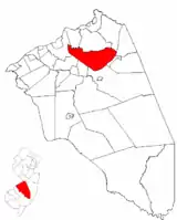 Springfield Township highlighted in Burlington County. Inset map: Burlington County highlighted in the State of New Jersey. | |
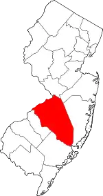
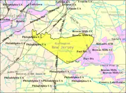 Census Bureau map of Springfield Township, Burlington County, New Jersey | |
 Springfield Township Location in Burlington County  Springfield Township Location in New Jersey  Springfield Township Location in the United States | |
| Coordinates: 40.041216°N 74.710125°W[1][2] | |
| Country | |
| State | |
| County | |
| Formed | November 6, 1688 |
| Royal charter | January 13, 1713 |
| Incorporated | February 21, 1798 |
| Government | |
| • Type | Faulkner Act (council–manager) |
| • Body | Township Council |
| • Mayor | Denis S. McDaniel (R, term ends December 31, 2020)[4][5] |
| • Manager | J. Paul Keller[6] |
| • Municipal clerk | Patricia A. Clayton[7] |
| Area | |
| • Total | 29.57 sq mi (76.58 km2) |
| • Land | 29.51 sq mi (76.44 km2) |
| • Water | 0.06 sq mi (0.15 km2) 0.19% |
| Area rank | 92nd of 565 in state 10th of 40 in county[1] |
| Elevation | 69 ft (21 m) |
| Population | |
| • Total | 3,414 |
| • Estimate (2019)[12] | 3,257 |
| • Rank | 435th of 566 in state 32nd of 40 in county[13] |
| • Density | 114.0/sq mi (44.0/km2) |
| • Density rank | 535th of 566 in state 37th of 40 in county[13] |
| Time zone | UTC−05:00 (Eastern (EST)) |
| • Summer (DST) | UTC−04:00 (Eastern (EDT)) |
| ZIP Code | |
| Area code(s) | 609[16] |
| FIPS code | 3400569990[1][17][18] |
| GNIS feature ID | 0882106[1][19] |
| Website | www |
History
Springfield was originally formed on November 6, 1688, and reformed by Royal charter on January 13, 1713. Springfield Township was incorporated by the Township Act of 1798 of the New Jersey Legislature on February 21, 1798, as one of New Jersey's initial group of 104 townships. Portions of the township were taken on December 2, 1723, to form New Hanover Township.[21] The township's name derives from springs and brooks in the area.[22]
Geography
According to the United States Census Bureau, the township had a total area of 29.57 square miles (76.58 km2), including 29.51 square miles (76.44 km2) of land and 0.06 square miles (0.15 km2) of water (0.19%).[1][2]
Juliustown (2010 Census population of 429[23]) is an unincorporated community and census-designated place (CDP) located entirely within Springfield Township, while Fort Dix (total population of 7,716 as of 2010[24]) is a CDP located in parts of Springfield Township, New Hanover Township and Pemberton Township.[25]
Other unincorporated communities, localities and place names located partially or completely within the township include Arneys Mount, Chambers Corner, Ellis, Folwell, Jacksonville, Jobstown, Pine Lane and Powell.[26]
The township borders the Burlington County municipalities of Burlington Township, Chesterfield Township, Eastampton Township, Florence Township, Mansfield Township, North Hanover Township, Pemberton Township and Wrightstown.[27][28][29]
The township is one of 56 South Jersey municipalities that are included within the New Jersey Pinelands National Reserve, a protected natural area of unique ecology covering 1,100,000 acres (450,000 ha), that has been classified as a United States Biosphere Reserve and established by Congress in 1978 as the nation's first National Reserve.[30] Part of the township is included in the state-designated Pinelands Area, which includes portions of Burlington County, along with areas in Atlantic, Camden, Cape May, Cumberland, Gloucester and Ocean counties.[31]
Demographics
| Historical population | |||
|---|---|---|---|
| Census | Pop. | %± | |
| 1810 | 1,500 | — | |
| 1820 | 1,568 | 4.5% | |
| 1830 | 1,534 | −2.2% | |
| 1840 | 1,632 | 6.4% | |
| 1850 | 1,827 | 11.9% | |
| 1860 | 1,810 | −0.9% | |
| 1870 | 1,761 | −2.7% | |
| 1880 | 1,886 | 7.1% | |
| 1890 | 1,670 | −11.5% | |
| 1900 | 1,382 | −17.2% | |
| 1910 | 1,278 | −7.5% | |
| 1920 | 1,223 | −4.3% | |
| 1930 | 1,326 | 8.4% | |
| 1940 | 1,299 | −2.0% | |
| 1950 | 1,562 | 20.2% | |
| 1960 | 1,956 | 25.2% | |
| 1970 | 2,244 | 14.7% | |
| 1980 | 2,691 | 19.9% | |
| 1990 | 3,028 | 12.5% | |
| 2000 | 3,227 | 6.6% | |
| 2010 | 3,414 | 5.8% | |
| 2019 (est.) | 3,257 | [12][32] | −4.6% |
| Population sources: 1810-2000[33] 1810-1920[34] 1840[35] 1850-1870[36] 1850[37] 1870[38] 1890-1910[39] 1910-1930[40] 1930-1990[41] 2000[42][43] 2010[9][10][11] | |||
Census 2010
The 2010 United States Census counted 3,414 people, 1,162 households, and 941 families in the township. The population density was 114.0 per square mile (44.0/km2). There were 1,217 housing units at an average density of 40.6 per square mile (15.7/km2). The racial makeup was 90.60% (3,093) White, 3.81% (130) Black or African American, 0.21% (7) Native American, 2.55% (87) Asian, 0.00% (0) Pacific Islander, 1.20% (41) from other races, and 1.64% (56) from two or more races. Hispanic or Latino of any race were 3.72% (127) of the population.[9]
Of the 1,162 households, 33.7% had children under the age of 18; 69.4% were married couples living together; 7.7% had a female householder with no husband present and 19.0% were non-families. Of all households, 13.3% were made up of individuals and 5.4% had someone living alone who was 65 years of age or older. The average household size was 2.93 and the average family size was 3.24.[9]
23.0% of the population were under the age of 18, 8.0% from 18 to 24, 20.3% from 25 to 44, 35.4% from 45 to 64, and 13.3% who were 65 years of age or older. The median age was 44.3 years. For every 100 females, the population had 102.9 males. For every 100 females ages 18 and older there were 103.0 males.[9]
The Census Bureau's 2006-2010 American Community Survey showed that (in 2010 inflation-adjusted dollars) median household income was $85,417 (with a margin of error of +/- $13,463) and the median family income was $102,337 (+/- $14,017). Males had a median income of $62,813 (+/- $16,928) versus $47,361 (+/- $11,194) for females. The per capita income for the borough was $37,901 (+/- $4,219). About 2.6% of families and 3.4% of the population were below the poverty line, including 2.8% of those under age 18 and 1.4% of those age 65 or over.[44]
Census 2000
As of the 2000 United States Census[17] there were 3,227 people, 1,098 households, and 906 families residing in the township. The population density was 107.4 people per square mile (41.5/km2). There were 1,138 housing units at an average density of 37.9 per square mile (14.6/km2). The racial makeup of the township was 91.94% White, 3.22% African American, 0.31% Native American, 2.63% Asian, 0.22% from other races, and 1.67% from two or more races. Hispanic or Latino of any race were 1.77% of the population.[42][43]
There were 1,098 households, out of which 36.7% had children under the age of 18 living with them, 73.4% were married couples living together, 5.8% had a female householder with no husband present, and 17.4% were non-families. 13.3% of all households were made up of individuals, and 5.4% had someone living alone who was 65 years of age or older. The average household size was 2.93 and the average family size was 3.22.[42][43]
In the township the population was spread out, with 25.8% under the age of 18, 5.7% from 18 to 24, 29.0% from 25 to 44, 28.7% from 45 to 64, and 10.7% who were 65 years of age or older. The median age was 39 years. For every 100 females, there were 100.1 males. For every 100 females age 18 and over, there were 97.7 males.[42][43]
The median income for a household in the township was $69,268, and the median income for a family was $72,292. Males had a median income of $49,044 versus $31,392 for females. The per capita income for the township was $29,322. About 2.8% of families and 3.6% of the population were below the poverty line, including 1.2% of those under age 18 and 8.5% of those age 65 or over.[42][43]
Parks and recreation
Burlington County Fairgrounds (home of the annual Farm Fair) opened in 2011 at the intersection of Route 206 and Columbus-Jobstown Road.[45]
Government
Local government
Springfield Township operates within the Faulkner Act (formally known as the Optional Municipal Charter Law) under the Council-Manager form of municipal government, implemented by direct petition as of January 1, 2001, having been approved by voters in a November 1999 referendum.[46][47] The township is one of 42 municipalities (of the 565) statewide that use this form of government.[48] The Township Council is comprised of five members elected at-large in a partisan vote to four-year terms on a staggered basis, with either two or three seats coming up for election in even-numbered years as part of the November general election.[3] At a reorganization meeting held during the first week of January following each election, the council selects a mayor and deputy mayor from among its members to serve two-year terms of office.[49][50]
As of 2020, members of the Springfield Township Council are Mayor Denis McDaniel (R, term on council ends December 31, 2022; term as mayor ends 2020), Deputy Mayor Anthony Marinello (R, term on council ends 2022; term as deputy mayor ends 2020), David Frank (R, 2020), John Hlubik (R, 2020) and Peter Sobotka (R, 2022).[4][51][52][53]
Federal, state and county representation
Springfield Township is located in the 3rd Congressional District[54] and is part of New Jersey's 8th state legislative district.[10][55][56] Prior to the 2010 Census, Springfield Township had been part of the 4th Congressional District, a change made by the New Jersey Redistricting Commission that took effect in January 2013, based on the results of the November 2012 general elections.[57]
For the 116th United States Congress, New Jersey's 3rd Congressional District is represented by Andy Kim (D, Bordentown).[58] New Jersey is represented in the United States Senate by Democrats Cory Booker (Newark, term ends 2021)[59] and Bob Menendez (Paramus, term ends 2025).[60][61]
For the 2018–2019 session (Senate, General Assembly), the 8th Legislative District of the New Jersey Legislature is represented in the State Senate by Dawn Marie Addiego (R, Evesham Township) and in the General Assembly by Joe Howarth (R, Evesham Township) and Ryan Peters (R, Hainesport Township).[62][63]
Burlington County is governed by a board of chosen freeholders, whose five members are elected at-large in partisan elections to three-year terms of office on a staggered basis, with either one or two seats coming up for election each year; at an annual reorganization meeting, the board selects a director and deputy director from among its members.[64] As of 2018, Burlington County Board of Chosen Freeholders are Director Kate Gibbs (R, Lumberton Township, term as freeholder and as director ends December 31, 2018),[65] Deputy Director Linda Hughes (R, Evesham Township, term as freeholder and as deputy director ends 2018)[66] Tom Pullion (D, Edgewater Park, 2020),[67] Balvir Singh (D, Burlington Township, 2020),[68] and Latham Tiver (R, Southampton Township, 2019).[69][64][70][71] Burlington County's Constitutional Officers are County Clerk Tim Tyler (R, Fieldsboro, 2018),[72][73] Sheriff Jean E. Stanfield (R, Westampton, 2019)[74][75] and Surrogate Mary Ann O'Brien (R, Medford, 2021).[76][77][71]
Politics
As of March 23, 2011, there were a total of 2,380 registered voters in Springfield Township, of which 403 (16.9% vs. 33.3% countywide) were registered as Democrats, 1,268 (53.3% vs. 23.9%) were registered as Republicans and 707 (29.7% vs. 42.8%) were registered as Unaffiliated. There were 2 voters registered to other parties.[78] Among the township's 2010 Census population, 69.7% (vs. 61.7% in Burlington County) were registered to vote, including 90.5% of those ages 18 and over (vs. 80.3% countywide).[78][79]
In the 2012 presidential election, Republican Mitt Romney received 1,071 votes here (57.5% vs. 40.2% countywide), ahead of Democrat Barack Obama with 743 votes (39.9% vs. 58.1%) and other candidates with 35 votes (1.9% vs. 1.0%), among the 1,864 ballots cast by the township's 2,453 registered voters, for a turnout of 76.0% (vs. 74.5% in Burlington County).[80][81] In the 2008 presidential election, Republican John McCain received 1,086 votes here (56.7% vs. 39.9% countywide), ahead of Democrat Barack Obama with 773 votes (40.4% vs. 58.4%) and other candidates with 33 votes (1.7% vs. 1.0%), among the 1,914 ballots cast by the township's 2,371 registered voters, for a turnout of 80.7% (vs. 80.0% in Burlington County).[82] In the 2004 presidential election, Republican George W. Bush received 1,083 votes here (60.5% vs. 46.0% countywide), ahead of Democrat John Kerry with 656 votes (36.6% vs. 52.9%) and other candidates with 30 votes (1.7% vs. 0.8%), among the 1,791 ballots cast by the township's 2,199 registered voters, for a turnout of 81.4% (vs. 78.8% in the whole county).[83]
In the 2013 gubernatorial election, Republican Chris Christie received 932 votes here (72.9% vs. 61.4% countywide), ahead of Democrat Barbara Buono with 299 votes (23.4% vs. 35.8%) and other candidates with 23 votes (1.8% vs. 1.2%), among the 1,279 ballots cast by the township's 2,408 registered voters, yielding a 53.1% turnout (vs. 44.5% in the county).[84][85] In the 2009 gubernatorial election, Republican Chris Christie received 960 votes here (63.1% vs. 47.7% countywide), ahead of Democrat Jon Corzine with 422 votes (27.7% vs. 44.5%), Independent Chris Daggett with 80 votes (5.3% vs. 4.8%) and other candidates with 25 votes (1.6% vs. 1.2%), among the 1,522 ballots cast by the township's 2,412 registered voters, yielding a 63.1% turnout (vs. 44.9% in the county).[86]
Education
The Springfield Township School District serves students in pre-kindergarten through sixth grade at Springfield Township School.[87] As of the 2018–19 school year, the district, comprised of one school, had an enrollment of 226 students and 22.7 classroom teachers (on an FTE basis), for a student–teacher ratio of 10.0:1.[88]
Public school students in seventh through twelfth grades attend the schools of the Northern Burlington County Regional School District, which also serves students from Chesterfield Township, Mansfield Township, North Hanover Township, along with children of military personnel based at Joint Base McGuire–Dix–Lakehurst.[89][90] As of the 2018–19 school year, the high school district, comprised of two schools, had an enrollment of 2,190 students and 163.4 classroom teachers (on an FTE basis), for a student–teacher ratio of 13.4:1.[91] The schools in the district (with 2018–19 enrollment data from the National Center for Education Statistics[92]) are Northern Burlington County Regional Middle School[93] with 811 students in grades 7 - 8 and
Northern Burlington County Regional High School[94] with 1,348 students in grades 9-12.[95] Both schools are in the Columbus section of Mansfield Township. Using a formula that reflects the population and the value of the assessed property in each of the constituent municipalities, taxpayers in Springfield Township pay 17.7% of the district's tax levy, with the district's 2013-14 budget including $35.6 million in spending.[96] The 7-12 district's board of education has nine members, who are elected directly by voters to serve three-year terms of office on a staggered basis, with three seats up for election each year.[97] The nine seats on the regional district's board of education are allocated based on the population of the constituent municipalities, with one seat assigned to Springfield Township.[98][99]
Students from Springfield Township, and from all of Burlington County, are eligible to attend the Burlington County Institute of Technology, a countywide public school district that serves the vocational and technical education needs of students at the high school and post-secondary level at its campuses in Medford and Westampton Township.[100]
Transportation
_between_Exit_5_and_Exit_6_in_Springfield_Township%252C_Burlington_County%252C_New_Jersey.jpg.webp)
As of May 2010, the township had a total of 72.72 miles (117.03 km) of roadways, of which 34.05 miles (54.80 km) were maintained by the municipality, 29.29 miles (47.14 km) by Burlington County and 7.01 miles (11.28 km) by the New Jersey Department of Transportation and 2.37 miles (3.81 km) by the New Jersey Turnpike Authority.[101]
The major limited access roads that traverse are the New Jersey Turnpike and Interstate 295, both in the western part of the township. No interchanges along these highways are located in the township, with the closest interchanges that are accessible are Exit 47 (along I-295) in neighboring Burlington Township and Exits 5, 6A and 6 (along the Turnpike) in neighboring Westampton, Florence and Mansfield Townships, respectively.
State and U.S. routes include U.S. Route 206 that runs through the center and Route 68 in the eastern section. The major county routes that pass through are County Route 537 in the eastern part and County Route 545 also in the eastern part briefly.
There is no public transportation available in the township.
Points of interest
- Old Upper Springfield Friends Burying Ground - The cemetery and the accompanying meeting house were placed on both the New Jersey (state ID # 875) and the National Register of Historic Places (Reference # 79001479) in 1979.[102][103]
- Columbus Farmers Market, on Route 206, is a regional commercial center.
Notable people
People who were born in, residents of, or otherwise closely associated with Springfield Township include:
- Reading Wood Black (1830–1867), founder of Uvalde County, Texas and the city of Uvalde, Texas.[104]
- Irving Fryar (born 1962), former NFL wide receiver.[105]
- Phil Haines (born 1950), New Jersey Superior Court judge who served in the New Jersey Senate from 2008 to 2010.[106]
- Reuben Moon (1847-1914), Congressman who represented Pennsylvania's 4th congressional district.[107]
- Thomas Newbold (1760-1823), member of the United States House of Representatives for New Jersey from 1807 to 1813.[108]
- Joe Ohl (1888-1951), MLB pitcher who played for the Washington Senators.[109]
- Barclay White (1821–1906), Superintendent of Indian Affairs during the administration of President Ulysses S. Grant.[110][111]
References
- 2019 Census Gazetteer Files: New Jersey Places, United States Census Bureau. Accessed July 1, 2020.
- US Gazetteer files: 2010, 2000, and 1990, United States Census Bureau. Accessed September 4, 2014.
- 2012 New Jersey Legislative District Data Book, Rutgers University Edward J. Bloustein School of Planning and Public Policy, March 2013, p. 43.
- Council, Springfield Township. Accessed March 9, 2020.
- 2020 New Jersey Mayors Directory, New Jersey Department of Community Affairs. Accessed February 1, 2020. As of date accessed, McDaniel is listed with a term-end year of 2022, which is the end of his three-year committee term, not his one-year mayoral term.
- Township Manager's Office, Springfield Township. Accessed April 2, 2020.
- Township Clerk, Springfield Township. Accessed April 2, 2020.
- U.S. Geological Survey Geographic Names Information System: Township of Springfield, Geographic Names Information System. Accessed March 14, 2013.
- DP-1 - Profile of General Population and Housing Characteristics: 2010 for Springfield township, Burlington County, New Jersey, United States Census Bureau. Accessed August 31, 2012.
- Municipalities Sorted by 2011-2020 Legislative District, New Jersey Department of State. Accessed February 1, 2020.
- Profile of General Demographic Characteristics: 2010 for Springfield township, New Jersey Department of Labor and Workforce Development. Accessed August 31, 2012.
- Annual Estimates of the Resident Population for Minor Civil Divisions in New Jersey: April 1, 2010 to July 1, 2019, United States Census Bureau. Accessed May 21, 2020.
- GCT-PH1 Population, Housing Units, Area, and Density: 2010 - State -- County Subdivision from the 2010 Census Summary File 1 for New Jersey, United States Census Bureau. Accessed August 9, 2013.
- Look Up a ZIP Code for Jobstown, NJ, United States Postal Service. Accessed August 31, 2012.
- Look Up a ZIP Code for Juliustown, NJ, United States Postal Service. Accessed August 31, 2012.
- Area Code Lookup - NPA NXX for Southampton, NJ, Area-Codes.com. Accessed December 29, 2014.
- U.S. Census website, United States Census Bureau. Accessed September 4, 2014.
- Geographic codes for New Jersey, Missouri Census Data Center. Accessed September 1, 2019.
- US Board on Geographic Names, United States Geological Survey. Accessed September 4, 2014.
- Table 7. Population for the Counties and Municipalities in New Jersey: 1990, 2000 and 2010, New Jersey Department of Labor and Workforce Development, February 2011. Accessed August 31, 2012.
- Snyder, John P. The Story of New Jersey's Civil Boundaries: 1606-1968, Bureau of Geology and Topography; Trenton, New Jersey; 1969. p. 99. Accessed August 31, 2012.
- Hutchinson, Viola L. The Origin of New Jersey Place Names, New Jersey Public Library Commission, May 1945. Accessed October 8, 2015.
- DP-1 - Profile of General Population and Housing Characteristics: 2010 Demographic Profile Data for Juliustown CDP, New Jersey Archived February 12, 2020, at Archive.today, United States Census Bureau. Accessed August 31, 2012.
- DP-1 - Profile of General Population and Housing Characteristics: 2010 Demographic Profile Data for Fort Dix CDP, New Jersey Archived February 12, 2020, at Archive.today, United States Census Bureau. Accessed August 31, 2012.
- GCT-PH1 - Population, Housing Units, Area, and Density: 2010 - County -- County Subdivision and Place from the 2010 Census Summary File 1 for Burlington County, New Jersey Archived February 12, 2020, at Archive.today, United States Census Bureau. Accessed August 31, 2012.
- Locality Search, State of New Jersey. Accessed December 1, 2013.
- Areas touching Springfield Township, MapIt. Accessed March 9, 2020.
- Municipalities within Burlington County, NJ, Delaware Valley Regional Planning Commission. Accessed March 9, 2020.
- New Jersey Municipal Boundaries, New Jersey Department of Transportation. Accessed November 15, 2019.
- The Pinelands National Reserve, New Jersey Pinelands Commission. Accessed December 1, 2013.
- Pinelands Municipalities, New Jersey Pinelands Commission, April 2003. Accessed December 1, 2013.
- Census Estimates for New Jersey April 1, 2010 to July 1, 2019, United States Census Bureau. Accessed May 21, 2020.
- Barnett, Bob. Population Data for Burlington County Municipalities, 1800 - 2000, WestJersey.org, January 6, 2011. Accessed September 22, 2013.
- Compendium of censuses 1726-1905: together with the tabulated returns of 1905, New Jersey Department of State, 1906. Accessed September 23, 2013.
- Bowen, Francis. American Almanac and Repository of Useful Knowledge for the Year 1843, p. 231, David H. Williams, 1842. Accessed September 23, 2013. Population of 1,634 is listed for 1840, two more than shown in other sources.
- Raum, John O. The History of New Jersey: From Its Earliest Settlement to the Present Time, Volume 1, p. 265, J. E. Potter and company, 1877. Accessed September 23, 2013. "Springfield township was settled between 1682 and 1685. Jobstown derived its name from Job Lippincott, who owned considerable land there about the year 1798. Juliustown, the principal village in the township, received its name from Julius Evans. The population of the township in 1850 was 1,827; in 1860, 1,810; and in 1870 1,761."
- Debow, James Dunwoody Brownson. The Seventh Census of the United States: 1850, p. 137. R. Armstrong, 1853. Accessed September 23, 2013.
- Staff. A compendium of the ninth census, 1870, p. 259. United States Census Bureau, 1872. Accessed September 23, 2013.
- Thirteenth Census of the United States, 1910: Population by Counties and Minor Civil Divisions, 1910, 1900, 1890, United States Census Bureau, p. 335. Accessed June 20, 2012.
- Fifteenth Census of the United States: 1930 - Population Volume I, United States Census Bureau, p. 715. Accessed June 20, 2012.
- Table 6. New Jersey Resident Population by Municipality: 1930 - 1990, New Jersey Department of Labor and Workforce Development. Accessed June 28, 2015.
- Census 2000 Profiles of Demographic / Social / Economic / Housing Characteristics for Springfield township, Burlington County, New Jersey Archived July 11, 2007, at the Wayback Machine, United States Census Bureau. Accessed August 31, 2012.
- DP-1: Profile of General Demographic Characteristics: 2000 - Census 2000 Summary File 1 (SF 1) 100-Percent Data for Springfield township, Burlington County, New Jersey Archived February 12, 2020, at Archive.today, United States Census Bureau. Accessed August 31, 2012.
- DP03: Selected Economic Characteristics from the 2006-2010 American Community Survey 5-Year Estimates for Springfield township, Burlington County, New Jersey Archived February 12, 2020, at Archive.today, United States Census Bureau. Accessed August 31, 2012.
- County Fairgrounds, Burlington County, New Jersey. Accessed August 10, 2013.
- Township Code, Township of Springfield, NJ - Burlington County. Accessed December 1, 2013. "The citizens of Springfield Township adopted the Council-Manager form of government by referendum held in November 1999. The first Council members under the Council-Manager form of government were elected at the General Election held in November 2000, and the new form of government took effect as of 12:00 noon on January 1, 2001."
- "The Faulkner Act: New Jersey's Optional Municipal Charter Law", New Jersey State League of Municipalities, July 2007. Accessed December 1, 2013. Source incorrectly lists a Small Municipality plan for Springfield Township.
- Inventory of Municipal Forms of Government in New Jersey, Rutgers University Center for Government Studies, July 1, 2011. Accessed November 18, 2019.
- Administration, Springfield Township. Accessed June 22, 2016. "Springfield Township has a Council - Manager form of government. There are 5 elected Council members who serve a 4 year term. The Council selects one of the 5 to act as Mayor for a term of 1 year. A Deputy Mayor is selected, as well, to serve as Mayor when the Mayor is not present."
- Administration, Springfield Township. Accessed October 24, 2019.
- 2019 Municipal User Friendly Budget, Southampton Township. Accessed October 24, 2019.
- November 6, 2018 General Election Summary Report Official Results, Burlington County, New Jersey, updated November 17, 2018. Accessed January 1, 2019.
- November 8, 2016 General Election Summary Report Official Results, Burlington County, New Jersey, updated November 30, 2016. Accessed January 1, 2017.
- Plan Components Report, New Jersey Redistricting Commission, December 23, 2011. Accessed February 1, 2020.
- 2019 New Jersey Citizen's Guide to Government, New Jersey League of Women Voters. Accessed October 30, 2019.
- Districts by Number for 2011-2020, New Jersey Legislature. Accessed January 6, 2013.
- 2011 New Jersey Citizen's Guide to Government Archived June 4, 2013, at the Wayback Machine, p. 64, New Jersey League of Women Voters. Accessed May 22, 2015.
- Directory of Representatives: New Jersey, United States House of Representatives. Accessed January 3, 2019.
- About Cory Booker, United States Senate. Accessed January 26, 2015. "He now owns a home and lives in Newark's Central Ward community."
- Biography of Bob Menendez, United States Senate, January 26, 2015. "He currently lives in Paramus and has two children, Alicia and Robert."
- Senators of the 116th Congress from New Jersey. United States Senate. Accessed April 17, 2019. "Booker, Cory A. - (D - NJ) Class II; Menendez, Robert - (D - NJ) Class I"
- Legislative Roster 2018-2019 Session, New Jersey Legislature. Accessed January 22, 2018.
- District 8 Legislators, New Jersey Legislature. Accessed January 22, 2018.
- Board of Chosen Freeholders, Burlington County, New Jersey. Accessed June 6, 2018.
- Kate Gibbs, Burlington County, New Jersey. Accessed June 6, 2018.
- Linda Hughes, Burlington County, New Jersey. Accessed June 6, 2018.
- Tom Pullion, Burlington County, New Jersey. Accessed June 6, 2018.
- Balvir Singh, Burlington County, New Jersey. Accessed June 6, 2018.
- Latham Tiver, Burlington County, New Jersey. Accessed June 6, 2018.
- 2018 County Data Sheet, Burlington County, New Jersey. Accessed June 6, 2018.
- A Guide to Burlington County: 2015, Burlington County, New Jersey. Accessed October 22, 2017.
- County Clerk, Burlington County. Accessed July 19, 2017.
- Members List: Clerks, Constitutional Officers Association of New Jersey. Accessed October 22, 2017.
- Sheriff's Department, Burlington County. Accessed July 19, 2017.
- Members List: Sheriffs, Constitutional Officers Association of New Jersey. Accessed October 22, 2017.
- Surrogate, Burlington County. Accessed July 19, 2017.
- Members List: Surrogates, Constitutional Officers Association of New Jersey. Accessed October 22, 2017.
- Voter Registration Summary - Burlington, New Jersey Department of State Division of Elections, March 23, 2011. Accessed December 28, 2014.
- GCT-P7: Selected Age Groups: 2010 - State -- County Subdivision; 2010 Census Summary File 1 for New Jersey Archived February 12, 2020, at Archive.today, United States Census Bureau. Accessed December 28, 2014.
- Presidential November 6, 2012 General Election Results - Burlington County Archived December 26, 2014, at the Wayback Machine, New Jersey Department of State Division of Elections, March 15, 2013. Accessed December 28, 2014.
- Number of Registered Voters and Ballots Cast November 6, 2012 General Election Results - Burlington County Archived December 26, 2014, at the Wayback Machine, New Jersey Department of State Division of Elections, March 15, 2013. Accessed December 28, 2014.
- 2008 Presidential General Election Results: Burlington County, New Jersey Department of State Division of Elections, December 23, 2008. Accessed December 28, 2014.
- 2004 Presidential Election: Burlington County, New Jersey Department of State Division of Elections, December 13, 2004. Accessed December 28, 2014.
- 2013 Governor: Burlington County, New Jersey Department of State Division of Elections, January 29, 2014. Accessed December 28, 2014.
- Number of Registered Voters and Ballots Cast November 5, 2013 General Election Results : Burlington County, New Jersey Department of State Division of Elections, January 29, 2014. Accessed December 28, 2014.
- 2009 Governor: Burlington County Archived January 13, 2016, at the Wayback Machine, New Jersey Department of State Division of Elections, December 31, 2009. Accessed December 28, 2014.
- Springfield Township Board of Education District Policy 0110 - Identification, Springfield Township School District. Accessed March 9, 2020. "Purpose: The Board of Education exists for the purpose of providing a thorough and efficient system of free public education in grades Kindergarten through six in the Springfield Township School District. Composition The Springfield Township School District is comprised of all the area within the municipal boundaries of Springfield Township."
- District information for Springfield Township School District, National Center for Education Statistics. Accessed April 1, 2020.
- Northern Burlington County Regional High School 2016-17 Report Card Narrative, New Jersey Department of Education. Accessed March 22, 2018. "Northern Burlington County Regional High School proudly serves students from Chesterfield, Mansfield, North Hanover, and Springfield Townships, as well as students from Joint Base McGuire-Dix Lakehurst."
- Esposito, Martha. "Discover Burlington County 2013: Regional School Districts", Burlington County Times, April 26, 2015. Accessed May 31, 2016. "Northern Burlington County Regional - Serves: Chesterfield, Mansfield, North Hanover, Springfield, Joint Base McGuire-Dix-Lakehurst"
- District information for Northern Burlington County Regional School District, National Center for Education Statistics. Accessed April 1, 2020.
- School Data for the Northern Burlington County Regional School District, National Center for Education Statistics. Accessed April 1, 2020.
- Northern Burlington County Regional Middle School, Northern Burlington County Regional School District. Accessed February 13, 2020.
- Northern Burlington County Regional High School, Northern Burlington County Regional School District. Accessed February 13, 2020.
- New Jersey School Directory for the Northern Burlington County Regional School District, New Jersey Department of Education. Accessed December 29, 2016.
- Zimmaro, Mark. "Sharp tax increase included in Northern Burlington budget", Burlington County Times, April 8, 2013. Accessed December 1, 2013. "The $35.6 million budget represents a 2.7 percent increase from last year’s spending plan.... Tax rates in sending districts are determined using a state equalization formula that takes into account factors such as population and assessed values. Based on the formula, Chesterfield taxpayers fund 21.6 percent of Northern Burlington’s tax levy, Mansfield 46.5 percent, North Hanover 14.2 percent and Springfield 17.7 percent."
- New Jersey Boards of Education by District Election Types - 2018 School Election, New Jersey Department of Education, updated February 16, 2018. Accessed January 26, 2020.
- Board of Education Members, Northern Burlington County Regional School District. Accessed February 13, 2020.
- Comprehensive Annual Financial Report of the Northern Burlington County Regional School District, New Jersey Department of Education, for year ending June 30, 2019. Accessed August 18, 2020. "The Regional Board of Education is comprised of nine members, each elected to three year terms. Based on the 2010 US Census the regional school boards seats are allocated as follows: Chesterfield has two seats, Mansfield has three seats, North Hanover has three seats, and Springfield has one seat."
- Why Choose BCIT?, Burlington County Institute of Technology. Accessed December 1, 2013.
- Burlington County Mileage by Municipality and Jurisdiction, New Jersey Department of Transportation, May 2010. Accessed December 1, 2013.
- New Jersey and National Registers of Historic Places Archived 2011-06-04 at the Wayback Machine, New Jersey Department of Environmental Protection - Historic Preservation Office, updated August 6, 2007. Accessed August 25, 2007.
- Old Upper Springfield Friends Burying Ground, Find A Grave. Accessed August 25, 2007.
- Reading Wood Black, Handbook of Texas. Accessed August 31, 2012. "Reading Wood Black, merchant, county commissioner, Indian commissioner, and legislator, was born on September 23, 1830, in Springfield Township, Burlington County, New Jersey, the son of Thomas and Mary Grey (Wood) Black."
- Coyne, Kevin. "Jersey; Ex-N.F.L. Star Now Hauls In Lost Souls", The New York Times, December 31, 2006. Accessed November 3, 2007. "He moved back to New Jersey, to nearby rural Jobstown, after he retired in 2001 from the Washington Redskins."
- Symons, Michael. "Christie nominating Sen. Phil Haines to Superior Court", Asbury Park Press, September 30, 2010. Accessed December 1, 2013. "Gov. Chris Christie today notified the state Senate he intends to nominate first-term Sen. Philip Haines of Burlington County as a Superior Court judge. Haines, 59, a resident of the Juliustown section of Springfield Township, has represented the 8th District in the Senate since 2008."
- Moon, Reuben Osborne, (1847 - 1919), Biographical Directory of the United States Congress. Accessed December 1, 2013. "Moon, Reuben Osborne, a Representative from Pennsylvania; born in Jobstown, Burlington County, N.J., July 22, 1847"
- Newbold, Thomas, (1760 - 1823), Biographical Directory of the United States Congress. Accessed December 1, 2013. "Newbold, Thomas, a Representative from New Jersey; born in Springfield Township, Burlington County, N.J., August 2, 1760"
- Joe Ohl, Baseball-Reference.com. Accessed April 2, 2020. "Born: January 10, 1888 in Jobstown, NJ"
- The New York Times, November 24, 1906: Mount Holly, N. J., Nov. 23- Barclay White, 85 years old, of this city, a descendant of one of the oldest families in this part of New Jersey and one of the oldest settlers in Mount Holly," "Mr. White attained prominence in National public life when in 1871 to 1878 he was United States Superintendent of Indian Affairs, having charge of seven tribes and six agencies."
- New Jersey Mirror, December 18, 1907: "The subscribers, executors of the estate of Barclay White, deceased, will offer at public sale, on the premises, on Tuesday, December 24, the farm known as Pine Land farm, midway between Jobstown and Juliustown, Springfield township, Burlington county, N. J.,"
External links
| Wikimedia Commons has media related to Springfield Township, Burlington County, New Jersey. |
- Springfield Township website
- Springfield Township School
- Springfield Township School's 2015–16 School Performance Report from the New Jersey Department of Education
- Data for Springfield Township School District, National Center for Education Statistics
- Northern Burlington County Regional School District
- Northern Burlington County Regional School District's 2015–16 School Report Card from the New Jersey Department of Education
Places adjacent to Springfield Township, Burlington County, New Jersey | |
|---|---|