New Underwood, South Dakota
New Underwood (Lakota: wóȟešma tȟéča;[6] "new undergrowth") is a city in Pennington County, South Dakota, United States. The population was 660 at the 2010 census.
New Underwood
wóȟešma tȟéča | |
|---|---|
| New Underwood, South Dakota | |
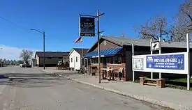 Moe's Bar and Grill and City Hall in New Underwood. | |
 Location in Pennington County and the state of South Dakota | |
| Coordinates: 44°5′38″N 102°50′3″W | |
| Country | United States |
| State | South Dakota |
| County | Pennington |
| Area | |
| • Total | 1.45 sq mi (3.75 km2) |
| • Land | 1.45 sq mi (3.75 km2) |
| • Water | 0.00 sq mi (0.00 km2) |
| Elevation | 2,844 ft (867 m) |
| Population | |
| • Total | 660 |
| • Estimate (2019)[3] | 673 |
| • Density | 464.78/sq mi (179.40/km2) |
| Time zone | UTC-7 (Mountain (MST)) |
| • Summer (DST) | UTC-6 (MDT) |
| ZIP code | 57761 |
| Area code(s) | 605 |
| FIPS code | 46-45060[4] |
| GNIS feature ID | 1256685[5] |
| Website | www |
New Underwood got its start circa 1906.[7] The city was named for John Underwood, a cattleman.[8]
Geography
New Underwood is located at 44°5′38″N 102°50′3″W (44.093843, -102.834055).[9]
According to the United States Census Bureau, the city has a total area of 1.00 square mile (2.59 km2), all land.[10]
New Underwood has been assigned the ZIP code 57761 and the FIPS place code 45060.
Demographics
| Historical population | |||
|---|---|---|---|
| Census | Pop. | %± | |
| 1910 | 134 | — | |
| 1920 | 164 | 22.4% | |
| 1930 | 311 | 89.6% | |
| 1940 | 214 | −31.2% | |
| 1950 | 268 | 25.2% | |
| 1960 | 462 | 72.4% | |
| 1970 | 416 | −10.0% | |
| 1980 | 517 | 24.3% | |
| 1990 | 553 | 7.0% | |
| 2000 | 616 | 11.4% | |
| 2010 | 660 | 7.1% | |
| 2019 (est.) | 673 | [3] | 2.0% |
| U.S. Decennial Census[11] | |||
2010 census
As of the census[2] of 2010, there were 660 people, 248 households, and 162 families living in the city. The population density was 660.0 inhabitants per square mile (254.8/km2). There were 280 housing units at an average density of 280.0 per square mile (108.1/km2). The racial makeup of the city was 89.5% White, 6.4% Native American, 0.2% Asian, 0.8% from other races, and 3.2% from two or more races. Hispanic or Latino of any race were 2.7% of the population.
There were 248 households, of which 34.3% had children under the age of 18 living with them, 47.6% were married couples living together, 13.7% had a female householder with no husband present, 4.0% had a male householder with no wife present, and 34.7% were non-families. 28.6% of all households were made up of individuals, and 7.6% had someone living alone who was 65 years of age or older. The average household size was 2.47 and the average family size was 3.09.
The median age in the city was 39.9 years. 27.4% of residents were under the age of 18; 6.5% were between the ages of 18 and 24; 23.2% were from 25 to 44; 26.9% were from 45 to 64; and 16.1% were 65 years of age or older. The gender makeup of the city was 50.2% male and 49.8% female.
2000 census
As of the census[4] of 2000, there were 616 people, 232 households, and 174 families living in the city. The population density was 1,338.2 people per square mile (517.0/km2). There were 265 housing units at an average density of 575.7 per square mile (222.4/km2). The racial makeup of the city was 93.34% White, 5.84% Native American, and 0.81% from two or more races. Hispanic or Latino of any race were 1.14% of the population.
There were 232 households, out of which 40.1% had children under the age of 18 living with them, 53.4% were married couples living together, 14.2% had a female householder with no husband present, and 24.6% were non-families. 20.3% of all households were made up of individuals, and 11.6% had someone living alone who was 65 years of age or older. The average household size was 2.66 and the average family size was 3.02.
In the city, the population was spread out, with 31.3% under the age of 18, 6.2% from 18 to 24, 28.6% from 25 to 44, 20.0% from 45 to 64, and 14.0% who were 65 years of age or older. The median age was 34 years. For every 100 females, there were 97.4 males. For every 100 females age 18 and over, there were 94.9 males.
The median income for a household in the city was $32,750, and the median income for a family was $36,111. Males had a median income of $25,096 versus $21,442 for females. The per capita income for the city was $14,729. About 4.8% of families and 8.0% of the population were below the poverty line, including 6.5% of those under age 18 and 15.2% of those age 65 or over.
References
- "2019 U.S. Gazetteer Files". United States Census Bureau. Retrieved July 30, 2020.
- "U.S. Census website". United States Census Bureau. Retrieved 2012-06-21.
- "Population and Housing Unit Estimates". United States Census Bureau. May 24, 2020. Retrieved May 27, 2020.
- "U.S. Census website". United States Census Bureau. Retrieved 2008-01-31.
- "US Board on Geographic Names". United States Geological Survey. 2007-10-25. Retrieved 2008-01-31.
- Ullrich, Jan F. (2014). New Lakota Dictionary (2nd ed.). Bloomington, IN: Lakota Language Consortium. ISBN 978-0-9761082-9-0. Archived from the original on 2016-10-18. Retrieved 2014-02-12.
- Federal Writers' Project (1940). South Dakota place-names, v.1-3. University of South Dakota. p. 52.
- Chicago and North Western Railway Company (1908). A History of the Origin of the Place Names Connected with the Chicago & North Western and Chicago, St. Paul, Minneapolis & Omaha Railways. p. 132.
- "US Gazetteer files: 2010, 2000, and 1990". United States Census Bureau. 2011-02-12. Retrieved 2011-04-23.
- "US Gazetteer files 2010". United States Census Bureau. Archived from the original on 2012-01-25. Retrieved 2012-06-21.
- United States Census Bureau. "Census of Population and Housing". Retrieved November 8, 2014.
Municipalities and communities of Pennington County, South Dakota, United States | ||
|---|---|---|
| Cities | 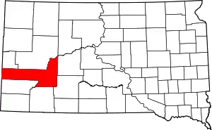 | |
| Towns | ||
| CDPs | ||
| Former CDP | ||
| Unincorporated communities | ||
| Ghost towns | ||
| Footnotes | ‡This populated place also has portions in an adjacent county or counties | |
| ||