Wall, South Dakota
Wall (Lakota: Makȟóšiča Aglágla Otȟuŋwahe,[6] "Town alongside the Badlands") is a town in Pennington County, South Dakota, United States. The population was 766 at the 2010 census.
Wall, South Dakota
Makȟóšiča Aglágla Otȟuŋwahe | |
|---|---|
 Wall Drug Store | |
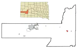 Location in Pennington County and the state of South Dakota | |
| Coordinates: 43.99°N 102.24°W | |
| Country | United States |
| State | South Dakota |
| County | Pennington |
| Incorporated | 1908[1] |
| Area | |
| • Total | 2.21 sq mi (5.74 km2) |
| • Land | 2.17 sq mi (5.61 km2) |
| • Water | 0.05 sq mi (0.12 km2) |
| Elevation | 2,825 ft (861 m) |
| Population | |
| • Total | 766 |
| • Estimate (2019)[4] | 875 |
| • Density | 403.97/sq mi (155.94/km2) |
| Time zone | UTC−7 (Mountain (MST)) |
| • Summer (DST) | UTC−6 (MDT) |
| ZIP code | 57790 |
| Area code(s) | 605 |
| FIPS code | 46-68380 |
| GNIS feature ID | 1262653[5] |
| Website | https://www.wallsd.us/ |
History
Wall was platted in 1907 when the Chicago and North Western Railroad was extended to that point.[7] The town was incorporated in 1908.[8] Wall was for the "natural wall" in rock formations by the Badlands National Park.[9]
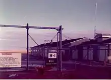
The town is most famous for the Wall Drug Store, which opened as a small pharmacy in 1931 during the Depression, but eventually developed into a large roadside tourist attraction.[10]
The National Grasslands Visitor Center is also located in Wall.
Geography
Wall is located at 43.99°N 102.24°W.[11]
According to the United States Census Bureau, the town has a total area of 2.22 square miles (5.75 km2), of which 2.17 square miles (5.62 km2) is land and 0.05 square miles (0.13 km2) is water.[12]
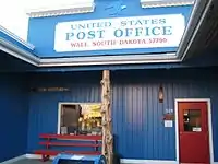
Wall has been assigned the ZIP code 57790 and the FIPS place code 68380.
Demographics
| Historical population | |||
|---|---|---|---|
| Census | Pop. | %± | |
| 1910 | 167 | — | |
| 1920 | 224 | 34.1% | |
| 1930 | 326 | 45.5% | |
| 1940 | 500 | 53.4% | |
| 1950 | 556 | 11.2% | |
| 1960 | 629 | 13.1% | |
| 1970 | 786 | 25.0% | |
| 1980 | 770 | −2.0% | |
| 1990 | 834 | 8.3% | |
| 2000 | 818 | −1.9% | |
| 2010 | 766 | −6.4% | |
| 2019 (est.) | 875 | [4] | 14.2% |
| U.S. Decennial Census[13] | |||
2010 census
At the 2010 census there were 766 people, 359 households, and 212 families in the town. The population density was 353.0 inhabitants per square mile (136.3/km2). There were 436 housing units at an average density of 200.9 per square mile (77.6/km2). The racial makeup of the town was 88.9% White, 0.1% African American, 7.0% Native American, 0.1% Asian, and 3.8% from two or more races. Hispanic or Latino of any race were 1.0%.[3]
Of the 359 households 21.7% had children under the age of 18 living with them, 49.6% were married couples living together, 4.5% had a female householder with no husband present, 5.0% had a male householder with no wife present, and 40.9% were non-families. 39.6% of households were one person and 18.1% were one person aged 65 or older. The average household size was 2.13 and the average family size was 2.82.
The median age in the town was 47.1 years. 21.4% of residents were under the age of 18; 7.4% were between the ages of 18 and 24; 19.7% were from 25 to 44; 31.8% were from 45 to 64; and 19.6% were 65 or older. The gender makeup of the town was 50.4% male and 49.6% female.
2000 census
At the 2000 census, there were 818 people, 349 households, and 212 families residing in Wall. The population density was 404.2 people per square mile (156.4/km2). There were 438 housing units at an average density of 216.4 per square mile (83.7/km2). The racial makeup of the town was 91.44% White, 0.24% African American, 6.11% Native American, 0.12% Asian, 0.49% Pacific Islander, 0.24% from other races, and 1.34% from two or more races. Hispanics or Latinos of any race were 0.73% of the population.
Of the 349 households 28.1% had children under the age of 18 living with them, 51.3% were married couples living together, 7.2% had a female householder with no husband present, and 39.0% were non-families. 35.0% of households were one person and 16.6% were one person aged 65 or older. The average household size was 2.31 and the average family size was 3.03.
The age distribution was 25.9% under 18, 7.9% from 18 to 24, 20.5% from 25 to 44, 27.5% from 45 to 64, and 18.1% who were 65 or older. The median age was 42 years. For every 100 females, there were 88.9 males. For every 100 females age 18 and over, there were 91.8 males.
The median household income was $36,563, and the median family income was $45,417. Males had a median income of $29,286 versus $19,821 for females. The per capita income for the town was $20,848. About 5.8% of families and 8.7% of the population were below the poverty line, including 13.4% of those under age 18 and 12.8% of those age 65 or over.
References
- "SD Towns" (PDF). South Dakota State Historical Society. Retrieved 2010-02-17.
- "2019 U.S. Gazetteer Files". United States Census Bureau. Retrieved July 30, 2020.
- "U.S. Census website". United States Census Bureau. Retrieved 2012-06-21.
- "Population and Housing Unit Estimates". United States Census Bureau. May 24, 2020. Retrieved May 27, 2020.
- "US Board on Geographic Names". United States Geological Survey. 2007-10-25. Retrieved 2008-01-31.
- Ullrich, Jan F. (2011). New Lakota Dictionary (2nd ed.). Bloomington, IN: Lakota Language Consortium. p. 1140. ISBN 978-0-9761082-9-0.
- Hellmann, Paul T. (14 February 2006). Historical Gazetteer of the United States. Routledge. p. 1000. ISBN 1-135-94859-3.
- "Wall, South Dakota". City-Data.com. Retrieved August 5, 2012.
- Federal Writers' Project (1938). A South Dakota Guide. WPA. p. 290. ISBN 978-0-403-02190-1.
- Let's Go Inc. (31 March 2009). Roadtripping USA. St. Martin's Press. p. 264. ISBN 978-0-312-38583-5.
- "US Gazetteer files: 2010, 2000, and 1990". United States Census Bureau. 2011-02-12. Retrieved 2011-04-23.
- "US Gazetteer files 2010". United States Census Bureau. Retrieved 2012-06-21.
- United States Census Bureau. "Census of Population and Housing". Retrieved September 21, 2013.
External links
| Wikivoyage has a travel guide for Wall, South Dakota. |
| Wikimedia Commons has media related to Wall, South Dakota. |
Municipalities and communities of Pennington County, South Dakota, United States | ||
|---|---|---|
| Cities | 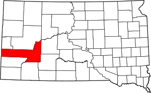 | |
| Towns | ||
| CDPs | ||
| Former CDP | ||
| Unincorporated communities | ||
| Ghost towns | ||
| Footnotes | ‡This populated place also has portions in an adjacent county or counties | |
| ||

| Authority control |
|---|