Niles Township, Floyd County, Iowa
Niles Township is one of twelve townships in Floyd County, Iowa, USA. As of the 2000 census, its population was 533.[1]
Niles Township | |
|---|---|
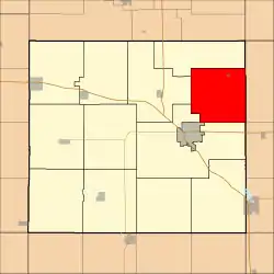 Location in Floyd County | |
| Coordinates: 43°07′25″N 92°36′47″W | |
| Country | |
| State | |
| County | Floyd |
| Area | |
| • Total | 34.6 sq mi (89.62 km2) |
| • Land | 34.6 sq mi (89.62 km2) |
| • Water | 0 sq mi (0 km2) 0% |
| Elevation | 1,033 ft (315 m) |
| Population (2000) | |
| • Total | 533 |
| • Density | 15.4/sq mi (5.9/km2) |
| Time zone | UTC-6 (CST) |
| • Summer (DST) | UTC-5 (CDT) |
| ZIP codes | 50616, 50645 |
| GNIS feature ID | 0468442 |
Geography
According to the United States Census Bureau, Niles Township covers an area of 34.6 square miles (89.62 square kilometers).
Cities, towns, villages
Unincorporated towns
- Doubleday at 43.086362°N 92.633521°W
- Nilesville at 43.140528°N 92.613519°W
(This list is based on USGS data and may include former settlements.)
Adjacent townships
- Deerfield Township, Chickasaw County (east)
- Chickasaw Township, Chickasaw County (southeast)
- Saint Charles Township (southwest)
- Floyd Township (west)
- Cedar Township (northwest)
Cemeteries
The township contains Beckwith Cemetery.
Landmarks
- Colwell County Park
School districts
- Charles City Community School District
Political districts
- Iowa's 4th congressional district
- State House District 14
- State Senate District 7
References
- United States Census Bureau 2008 TIGER/Line Shapefiles
- United States Board on Geographic Names (GNIS)
- United States National Atlas
- "U.S. Census website". Retrieved 2009-05-15.
External links
Places adjacent to Niles Township, Floyd County, Iowa | |
|---|---|
Municipalities and communities of Floyd County, Iowa, United States | ||
|---|---|---|
| Cities | Map of Iowa highlighting Floyd County | |
| Townships | ||
| CDP | ||
| Other unincorporated communities | ||
| Footnotes | ‡This populated place also has portions in an adjacent county or counties | |
| ||
This article is issued from Wikipedia. The text is licensed under Creative Commons - Attribution - Sharealike. Additional terms may apply for the media files.
