Nong Bua Daeng District
Nong Bua Daeng (Thai: หนองบัวแดง, pronounced [nɔ̌ːŋ būa̯ dɛ̄ːŋ]) is a district (amphoe) of Chaiyaphum Province, northeastern Thailand.
Nong Bua Daeng
หนองบัวแดง | |
|---|---|
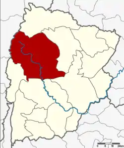 District location in Chaiyaphum Province | |
| Coordinates: 16°4′54″N 101°48′12″E | |
| Country | Thailand |
| Province | Chaiyaphum |
| Seat | Nong Bua Daeng |
| Area | |
| • Total | 2,215.5 km2 (855.4 sq mi) |
| Population (2000) | |
| • Total | 92,766 |
| • Density | 41.9/km2 (109/sq mi) |
| Time zone | UTC+7 (ICT) |
| Postal code | 36210 |
| Geocode | 3605 |
History
The district was established as a minor district (king amphoe) on 16 July 1965, when the two tambons Nong Bua Daeng and Nang Daet were split off from Kaset Sombun District.[1] It was upgraded to a full district on 1 April 1969.[2]
Geography
Neighboring districts are (from the north clockwise): Khon San District, Kaset Sombun, Mueang Chaiyaphum, Ban Khwao, Nong Bua Rawe, and Phakdi Chumphon of Chaiyaphum Province; and Nong Phai and Mueang Phetchabun of Phetchabun Province.
Administration
The district is divided into eight subdistricts (tambons), which are further subdivided into 130 villages (mubans). There is one municipality (thesaban), and eight tambon administrative organizations (TAO).
| 1. | Nong Bua Daeng | หนองบัวแดง | |
| 2. | Kut Chum Saeng | กุดชุมแสง | |
| 3. | Tham Wua Daeng | ถ้ำวัวแดง | |
| 4. | Nang Daet | นางแดด | |
| 7. | Nong Waeng | หนองแวง | |
| 8. | Khu Mueang | คูเมือง | |
| 9. | Tha Yai | ท่าใหญ่ | |
| 11. | Wang Chomphu | วังชมภู |
Missing numbers are now tambons of Phakdi Chumphon District.
References
- ประกาศกระทรวงมหาดไทย เรื่อง แบ่งท้องที่ตั้งเป็นกิ่งอำเภอ (PDF). Royal Gazette (in Thai). 82 (57 ง): 1878. July 20, 1965.
- พระราชกฤษฎีกาจัดตั้งอำเภอสมเด็จ อำเภอสีชมพู อำเภอหนองบัวแดง อำเภอบ้านแท่น อำเภอดอนตูม อำเภอนากลาง อำเภอศรีบุญเรือง และอำเภอป่าติ้ว พ.ศ. ๒๕๑๒ (PDF). Royal Gazette (in Thai). 86 (16 ก): 225–229. February 25, 1969.