Phetchabun Province
Phetchabun (Thai: เพชรบูรณ์, pronounced [pʰét.t͡ɕʰā.būːn]) is one of Thailand's seventy-six provinces (changwat) lies in lower northern Thailand. Neighbouring provinces are (from north clockwise) Loei, Khon Kaen, Chaiyaphum, Lopburi, Nakhon Sawan, Phichit, and Phitsanulok.
Phetchabun
เพชรบูรณ์ | |
|---|---|
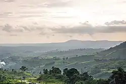 Khao Kho National Park at sundown | |
 Flag  Seal | |
| Nickname(s): Mueang Makham Wan (city of sweet tamarinds) | |
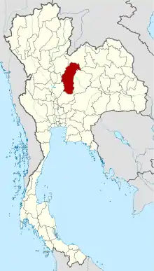 Map of Thailand highlighting Phetchabun Province | |
| Coordinates: 16°20′N 101°06′E | |
| Country | Thailand |
| Capital | Phetchabun |
| Government | |
| • Governor | Phibun Hatthakitkoson (since October 2016) |
| Area | |
| • Total | 12,668 km2 (4,891 sq mi) |
| Area rank | Ranked 9th |
| Population (2018)[2] | |
| • Total | 994,540 |
| • Rank | Ranked 22nd |
| • Density | 79/km2 (200/sq mi) |
| • Density rank | Ranked 63rd |
| Human Achievement Index | |
| • HAI (2017) | 0.6239 "somewhat high" Ranked 16th |
| Time zone | UTC+7 (ICT) |
| Postal code | 67xxx |
| Calling code | 056 & 043 |
| ISO 3166 code | TH-67 |
| Website | www |
Geography and climate
Phetchabun is in the lower northern region of Thailand, in the area between the northern and the central region. The province lies in the broad fertile river valley of the Pa Sak River, with mountains of the Phetchabun mountain range to the east and west.
Khao Kho National Park, Nam Nao National Park, and Tat Mok National Park are all in the province, either entirely or partially.
Phetchabun especially Khao Kho is a place with good weather and cold all year round. Therefore received the nickname "Switzerland of Thailand".[4]
Toponymy
The word phetcha originates from the Sanskrit word vajra meaning "diamond" (or weapon of Indra), and the word bun from Sanskrit purna meaning "full", "perfect" or "whole". Hence the name of the province literally means "perfect diamond".
Initially, the province was called "Phe-cha-buth" as "Phuenchapura", which means the city that has plenty of crops.[5] The reason is that the province is very fertile and has ample resources. Because of the fertility of the land, Phetchabun has always been agriculturally productive area.
History
Phetchabun was established by two kingdoms: the Sukhothai Kingdom, and the Ayutthaya Period of the King Narai.
In the Thesaphiban administrative reforms at the beginning of the 20th century, the province, together with Lom Sak Province to the north, formed monthon Phetchabun. As it was the smallest monthon, it was also the first monthon to be dissolved in 1915, after being temporarily administered from Monthon Phitsanulok between 1903 and 1907. Lom Sak Province was abolished and merged into Phetchabun in 1932.
During the period between 1968-1982 communist insurgents established bases in the mountains in the province. From hidden locations they fought occasional skirmishes against the Thai Army.
Symbols
The provincial seal shows a diamond on a mountain, as diamonds are found in the province. In the foreground are tobacco plants, as it is one of the crops grown in the province. The provincial tree is the tamarind. Craspedacusta sowerbyi, a rare species of freshwater jellyfish is the provincial aquatic animal. Because Phetchabun is one of the few places in the world, that is the habitat of this species of invertebrates.[6]
Economy
Tourism is considered the main industry of the province.
Phu Thap Boek, the highest mountain in the province. It is a well-known tourist destination and the largest cabbage growing place in the country.[7]
Transport
Road
Phetchabun is 346 kilometres from Bangkok by using Route 1 and Route 21.
Air
Phetchabun is served by Phetchabun Airport. Nok Air serves the airport with flights to Bangkok.[8]
Administrative divisions
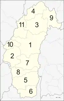
The province is divided into 11 districts (amphoe). These are further divided into 117 subdistricts (tambon) and 1261 villages (muban).
Local government
As of 26 November 2019 there are:[9] one Phetchabun Provincial Administration Organisation (ongkan borihan suan changwat) and 25 municipal (thesaban) areas in the province. Phetchabun, Wichian Buri and Lom Sak have town (thesaban mueang) status. Further 22 subdistrict municipalities (thesaban tambon). The non-municipal areas are administered by 102 Subdistrict Administrative Organisations - SAO (ongkan borihan suan tambon).[2]
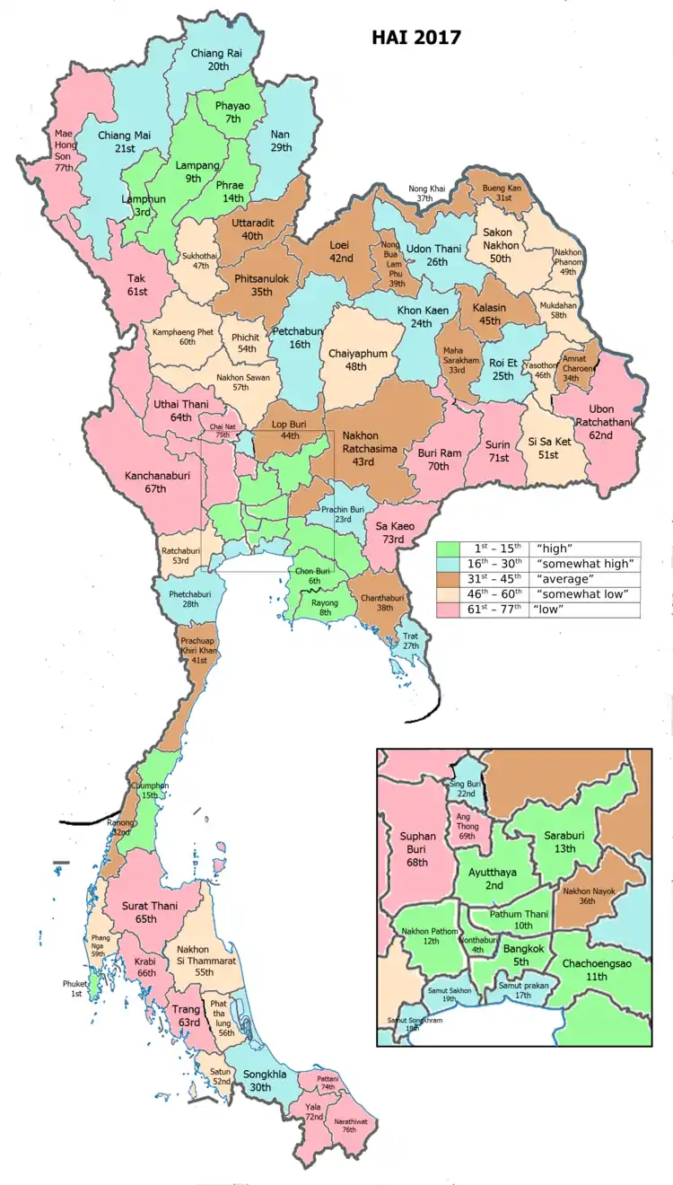
Human achievement index 2017
| Health | Education | Employment | Income |
| 35 | 49 | 39 | 14 |
| Housing | Family | Transport | Participation |
 |
 |
||
| 18 | 24 | 43 | 14 |
| Province Phetchabun, with an HAI 2017 value of 0.6239 is "somewhat high", occupies place 16 in the ranking. | |||
Since 2003, United Nations Development Programme (UNDP) in Thailand has tracked progress on human development at sub-national level using the Human achievement index (HAI), a composite index covering all the eight key areas of human development. National Economic and Social Development Board (NESDB) has taken over this task since 2017.[3]
| Rank | Classification |
| 1 - 15 | "high" |
| 16 - 30 | "somewhat high" |
| 31 - 45 | "average" |
| 45 - 60 | "somewhat low" |
| 61 - 77 | "low" |
| Map with provinces and HAI 2017 rankings |
 |

Local products
- Sweet tamarind
- Arabica coffee
- Khao lam
- Black galingale
- Stevia tea
- Thai vermicelli rice noodles
- Cabbage
- Grilled chicken
Notable people
- Saensak Muangsurin (b. 1950–2009), boxer
- Khaosai Galaxy (b. 1959), boxer, member of the International Boxing Hall of Fame
- Kaokor Galaxy (b. 1959), boxer
- Chana Porpaoin (b. 1966), boxer
- Songkram Porpaoin (b. 1966), boxer
- Sujin Naknayom (b. 1979), footballer
- Chakrit Buathong (b. 1985), footballer
- Sittisak Tarapan (b. 1984), footballer
Notes
Reports (data) from Thai government are "not copyrightable" (Public Domain), Copyright Act 2537 (1994), section 7.
References
- Advancing Human Development through the ASEAN Community, Thailand Human Development Report 2014, table 0:Basic Data (PDF) (Report). United Nations Development Programme (UNDP) Thailand. pp. 134–135. ISBN 978-974-680-368-7. Retrieved 17 January 2016, Data has been supplied by Land Development Department, Ministry of Agriculture and Cooperatives, at Wayback Machine.
- "รายงานสถิติจำนวนประชากรและบ้านประจำปี พ.ศ.2561" [Statistics, population and house statistics for the year 2018]. Registration Office Department of the Interior, Ministry of the Interior (in Thai). 31 December 2018. Retrieved 20 June 2019.
- Human achievement index 2017 by National Economic and Social Development Board (NESDB), pages 1-40, maps 1-9, retrieved 14 September 2019, ISBN 978-974-9769-33-1
- "เที่ยวเขาค้อ "สวิสเซอร์แลนด์เมืองไทย" แดนแห่งขุนเขาและทะเลหมอก ณ เมืองเพชรบูรณ์" [Travel to Khao Kho, "Switzerland of Thailand" land of mountains and sea of mist in Phetchabun]. Tong Tua Thai.com (in Thai).
- Thanarutleasakon, k. (2002). Pra – wat – tai – sart – Thai – ched– sib – hoke – jung -wat [Thai history of 76 provinces]. Bangkok : One World Publishing.
- "สัตว์น้ำประจำจังหวัดเพชรบูรณ์" [Provincal aquatic animal]. 4.fisheries.go.th (in Thai). 2018-02-11. Retrieved 2020-04-26.
- "กะหล่ำปลีสีเขียว ๆ ยังมีให้ดูที่ภูทับเบิก" [Green cabbages are also available at Phu Tub Berk]. Ch3 (in Thai). 2017-03-28. Retrieved 2020-04-26.
- https://www.routesonline.com/news/38/airlineroute/279004/nok-air-adds-phetchabun-from-june-2018/
- "Number of local government organizations by province". dla.go.th. Department of Local Administration (DLA). 26 November 2019. Retrieved 10 December 2019.
38 Phetchabun: 1 PAO, 3 Town mun., 22 Subdistrict mun., 102 SAO.
External links
 Phetchabun travel guide from Wikivoyage
- Phetchabun Tourist information
- Website of Province (Thai)
- Maps & attractions in Phetchabun
Places adjacent to Phetchabun Province | |
|---|---|