North Aral Sea
The North Aral Sea (Kazakh: Солтүстік Арал теңізі, Russian: Северное Аральское море) is the portion of the former Aral Sea that is fed by the Syr Darya River. It split from the South Aral Sea in 1987–1988[2] as water levels dropped due to river diversion for agriculture. The poorly built Dike Kokaral intended to contain the North Aral Sea and save its fisheries failed twice, but in 2005, the government of Kazakhstan was able to fund a more robust design. Since then, water levels have risen faster than expected and fish stocks have increased. Plans to build a second dike to increase water levels further were due to begin in 2010, but have so far not materialized.
| North Aral Sea | |
|---|---|
 North Aral Sea  North Aral Sea | |
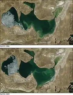 April 2005 and April 2006 comparisons | |
| Location | Kazakhstan, Central Asia |
| Coordinates | 46.5°N 60.7°E |
| Type | endorheic, natural lake, reservoir |
| Native name | Kazakh: Солтүстік Арал теңізі |
| Primary inflows | Syr Darya (previously also the Amu Darya) |
| Basin countries | Kazakhstan |
| Surface area | 3,300 km2 (1,270 sq mi) (2008) 2,550 km2 (985 sq mi) (2003) |
| Max. depth | 30 m (98 ft) (2003) 42 m (138 ft) (2008) |
| Official name | Lesser Aral Sea and Delta of the Syrdarya River |
| Designated | 2 February 2012 |
| Reference no. | 2083[1] |
Background
The Aral Sea began shrinking in the 1960s, when the Soviet Union decided that the two rivers feeding it, the Amu Darya and the Syr Darya, would be diverted to irrigate cotton and food crops in Kazakhstan and Uzbekistan. In 1987–1988,[2] due to an accelerated loss of water, the Aral Sea split into northern and southern parts; the southern part is the current South Aral Sea.
Salinity
There is now an ongoing effort in Kazakhstan to save and replenish the North Aral Sea. As part of this effort, a dam project was completed in 2005; in 2008, the water level in this lake had risen by 12 m (39 ft) from its level in 2003.[3] Salinity has dropped, and fish are again found in sufficient numbers for some fishing to be viable, especially mackerel introduced at the Syr Darya river delta, though attempts to introduce tuna in 2009 failed.
Current situation
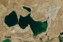
After the fall of the Soviet Union, the government of independent Kazakhstan decided to restore the northern lake fed by Syr Darya. In 2003, the lake was 30 m (98 ft) in depth and 2,550 km2 (985 sq mi) in area[3] (JAXA source: 3,200 km2 (1,240 sq mi));[4] by 2008 it had reached 42 m (138 ft) in depth and 3,300 km2 (1,270 sq mi) in area[3][5] (JAXA source: 3,600 km2 (1,390 sq mi)).[4]
See also
References
- "Lesser Aral Sea and Delta of the Syrdarya River". Ramsar Sites Information Service. Retrieved 25 April 2018.
- Micklin, Philip; Aladin, N.V.; Plotnikov, Igor, eds. (2014). The Aral Sea: The Devastation and Partial Rehabilitation of a Great Lake. Berlin, Heidelberg: Springer Berlin Heidelberg. doi:10.1007/978-3-642-02356-9. ISBN 978-3-642-02355-2.
- Environment News Service – The Kazakh Miracle: Recovery of the North Aral Sea
- JAXA – South Aral Sea shrinking but North Aral Sea expanding
- The rehabilitation of the ecosystem and bioproductivity of the Aral Sea under conditions of water scarcity (rev. August 2007)
- Philip Micklin, N.V. Aladin, Igor Plotnikov (22 November 2013). " The Aral Sea: The Devastation and Partial Rehabilitation of a Great Lake.CS1 maint: uses authors parameter (link)