Norwich City railway station
Norwich City railway station was located in Norwich, England and is now closed.[1]
Norwich City | |
|---|---|
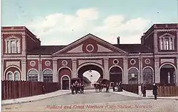
 Station in the early 1900s. | |
| Location | Norwich, Norwich England |
| Coordinates | 52.63445°N 1.28768°E |
| Platforms | 4 |
| Other information | |
| Status | Disused |
| History | |
| Original company | Lynn and Fakenham Railway |
| Pre-grouping | Midland and Great Northern Joint Railway |
| Post-grouping | Midland and Great Northern Joint Railway Eastern Region of British Railways |
| Key dates | |
| 2 Dec 1882 | Opened |
| 2 Mar 1959 | Closed to passengers |
| 1969 | Closed to freight |
Norwich Branch | |||||||||||||||||||||||||||||||||||||||||||||||||||||||||||||||||||||||||||||||||||||||||||
|---|---|---|---|---|---|---|---|---|---|---|---|---|---|---|---|---|---|---|---|---|---|---|---|---|---|---|---|---|---|---|---|---|---|---|---|---|---|---|---|---|---|---|---|---|---|---|---|---|---|---|---|---|---|---|---|---|---|---|---|---|---|---|---|---|---|---|---|---|---|---|---|---|---|---|---|---|---|---|---|---|---|---|---|---|---|---|---|---|---|---|---|
| |||||||||||||||||||||||||||||||||||||||||||||||||||||||||||||||||||||||||||||||||||||||||||
History

The station was opened in 1882 by the Lynn and Fakenham Railway,[2] and later became the southern terminus of the Midland and Great Northern Joint Railway (MG&N) line from Melton Constable. The station became well-used, with services to Cromer and through-carriages to a range of destinations including Peterborough and Leicester.
The station was badly bombed in the Baedeker raids of 1942 [3] when the main building was largely destroyed. The station was further damaged, along with St Philips Church, when a badly damaged USAF B24 Liberator bomber was deliberately crashed there to avoid greater loss of life. Thereafter, the station operated from "temporary" buildings constructed on the site. It was closed to passengers on 2 March 1959 along with most of the Midland & Great Northern system, although the station remained in use for goods traffic until 1969.
Location
The old Norwich City station stood where today's roundabout is situated on the Inner link road A147 which links Barn Road with St Crispins Road close to Anglia Square.[4][5]
Recent news and developments
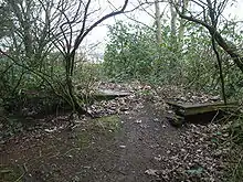
The amateur group Friends of Norwich City Station (FONCS) has been set up to preserve what is left of the station and surrounding buildings. Current work is focused on the platform area. The Platform 1 wall has been discovered and the bay area has been cleared of undergrowth. The hope for the future is to uncover all the railway related parts to the area and turn it into a memorial garden. They are also documenting all those who served the station. Interpretation boards will be erected, some illustrating old photographs of the site. M&GN benches are hoped to also accompany these.[6]
Former services
| Preceding station | Disused railways | Following station | ||
|---|---|---|---|---|
| Terminus | Midland and Great Northern Norwich Branch |
Hellesdon |
See also
References
- British Railways Atlas.1947. p.18
- Butt, R. V. J. (1995). The Directory of Railway Stations: details every public and private passenger station, halt, platform and stopping place, past and present (1st ed.). Sparkford: Patrick Stephens Ltd. ISBN 978-1-85260-508-7. OCLC 60251199.
- Norfolk history Retrieved 23 April 2011
- Norwich Evening News 24
- http://www.peterboggis.co.uk/Cycle_rides/Cyclemap3btext.jpeg
- News report Retrieved 23 April 2011
| Wikimedia Commons has media related to Norwich City railway station. |