Nuffield, Oxfordshire
Nuffield is a village and civil parish in the Chiltern Hills in South Oxfordshire, England, just over 4 miles (6 km) east of Wallingford. The 2011 Census recorded the parish population as 939.[1]
| Nuffield | |
|---|---|
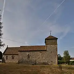 Holy Trinity parish church, seen from the north | |
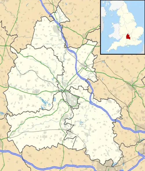 Nuffield Location within Oxfordshire | |
| Area | 12.91 km2 (4.98 sq mi) |
| Population | 939 (2011 Census) |
| • Density | 73/km2 (190/sq mi) |
| OS grid reference | SU6687 |
| Civil parish |
|
| District | |
| Shire county | |
| Region | |
| Country | England |
| Sovereign state | United Kingdom |
| Post town | Henley-on-Thames |
| Postcode district | RG9 |
| Dialling code | 01491 |
| Police | Thames Valley |
| Fire | Oxfordshire |
| Ambulance | South Central |
| UK Parliament | |
| Website | Nuffield Parish Council |
Early history
The ancient Ridgeway path runs through the village. The section of the Ridgeway west of the village follows the ancient Grim's Ditch, which is a Scheduled Ancient Monument.[2]
The earliest known records that refer to Nuffield by name are from the early decades of the 13th century, when episcopal registers variously record the toponym as Togfelde, Toufeld or Tofelde. The ecclesiastical valuation prepared in AD 1254 by Walter Suffield, Bishop of Norwich for Pope Innocent IV records it as Todfeld. A feudal aid prepared in 1428 records it as Tuffeld. At a later date the first letter changed from T to N to create the modern form of the name. The name comes from Old English, possibly hōh-feld meaning "field by a spur of hill".[3]
Parish church
The oldest parts of the Church of England parish church of the Holy Trinity are Norman.[4] They include the baptismal font and some of the masonry in the south wall of the nave.[4] Around the bowl of the font is a Latin inscription in Lombardic capitals.[5] In the 14th century the church was rebuilt and the north aisle was added.[4] In the 15th century a ceiling with moulded wooden beams and carved wooden bosses was inserted in the nave.[5]
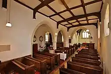
In 1845 the chancel was restored and the Gothic tracery in all the windows was replaced, to designs by Gothic Revival architect Benjamin Ferrey.[4] The church is a Grade II* listed building.[5]
Economic and social history
The road between Henley-on-Thames and Wallingford passes through the parish just north of Nuffield. It was made into a turnpike in 1736 and ceased to be a turnpike in 1873.[6] It is now classified the A4130.
Huntercombe Place is an Edwardian Tudor-style house designed by Oswald Milne, a former assistant to the Arts and Crafts Movement architect Edwin Lutyens and completed in 1910.[4] Huntercombe Place is now part of HMYOI Huntercombe.
Nuffield Place is a house that was completed in 1914. Lord Nuffield had it enlarged in 1933 and lived there until his death in 1963. He was buried at the parish church, and bequeathed Nuffield Place and its contents to Nuffield College, Oxford as a museum. The college has gifted the house and part of the estate to the National Trust.[7][8]
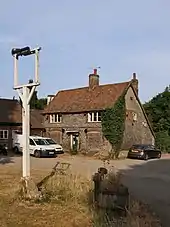
There was a 17th-century pub in the parish, The Crown,[9] on the A4130 main road at Nuffield Common. By September 2016 it had ceased trading and its freehold was for sale.[10]
Amenities
Huntercombe Golf Club is in the parish.[11]
The Ridgeway is now a long-distance footpath. Another long-distance footpath, the Chiltern Way, passes through the northern part of the parish.
Thames Travel bus route X38 links Nuffield with Wallingford and Oxford in one direction and Henley and Reading, Berkshire in the other. It stops on the A4130 main road between Nuffield Place and The Crown former pub. Buses run generally hourly from Mondays to Saturdays. There is no Sunday service.[12]
References
- "Area: Nuffield CP (Parish): Key Statistics: Population Density". Neighbourhood Statistics. Office for National Statistics. Retrieved 18 March 2010.
- Historic England. "Grim's Ditch; portion from Mongewell Park Lodge to S of Nuffield church (1006368)". National Heritage List for England. Retrieved 26 July 2018.
- Ekwall 1960, Nuffield
- Sherwood & Pevsner 1974, p. 724
- Historic England. "Church of the Holy Trinity (Grade II*) (1059326)". National Heritage List for England. Retrieved 22 July 2018.
- Rosevear, Alan. "Turnpike Roads in England".
- "Nufffield Place". National Trust. 22 July 2018.
- "`". National Trust Magazine. National Trust: 34–38. Summer 2011.
- Historic England. "The Crown Public House (Grade II) (1059323)". National Heritage List for England. Retrieved 22 July 2018.
- "The Crown (Freehold)" (PDF). Caldecotte Group. Retrieved 22 July 2018.
- Huntercombe Golf Club
- "river rapids X38 X39 X40" (PDF). Thames Travel. Retrieved 22 July 2018.
Sources
- Ekwall, Eilert (1960) [1936]. Concise Oxford Dictionary of English Place-Names (4th ed.). Oxford: Oxford University Press. Nuffield. ISBN 0198691033.
- Sherwood, Jennifer; Pevsner, Nikolaus (1974). Oxfordshire. The Buildings of England. Harmondsworth: Penguin Books. p. 724. ISBN 0-14-071045-0.
External links
| Wikimedia Commons has media related to Nuffield, Oxfordshire. |