Nurmijärvi
Nurmijärvi (Finnish pronunciation: [ˈnurmiˌjærʋi]) is the most populated rural municipality of Finland, located 37 kilometres (23 mi) north of the capital Helsinki. The neighboring municipalities of Nurmijärvi are Espoo, Vantaa, Tuusula, Hyvinkää and Vihti, and it is part of the Greater Helsinki. The population of the municipality is 43,403 inhabitants.[7] In recent decades, it has been one of the fastest growing municipalities in the Greater Helsinki and also in whole Finland in terms of population; even the 2020 COVID-19 pandemic hasn't shown a slowdown in growth of population.[8]
Nurmijärvi | |
|---|---|
Municipality | |
| Nurmijärven kunta Nurmijärvi kommun | |
 | |
 Coat of arms | |
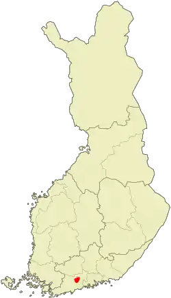 Location of Nurmijärvi in Finland | |
| Coordinates: 60°28′N 024°48.5′E | |
| Country | |
| Region | Uusimaa |
| Sub-region | Helsinki sub-region |
| Charter | 1605 |
| Government | |
| • Municipal manager | Outi Mäkelä[1] |
| Area (2018-01-01)[2] | |
| • Total | 367.26 km2 (141.80 sq mi) |
| • Land | 361.84 km2 (139.71 sq mi) |
| • Water | 5.4 km2 (2.1 sq mi) |
| Area rank | 211th largest in Finland |
| Population (2020-07-31)[3] | |
| • Total | 43,403 |
| • Rank | 26th largest in Finland |
| • Density | 119.95/km2 (310.7/sq mi) |
| Population by native language | |
| • Finnish | 97.1% (official) |
| • Swedish | 1.2% |
| • Others | 1.7% |
| Population by age | |
| • 0 to 14 | 23.9% |
| • 15 to 64 | 65.3% |
| • 65 or older | 10.8% |
| Time zone | UTC+02:00 (EET) |
| • Summer (DST) | UTC+03:00 (EEST) |
| Municipal tax rate[6] | 19% |
| Climate | Dfb |
| Website | www.nurmijarvi.fi |
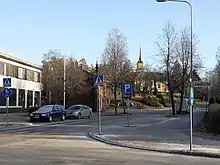
The close proximity to Helsinki has led to a considerable growth of the major villages such as Klaukkala, Rajamäki and Röykkä. Klaukkala is the biggest built-up area of Nurmijärvi, which nowadays is considered a dormitory town of Helsinki. The church village (Kirkonkylä) is the administrative centre of the municipality, although the clear emphasis on population growth is in Klaukkala.
Nurmijärvi literally means "lawn lake" although the lake that gave the municipality its name was drained in the early 20th century and is now nothing more than some flat fields near the village centre. Nurmijärvi is one of three municipalities in the Uusimaa region that do not have a Swedish name; the others are Askola and Mäntsälä.
Matti Vanhanen, former Prime Minister of Finland and current finance minister, lives in Lepsämä in Nurmijärvi.
History
.jpg.webp)
The area of what is now Nurmijärvi was inhabited in prehistoric times, which refers to archaeological finds dating back to 4500–3500 BC. At the time of the Middle Ages there was no permanent settlement in the area, but later the settlement spread from both Tavastia and the coast to 15 villages in 1540 with 115 houses.[9]
Administratively, Lake Nurmijärvi has been formed by combining the districts of Loppi, Vihti and Helsinki parish. The earliest documentary mention of Nurmijärvi dates back to 1488, when the village of Uotila was mentioned. According to the land register of 1539, Nurmijärvi had 15 villages with a total of 113 houses. An independent congregation had already been formed in 1605 and the administrator of Nurmijärvi was born in 1775, when the area had a population of 1471.[9]
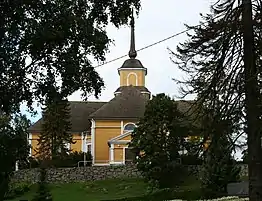
The first church in Lake Nurmijärvi, which must have been St. Martin's Church in 1565, was built at the end of the Middle Ages. It was demolished on the way to a new church, completed in 1692, and the present church, completed in 1793 and designed by master builder Matti Åkerblom, is the third in order.[10]
Lake Nurmijärvi has long been a strong farmer, and the share of fields in the total municipal area is almost one third, which is more than in many other municipalities in Finland. Horticultural crops have also been heavily cultivated and, for example, almost half of the wild cabbage harvest in Finland is produced in Nurmijärvi. Nevertheless, the municipality has not carried out further processing of agricultural products; for example, there has been no dairy.[10]
The first industrial plants were born in the late 19th century, including Finland's first pharmaceutical factory founded by pharmacist Albin Koponen in Nurmijärvi in 1899.[9] The main products of the drug plant were filizine extracted from male fern root rhizomes, which were sold as Diphyllobothrium latum and cestoda medicines called Filisin and Filicon. The factory-produced filicin was sold encapsulated all the way to China]] and America. Today, trade, transport and other services account for two thirds, industry and construction for less than one third and agriculture for over 3% of the population. The largest individual employers are Altia Oyj[9] and Teknos Oy in Rajamäki, Polimoon Oy in Klaukkala and Korsisaari Oy.
In the early 1960s, the settlement of Nurmijärvi was evenly distributed in different parts of the municipality. However, migration to Nurmijärvi began to accelerate around the middle of the decade and the focus of settlement shifted to the southern parts of the municipality. Already in 1970 the majority (65%) of the inhabitants of Nurmijärvi lived in urban settlements. The largest agglomerations at that time were Klaukkala (3,500 inhabitants), Rajamäki (3,400 inhabitants) and church village (2,800 inhabitants). Of these, the growth of Klaukkala and church village, in particular, has been based almost exclusively on the vicinity of the Helsinki metropolitan area.[9][10] The most prominent farms on Lake Nurmijärvi have been the manors of Numlahti and Raala. Before the departure of Hyvinkää in 1917, the Kytäjä Manor as well as the whole of the Kytäjä village, were part of the Nurmijärvi parish.[9]
Geography
_beach.jpg.webp)
Nurmijärvi is located in the central part of Uusimaa. Salpausselkä passes through the northern part of the municipality via Röykkä, Kiljava and Rajamäki, and the River Vantaa flows through the Nukari and Palojoki rivers in the eastern part of the municipality. Nurmijärvi's lowest terrain is in the Luhtajoki valley at Klaukkala and the highest in Salpausselkä near Herunen.
There are few watercourses in the Nurmijärvi area. The municipality is located along the middle course of the River Vantaa and there are two large rapids, the Nukarinkoski and the Myllykoski. The River Vantaa is joined by the Palojoki River from Hyvinkää and Tuusula, near the Palojoki village. The Lepsämä River and the Luhtajoki River flowing in the southern part of the municipality join the Vantaa town side near the Keimola village before joining the River Vantaa. The largest lake in Nurmijärvi is the Lake Sääksi (which is partly situated on the northwest side of Hyvinkää), which is known for one of the most popular beaches in Finland,[11] being located in the Kiljava village. The other lakes are Lake Vaaksi near Röykkä and Lake Valkjärvi between Klaukkala and Perttula.
Villages
Herunen, Järventausta, Kiljava, Klaukkala, Leppälampi, Lepsämä, Luhtajoki, Metsäkylä, Nukari, Numlahti, Nummenpää, Nurmijärvi (Kirkonkylä), Palojoki, Perttula, Raala, Rajamäki, Röykkä, Suomies, Uotila, Valkjärvi
Transport
The most important traffic route through Nurmijärvi is Finnish national road 3 (Vt 3) between cities of Helsinki and Tampere. The highway was built as a motorway in the 1990s, and the old highway next to it between Helsinki and Hämeenlinna was numbered as Regional Road 130. Highway 3 is joined by Finnish national road 45 (Kt 45) on the Hyvinkää side from Hyrylä in Tuusula and through the eastern part of Nurmijärvi, and Finnish national road 25 (Vt 25) between Hanko and Porvoo passes through the northern part of the municipality near the Röykkä village. Other important roads are the Regional road 132 to Loppi and Karkkila via Klaukkala, Perttula and Röykkä and the connecting road 1311 to Rajamäki via the Nurmijärvi church village. The Hanko–Hyvinkää railway, which currently has only freight train traffic, also passes through Rajamäki and Röykkä.[10] In Nurmijärvi, especially from Klaukkala, there are frequent bus services via Kivistö and Keimola of Vantaa to the Central Bus Terminal of Kamppi Center in Helsinki.[12]
With the growth of Klaukkala, traffic congestion between Regional road 132 and Highway 3 has worsened so much over the years that the construction of a bypass road on the northside of Klaukkala as a new continuation of the regional road began in 2019.[13] Although it was tentatively scheduled to be completed only in fall 2021, it is likely to be completed in summer and for traffic road may open as early as the end of 2020.[14]
Government
The municipality of Nurmijärvi belongs to the Uusimaa constituency. Nurmijärvi Municipal Council has 51 members; the chairman of the municipal board is Virpi Räty and the municipal council is Kallepekka Toivonen. The current municipal manager of Nurmijärvi is Outi Mäkelä; the previous manager, Kimmo Behm, retired on 1 May 2018.[1]
Politics
Results[15] of the 2019 Finnish parliamentary election in Nurmijärvi:
- Finns Party 20.1%
- National Coalition Party 19.4%
- Social Democratic Party 15.3%
- Centre Party 14.6%
- Green League 11.3%
- Movement Now 5.9%
- Left Alliance 4%
- Blue Reform 3.2%
- Christian Democrats 2.7%
- Other parties 3.5%
Services
The only hotel in the municipality for tourists, Hotel Kiljava, is located in the village of Kiljava.[16][17]
Culture
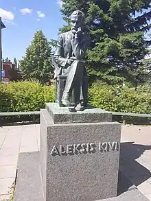
Nurmijärvi is best known as the birthplace of Finland's national author, Aleksis Kivi. The coat of arms of municipality refers to his most famous literal work, Seitsemän veljestä (literally translated "the seven brothers") from 1870. Every year, the municipality hosts the Kivi Festival (Kivi-juhlat), the main venue of which is the Taaborinvuori museum area next to Aleksis Kivi's birthplace. On January 29, 2020, Nurmijärvi declared itself officially the Capital of Aleksis Kivi.[18]
Food
In the 1980s, the cultural dishes of Nurmijärvi parish were called pastries with raisin soup, a roast beef cured slowly in mild heat, berry cream and sweetened potato casserole.[19]
Notable people
- Bernhard Crusell (1775–1838), a composer
- Ellen Jokikunnas (born 1976), a model and PR manager
- Antti J. Jokinen (born 1968), a music video and film director
- Antti Kalliomäki (born 1947), a politician and athlete
- Dome Karukoski (born 1976), a film director
- Aleksis Kivi (1834–1872), an author and playwright
- Jussi Niinistö (born 1970), a politician and a former Minister of Defence
- Viivi Pumpanen (born 1988), Miss Finland 2010
- Teemu Rautiainen (born 1992), a professional ice hockey player
- Aki Sirkesalo (1962–2004), a singer and broadcaster
- Matti Vanhanen (born 1955), a politician, former Prime Minister of Finland and current Minister of Finance
- Waldo (born 1967), Eurodance musician
Friendship cities
 Lilla Edet, Sweden
 Rapla, Estonia
References
- Outi Mäkelä valittiin Nurmijärven uudeksi kunnanjohtajaksi (in Finnish)
- "Area of Finnish Municipalities 1.1.2018" (PDF). National Land Survey of Finland. Retrieved 30 January 2018.
- "Suomen virallinen tilasto (SVT): Väestön ennakkotilasto [verkkojulkaisu]. Heinäkuu 2020" (in Finnish). Statistics Finland. Retrieved 13 September 2020.
- "Population according to language and the number of foreigners and land area km2 by area as of 31 December 2008". Statistics Finland's PX-Web databases. Statistics Finland. Retrieved 29 March 2009.
- "Population according to age and gender by area as of 31 December 2008". Statistics Finland's PX-Web databases. Statistics Finland. Retrieved 28 April 2009.
- "List of municipal and parish tax rates in 2011". Tax Administration of Finland. 29 November 2010. Retrieved 13 March 2011.
- 11lj -- Väestörakenteen ennakkotiedot alueittain, 2019M01*-2019M11* (in Finnish)
- Miten kävi Nurmijärvi-ilmiön korona aikaan? –Hyvin, sanoo kunnan selvitys – Maaseudun Tulevaisuus, 20 August 2020 (in Finnish)
- "Nurmijärven historiaa lyhyesti". Nurmijarvi.fi (in Finnish). Retrieved February 22, 2020.
- Hannu Tarmio, Pentti Papunen & Kalevi Korpela: Suomenmaa 5: maantieteellis-yhteiskunnallinen tieto- ja hakuteos, p. 405–406. Porvoo-Helsinki: WSOY, 1973.
- Suomen 10 upeinta uimarantaa – pulahda täällä kesälomareissulla (in Finnish)
- Kamppi to Klaukkala - 4 ways to travel via train, taxi, bus, and car|Rome2rio
- YLE: Yli 30 vuotta Klaukkalan ohikulkutietä on odotettu – tänään hanke viimein käynnistyi (in Finnish)
- Klaukkalan ohikulkutie liikenteelle ehkä jo vuoden lopussa – työt edenneet hyvin. (in Finnish)
- "Tulospalvelu: Eduskuntavaalit 2019 - Nurmijärvi". Nurmijärven uutiset. Retrieved April 15, 2019.
- Hotel Kiljavanranta - Kiljava, Nurmijärvi, Finland
- "Hotel Kiljava uudistuu vaudilla – tulossa jousiammuntaa ja monia muita aktiviteetteja" (in Finnish). Nurmijärven Uutiset. August 8, 2020. Retrieved August 8, 2020.
- Laine, Riikka (January 29, 2020). "Nurmijärvi on nyt virallisesti Aleksis Kivi pääkaupunki". Nurmijärven Uutiset (in Finnish). Retrieved January 30, 2020.
- Kolmonen, Jaakko 1988. Kotomaamme ruoka-aitta: Suomen, Karjalan ja Petsamon pitäjäruoat, s. 59. Helsinki: Patakolmonen Ky. (in Finnish)
External links
![]() Media related to Nurmijärvi at Wikimedia Commons
Media related to Nurmijärvi at Wikimedia Commons
- Municipality of Nurmijärvi – Official site
| Municipalities |  | |
|---|---|---|
| Former municipalities |
| |
50 most populous municipalities in Finland (city or town status marked in bold) | ||||||||||||||||||||||||||||||||||||||||||||||||||||||||||||||||||||||||||||||||||||||||||||||||
|---|---|---|---|---|---|---|---|---|---|---|---|---|---|---|---|---|---|---|---|---|---|---|---|---|---|---|---|---|---|---|---|---|---|---|---|---|---|---|---|---|---|---|---|---|---|---|---|---|---|---|---|---|---|---|---|---|---|---|---|---|---|---|---|---|---|---|---|---|---|---|---|---|---|---|---|---|---|---|---|---|---|---|---|---|---|---|---|---|---|---|---|---|---|---|---|---|
| ||||||||||||||||||||||||||||||||||||||||||||||||||||||||||||||||||||||||||||||||||||||||||||||||