Obi Islands
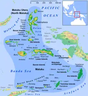
The Obi Islands (also known as Ombirah,[1] Indonesian: Kepulauan Obi) are a group of islands in the Indonesian province of North Maluku. They lie north of Buru and Ceram. They cover a land area of 2,823.43 km2, and had a population of 41,455 at the 2010 Census,[2] which had risen to about 46,080 by 2018.[3]
| Native name: Kepulauan Obi | |
|---|---|
 | |
 | |
| Geography | |
| Location | Southeast Asia |
| Major islands | Obi Island |
| Administration | |
| Province | North Maluku |
| Demographics | |
| Languages | Galela, Tobelo |
| Additional information | |
| Time zone | |
Geography
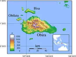
Obi Island, or also called Obira Island, is the largest island in the Obi Islands archipelago. Obi Island is surrounded by many small islands, including Obilatu Island, Bisa Island, Gata-gata Island, Latu Island, Woka Island, and Tomini Island. Obi Island is bordered by the Maluku Sea to the west, the Seram Sea to the south, and the Obi Strait to the north and east. The major islands closest to Obi Island are Bacan Island to the north and Ambon to the south. The topography of Obi Island is generally in the form of hills with a short coastline. The hilly surface conditions result in many springs and rivers. Lake Kapi, in the west, is the largest lake on Obi Island.
Administration
Obi Island is part of South Halmahera Regency. It is directly bordered by Maluku Province in the south and West Papua Province in the east. The total area of the island is about 2,500 square kilometres (970 sq mi). Obi Island and the surrounding small islands are divided into five administrative districts (kecamatan), and each district is divided into 34 administrative villages (desa and kelurahan), with villages further subdivided into hamlets.
Demographics
The population of the Obi Islands Group is approximately 46,000 people (in 2018)[4], with a population density of 16.3 people per square kilometer, per Indonesian Department of Population and Civil Registry data for South Halmahera in 2010. All inhabitants on the Obi Island are migrants, as these islands had no indigenous population. The first groups to settle on Obi Island were the Buton, followed by immigrants from Tobelo-Galela, Ternate, Tidore, Makian-Kayoa, Bugis, Makassar and Java. Almost all of the residents are scattered along the coast with the highlands mostly uninhabited jungle. However, there are some worker settlements in hilly areas which have mines and temporary settlements for clove farmers used during clove harvesting season. Infrastructure, especially in terms of modern medical facilities, is lacking.
The languages spoken on the islands are Galela and Tobelo, which belong to the West Papuan language family.
Economy
The dominant plantation products in the Obi Islands are cloves, nutmeg, coconut and pepper. The main economic potential of the islands s in the mining sector. The island has resources of gold, coal, nickel, cement, and petroleum. In 2016, provincial governor Abdul Ghani Kasuba successfully negotiated for the China-based Jinchun Group to build a nine-trillion rupiah nickel smelter on the main island.[5]
Notes
- Goodall, George (Editor)(1943) Philips' International Atlas London, George Philip and Son map 'East Indies' pp.91-92
- Biro Pusat Statistik, Jakarta, 2011.
- Badan Pusat Statistik, Jakarta, 2020.
- Badan Pusat Statistik, Jakarta, 2020.
- China`s Jinchun to in vest Rp9 trillion in North Maluku. Antara, 16 July 2016. Accessed 18 September 2017.
| Wikimedia Commons has media related to Obi Islands. |