South Halmahera Regency
South Halmahera Regency (Indonesian: Kabupaten Halmahera Selatan) is a regency of North Maluku Province, Indonesia. It lies partly on Halmahera Island and partly on smaller islands to the west and south of Halmahera. It covers a land area of 8,148.90 km2, and at the 2010 Census it had a population of 198,911 people,[2] while the 2015 Intermediate Census showed that this had risen to 219,559;[3] the latest official estimate (as at mid 2018) is 228,771.[4] The capital lies at Labuha on Bacan Island.
South Halmahera Regency
Kabupaten Halmahera Selatan | |
|---|---|
 Coat of arms | |
| Motto(s): Saruma | |
| Coordinates: 0.3955°S 127.9083°E | |
| Country | |
| Province | |
| Capital | Labuha |
| Government | |
| • Regent | Bahrain Kasuba |
| • Vice Regent | Iswan Hasjim |
| Area | |
| • Total | 8,148.90 km2 (3,146.31 sq mi) |
| Population (2018) | |
| • Total | 228,771 |
| • Density | 28/km2 (73/sq mi) |
| [1] | |
| Time zone | UTC+9 (IEST) |
| Area code | (+62) 927 |
| Website | halselkab.go.id |
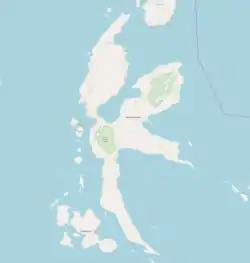

Islands
Besides the southern part of Halmahera Island, the Regency includes a number of archipelagoes and islands. Among them:
- Obi Islands, including Obira (main), Bisa, Obilatu and other small islands, comprising in all five kecamatan with 46,081 people in 2018.
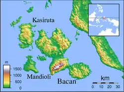
- Bacan Islands, including:
- Kayoa Group, comprising 4 kecamatan with 21,928 people
- Makian, comprising 2 kecamatan with 13,599 people
- Joronga Islands, comprising 1 kecamatan with 5,688 people, including the southern tip of Halmahera Island
- the southern peninsula of Halmahera Island (the area is known as Gane), comprising 6 kecamatan with 39,221 people.[5]
Administration
The Regency is divided into thirty districts (kecamatan), tabulated below with their areas and their 2010 Census populations,[6] together with the official estimated populations in mid 2018:[7] The table also includes the name of the administrative centre and the number of administrative villages (desa and kelurahan) in each district and its post code.
| Name | English name | Area in km2 | Population Census 2010 | Population Estimate mid 2018[8] | Admin. Centre | No. of vill. | Post code | Island or Group |
|---|---|---|---|---|---|---|---|---|
| Obi Selatan | South Obi | 1,020.02 | 12,128 | 13,100 | Wayaloar | 8 | 97792 | Obi Islands |
| Obi | 985.69 | 14,125 | 16,472 | Laiwui | 9 | 97792 | Obi Islands | |
| Obi Barat | West Obi | 88.98 | 3,586 | 3,943 | Jikohai | 6 | 97792 | Obi Islands |
| Obi Timur | East Obi | 586.23 | 3,389 | 3,669 | Sum | 4 | 97792 | Obi Islands |
| Obi Utara | North Obi | 142.51 | 8,227 | 8,897 | Madopolo | 7 | 97792 | Obi Islands |
| Bacan Timur Selatan | Southeast Bacan | 329.42 | 6,460 | 7,262 | Wayaua | 7 | 97791 | Bacan Islands |
| Bacan Timur Tengah | East Central Bacan | 236.29 | 5,229 | 6,120 | Bibinoi | 7 | 97791 | Bacan Islands |
| Bacan Timur | East Bacan | 424.33 | 9,051 | 11,792 | Babang | 10 | 97791 | Bacan Islands |
| Bacan Selatan | South Bacan | 141.60 | 13,265 | 16,954 | Mandaong | 10 | 97791 | Bacan Islands |
| Bacan | 288.75 | 19,092 | 25,524 | Labuha | 14 | 97791 | Bacan Islands | |
| Bacan Barat Utara | Northwest Bacan | 239.95 | 4,096 | 4,739 | Yaba | 8 | 97791 | Bacan Islands |
| Bacan Barat | West Bacan | 173.97 | 3,549 | 3,918 | Indari | 7 | 97791 | Bacan Islands |
| Kepulauan Batanglomang | Batang Lomang Islands | 50.38 | 6,177 | 6,657 | Bajo | 8 | 97790 | Batang Lomang Islands |
| Mandioli Selatan | South Mandioli | 130.97 | 5,798 | 6,334 | Jiko | 6 | 97791 | Mandioli |
| Mandioli Utara | North Mandioli | 85.36 | 2,990 | 3,495 | Indong | 6 | 97791 -97792 | Mandioli |
| Kasiruta Timur | East Kasiruta | 217.71 | 3,847 | 4,420 | Loleo Jaya | 8 | 97790 | Kasiruta |
| Kasiruta Barat | West Kasiruta | 261.33 | 4,521 | 5,039 | Palamea | 10 | 97790 | Kasiruta |
| Kayoa Barat | West Kayoa | 24.74 | 3,469 | 3,797 | Busua | 4 | 97781 | Kayoa Islands |
| Kayoa | 77.54 | 8,180 | 8,853 | Guruapin | 14 | 97780 | Kayoa Islands | |
| Kayoa Selatan | South Kayoa | 23.29 | 5,856 | 6,283 | Laluin | 6 | 97780 | Kayoa Islands |
| Kayoa Utara | North Kayoa | 34.12 | 2,671 | 2,995 | Laromabati | 6 | 97781 | Kayoa Islands |
| Makian Barat | West Makian | 33.47 | 3,417 | 3,859 | Mateketen | 7 | 97784 | Makian |
| Pulau Makian | Makian Island | 50.89 | 8,977 | 9,740 | Kota | 15 | 97785 | Makian |
| Gane Barat Utara | Northwest Gane | 441.86 | 6,027 | 6,503 | Dolik | 12 | 97789 | Halmahera |
| Gane Barat | West Gane | 532.53 | 7,972 | 8,496 | Saketa | 10 | 97782 | Halmahera |
| Gane Barat Selatan | Southwest Gane | 203.19 | 5,545 | 6,336 | Gane Dalam | 8 | 97782 | Halmahera |
| Kepulauan Joronga | Joronga Islands | 127.12 | 5,264 | 5,688 | Kakupang | 7 | 97786 | Joronga Islands |
| Gane Timur Selatan | Southeast Gane | 289.83 | 3,478 | 3,842 | Gane Luar | 5 | 97787 | Halmahera |
| Gane Timur Tengah | East Central Gane | 302.47 | 3,796 | 4,356 | Bisui | 8 | 97788 | Halmahera |
| Gane Timur | East Gane | 602.42 | 8,729 | 9,688 | Maffa | 12 | 97783 | Halmahera |
Economy
South Halmahera has been designated by provincial governor Abdul Ghani Kasuba as a region for tourism development.[9] The Widi International Fishing Tournament was founded for this purpose.[10] Kasuba also successfully negotiated for the China-based Jinchun Group to build a nine-trillion rupiah nickel smelter in the Obi Islands.[11]
References
- Badan Pusat Statistik, Jakarta, 2020.
- Biro Pusat Statistik, Jakarta, 2011.
- Badan Pusat Statistik, Jakarta, 2019.
- Badan Pusat Statistik, Jakarta, 2020.
- http://www.halmaheraselatankab.go.id/index.php?option=com_content&view=article&id=152:penduduk-halsel&catid=62:penduduk&Itemid=41
- Biro Pusat Statistik, Jakarta, 2011.
- Badan Pusat Statistik, Jakarta, 2020.
- Badan Pusat Statistik, Jakarta, 2020.
- Widi Islands to be the Future of North Maluku Tourism. Tempo, 21 May 2017. Accessed 18 September 2017.
- Aria Cindyara, N Maluku to boost maritime sector through fishing tourism. Antara, 24 August 2017. Accessed 30 August 2017.
- China`s Jinchun to in vest Rp9 trillion in North Maluku. Antara, 16 July 2016. Accessed 18 September 2017.
Externe links
- "Profil Kabupaten Halmahera Selatan [Profile South Halmahera Regency]" (PDF). RPI2-JMI Kabupaten Halmahera Selatan, Bantuan Teknis RPI2JM Dalam Implementasi Kebijakan Keterpaduan Program Bidang Cipta Karya – Provinsi Maluku Utara (in Indonesian). 2014.
Regencies and cities of North Maluku | ||
|---|---|---|
Capital: Sofifi | ||
| Regencies | ||
| Cities | ||
