Pamukkale
Pamukkale, meaning "cotton castle" in Turkish, is a natural site in Denizli Province in southwestern Turkey. The area is famous for a carbonate mineral left by the flowing of thermal spring water.[1][2] It is located in Turkey's Inner Aegean region, in the River Menderes valley, which has a temperate climate for most of the year.
| UNESCO World Heritage Site | |
|---|---|
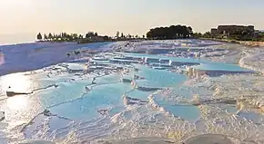 Panoramic view of travertine terraces at Pamukkale | |
| Official name | Hierapolis-Pamukkale |
| Location | Denizli Province, Turkey |
| Criteria | Cultural and Natural: (iii)(iv)(vii) |
| Reference | 485 |
| Inscription | 1988 (12th session) |
| Area | 1,077 ha (4.16 sq mi) |
| Website | www |
| Coordinates | 37°55′26″N 29°07′24″E |
 Location of Pamukkale in Turkey | |
The ancient Greco-Roman city of Hierapolis was built on top of the travertine formation which is in total about 2,700 metres (8,860 ft) long, 600 m (1,970 ft) wide and 160 m (525 ft) high. It can be seen from the hills on the opposite side of the valley in the town of Denizli, 20 km away. Known as Pamukkale (Cotton Castle) or ancient Hierapolis (Holy City), this area has been drawing visitors to its thermal springs since the time of Classical antiquity.[1] The Turkish name refers to the surface of the shimmering, snow-white limestone, shaped over millennia by calcite-rich springs.[2] Dripping slowly down the mountainside, mineral-rich waters collect in and cascade down the mineral terraces, into pools below. Legend has it that the formations are solidified cotton (the area's principal crop) that giants left out to dry.
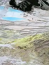
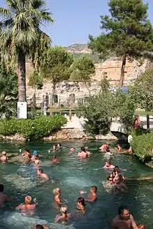
People have visited area for thousands of years, due to the attraction of the thermal pools.[1] As recently as the mid-20th century, hotels were built over the ruins of Hierapolis, causing considerable damage. An approach road was built from the valley over the terraces, and motor bikes were allowed to go up and down the slopes. When the area was declared a UNESCO World Heritage Site, the hotels were demolished and the road removed and replaced with artificial pools. There are well-preserved Roman ruins and a museum on site. A small footpath runs up the mountain face for visitors to use, however the travertine terraces are all off-limits, having suffered damage, erosion and water pollution due to tourism.
It was added as a UNESCO World Heritage Site in 1988 with Hierapolis.
Geology
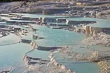
Pamukkale's terraces are made of travertine, a sedimentary rock deposited by mineral water from the hot springs.[1] In this area, there are 17 hot springs with temperatures ranging from 35 °C (95 °F) to 100 °C (212 °F). The water that emerges from the spring is transported 320 metres (1,050 ft) to the head of the travertine terraces and deposits calcium carbonate on a section 60 to 70 metres (200 to 230 ft) long covering an expanse of 24 metres (79 ft) to 30 metres (98 ft). When the water, supersaturated with calcium carbonate, reaches the surface, carbon dioxide de-gasses from it, and calcium carbonate is deposited. Calcium carbonate is deposited by the water as a soft gel which eventually crystallizes into travertine.
Archaeology
There are only a few historical facts known about the origin of the city. No traces of the presence of Hittites or Persians have been found. The Phrygians built a temple, probably in the first half of the 7th century BC. This temple, originally used by the citizens of the nearby town of Laodicea, would later form the centre of Hierapolis.
Hierapolis was founded as a thermal spa early in the 2nd century BC within the sphere of the Seleucid Empire. Antiochus the Great sent 2,000 Jewish families to Lydia and Phrygia from Babylon and Mesopotamia, later joined by more from Judea. The Jewish congregation grew in Hierapolis and has been estimated as high as 50,000 in 62 BC.[3] Hierapolis became a healing centre where doctors used the thermal springs as a treatment for their patients. The city began minting bronze coins in the 2nd century BC. These coins give the name Hieropolis. It remains unclear whether this name referred to the original temple (ἱερόν, hieron) or honoured Hiera, the wife of Telephus, son of Heracles and the Mysian princess Auge, the supposed founder of Pergamon's Attalid dynasty. This name eventually changed into Hierapolis ("holy city"),.[4] In 133 BC, when Attalus III died, he bequeathed his kingdom to Rome. Hierapolis thus became part of the Roman province of Asia. In AD 17, during the rule of the emperor Tiberius, a major earthquake destroyed the city.
Through the influence of the Christian apostle Paul, a church was founded here while he was at Ephesus.[5] The Christian apostle Philip spent the last years of his life here.[6] The town's Martyrium was alleged to have been built upon the spot where Philip was crucified in AD 80. His daughters were also said to have acted as prophetesses in the region.[7][8] During the 4th century, the Christians filled Pluto's Gate (a ploutonion) with stones, suggesting that Christianity had become the dominant religion and begun displacing other faiths in the area. Originally a see of Phrygia Pacatiana,[9] the Byzantine emperor Justinian raised the bishop of Hierapolis to the rank of metropolitan in 531. The Roman baths were transformed to a Christian basilica. During the Byzantine period, the city continued to flourish and also remained an important centre for Christianity.
Museum
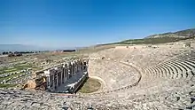
The museum contains historical artifacts from Hierapolis, as well as those from Laodiceia, Colossae, Tripolis, Attuda and other towns of the Lycos (Çürüksu) valley. The museum also has a section devoted to artifacts found at Beycesultan Hüyük that includes examples of Bronze Age craft.
Artifacts from the Caria, Pisidia and Lydia regions are also on display. The museum's exhibition space consists of three closed areas of the Hierapolis Bath and the open areas in the eastern side which are known to have been used as the library and gymnasium. The artifacts in open exhibition space are mostly marble and stone. Hierapolis is broken down into ruins.
World heritage site
Pamukkale is recognized as a World Heritage Site together with Hierapolis. Hierapolis-Pamukkale was made a World Heritage Site in 1988.[2] It is a tourist attraction due to this status and its natural beauty.
The underground volcanic activity which causes the hot springs also forced carbon dioxide into a cave, which was called the Plutonium, which here means "place of the god Pluto". This cave was used for religious purposes by priests of Cybele, who found ways to appear immune to the suffocating gas.
Protecting the thermal waters
The hotels built in the 1960s were demolished as they were draining the thermal waters into their swimming pools and caused damage to the terraces. The water supply to the hotels is restricted in an effort to preserve the overall site and to allow deposits to regenerate.[10]
Access to the terraces is not allowed and visitors are asked to follow the pathway.[10]
Similar places
These locations are also well known for their travertine formations:
- Egerszalók in Hungary
- Badab-e Surt in Iran
- Mammoth Hot Springs in the USA
- Pink and White Terraces in New Zealand[11][12]
- Hierve el Agua in Mexico[13]
- Bagni San Filippo (Siena)
- Baishuitai in China
- Tatev, Armenia
- Terme di Saturnia in Italy
- Huanglong Scenic and Historic Interest Area, A similar UNESCO world heritage travertine cascade in China.
Notes
- Scheffel, Richard L.; Wernet, Susan J., eds. (1980). Natural Wonders of the World. United States of America: Reader's Digest Association, Inc. p. 286. ISBN 978-0-89577-087-5.
- "Hierapolis-Pamukkale World Heritage Site". UNESCO World Heritage Centre. Retrieved 2007-06-23.
- Padfield.com. "Jewish Congregation in Hierapolis".
- Kevin M. Miller (July 1985). "Apollo Lairbenos". Numen. 32 (1): 46–70. doi:10.1163/156852785X00157. JSTOR 3269962.
- Colossians 4:13.
- Papias. Early Christian Writings Archived 2015-09-24 at the Wayback Machine.
- "NPNF2-01. Eusebius Pamphilius: Church History, Life of Constantine, Oration in Praise of Constantine - Christian Classics Ethereal Library". www.ccel.org. Archived from the original on 4 May 2018. Retrieved 4 May 2018.
- "NPNF2-01. Eusebius Pamphilius: Church History, Life of Constantine, Oration in Praise of Constantine - Christian Classics Ethereal Library". www.ccel.org. Archived from the original on 14 October 2017. Retrieved 4 May 2018.
- RAMSAY, Cities and Bishoprics of Phrygia (Oxford, 1895–1897)
- Pamukkale Travetines Denizli
- Bunn, Rex; Nolden, Sascha (2017-06-07). "Forensic cartography with Hochstetter's 1859 Pink and White Terraces survey: Te Otukapuarangi and Te Tarata". Journal of the Royal Society of New Zealand. 0: 39–56. doi:10.1080/03036758.2017.1329748. ISSN 0303-6758. S2CID 134907436.
- Bunn and Nolden, Rex and Sascha (December 2016). "Te Tarata and Te Otukapuarangi: Reverse engineering Hochstetter's Lake Rotomahana Survey to map the Pink and White Terrace locations". Journal of New Zealand Studies. NS23: 37–53.
- Hasnain I, Iqra A. "Hierve el Agua | A flowing Cascade". NaturesRim. Retrieved 2020-07-21.
External links
| Wikimedia Commons has media related to Pamukkale. |
- Pamukkale official site
 Pamukkale travel guide from Wikivoyage
- Pamukkale - spherical panorama 360 degree
- UNESCO World Heritage site datasheet
- The Marble Stairs of Heaven on Earth: Pamukkale
- Pamukkale Travel Guide
- Photos and first hand account of visit including Hierapolis and Cleopatra's pool
- Visiting the Cotton Castle – Geobeats.com on Youtube
- Video from Pamukkale (4k, UltraHD)
| Aegean |
|
|---|---|
| Black Sea |
|
| Central Anatolia |
|
| East Anatolia |
|
| Marmara |
|
| Mediterranean |
|
| Southeastern Anatolia |
|
| |
