Panama City, Florida
Panama City is a city and the county seat of Bay County, Florida, United States.[6] Located along U.S. Route 98, it is the largest city between Tallahassee and Pensacola. It is the more populated of two principal cities of the Panama City-Lynn Haven, Florida Metropolitan Statistical Area. As of the 2010 census, the population was 36,484.[7] Panama city was catastrophically damaged when Hurricane Michael made landfall as a Category 5 hurricane on October 10, 2018. When Panama City was incorporated in 1909, its original city limits were 15th Street (Hwy 98) on the north, Balboa Avenue on the west and Bay Avenue on the east.
Panama City, Florida | |
|---|---|
| City of Panama City | |
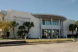 Top: Panama City's Old city hall in November 2013, prior to Hurricane Michael. | |
 Flag  Seal | |
 Location in Bay County and the U.S. state of Florida | |
 Panama City, Florida Location in the United States | |
| Coordinates: 30°10′28″N 85°39′52″W | |
| Country | |
| State | |
| County | |
| Incorporated | 1909 |
| Named for | Panama City, Panama |
| Government | |
| • Mayor | Greg Brudnicki (D)[1] |
| Area | |
| • City | 41.17 sq mi (106.62 km2) |
| • Land | 35.02 sq mi (90.69 km2) |
| • Water | 6.15 sq mi (15.93 km2) |
| • Metro | 1,312 sq mi (3,400 km2) |
| Elevation | 26 ft (8 m) |
| Population (2010) | |
| • City | 36,484 |
| • Estimate (2019)[3] | 34,667 |
| • Density | 990.00/sq mi (382.24/km2) |
| • Metro | 202,236 |
| Time zone | UTC-6 (Central (CST)) |
| • Summer (DST) | UTC-5 (CDT) |
| Zip Codes | 32401–32409, 32411–32413, 32417, 32461 |
| Area code(s) | 850 |
| FIPS code | 12-54700[4] |
| GNIS feature ID | 0288448[5] |
| Website | www.pcgov.org |
Name
The development in this once unincorporated part of Northwest Florida had previous names such as Floriopolis, Park Resort, and Harrison.[8] In 1906, the development was named Panama City and it was first incorporated as Panama City in 1909. When Panama City was incorporated in 1909, its original city limits were 15th Street (Hwy 98) on the north, Balboa Avenue on the west and Bay Avenue on the east. According to the Panama City Public Library's A History of Panama City,[9] George Mortimer West hoped to spur real estate development in Bay County during a period of intense popular interest in the construction of the Panama Canal by changing the town's name from Harrison to Panama City, because a straight line between Chicago and the Central American country Panama's national capital intersected the Florida town. Additionally, since required meanders around land formations in a seaborne route to the canal added distance when starting at other ports, Panama City was the closest developed port in the US mainland to the Caribbean entrance of the Panama Canal.
Demographics
| Historical population | |||
|---|---|---|---|
| Census | Pop. | %± | |
| 1910 | 422 | — | |
| 1920 | 1,722 | 308.1% | |
| 1930 | 5,402 | 213.7% | |
| 1940 | 11,610 | 114.9% | |
| 1950 | 25,814 | 122.3% | |
| 1960 | 33,275 | 28.9% | |
| 1970 | 32,096 | −3.5% | |
| 1980 | 33,346 | 3.9% | |
| 1990 | 34,378 | 3.1% | |
| 2000 | 36,417 | 5.9% | |
| 2010 | 36,484 | 0.2% | |
| 2019 (est.) | 34,667 | [3] | −5.0% |
| U.S. Decennial Census[10] | |||
As of the census[4] of 2010, there were 36,484 people, 14,792 households, and 8,613 families residing in the city. The population density was 1,245.2 people per square mile (481.3/km2). There were 17,438 housing units at an average density of 595.2 per square mile (230.1/km2). As of the census[4] of 2010, the racial makeup of the city is 71.6% White, 22.0% African American, 1.6% Asian, 0.5% Native American, 0.1% Pacific Islander, 2.9% from two or more races, and 5.1% Hispanic or Latino of any race.
There were 14,792 households, out of which 23.6% had children under the age of 18 living with them, 36.3% were headed by married couples living together, 6.8% had a female householder with no husband present, and 41.8% were non-families. 34.1% of all households were made up of individuals, and 13.0% were someone living alone who was 65 years of age or older. The average household size was 2.28, and the average family size was 2.91.[7]
In the city, the population was 20.7% under the age of 18, 10.2% from 18 to 24, 25.9% from 25 to 44, 26.9% from 45 to 64, and 16.3% who were 65 years of age or older. The median age was 39.7 years. For every 100 females, there were 96.3 males. For every 100 females age 18 and over, there were 95.2 males.[7]
Geography
Panama City is located at 30°10′28″N 85°39′52″W (30.174451, -85.664480)[11] within the Florida Panhandle and along the Emerald Coast. According to the United States Census Bureau, the city limits encompass an area of 35.4 square miles (91.8 km2), of which 29.3 square miles (75.8 km2) is land and 6.2 square miles (16.0 km2), or 17.39%, is water.[12]
Climate
Panama City has a humid subtropical climate, with short, mild winters and long, hot and humid summers. In January, the average low is 42 °F (6 °C), and in July the average high is 90 °F (32 °C).
Due to its location on the Gulf Coast, the city is susceptible to tropical cyclones. In 2018, Panama City was directly hit by Hurricane Michael, which caused catastrophic damage to the city and surrounding communities, with winds of 160 mph (260 km/h) at landfall. The city previously suffered significant indirect impacts from Hurricane Ivan (2004) and Hurricane Opal (1995).
| Climate data for Panama City, FL | |||||||||||||
|---|---|---|---|---|---|---|---|---|---|---|---|---|---|
| Month | Jan | Feb | Mar | Apr | May | Jun | Jul | Aug | Sep | Oct | Nov | Dec | Year |
| Record high °F (°C) | 82.0 (27.8) |
82.4 (28.0) |
87.8 (31.0) |
91.0 (32.8) |
97.0 (36.1) |
100.4 (38.0) |
100.4 (38.0) |
100.4 (38.0) |
100.0 (37.8) |
98.6 (37.0) |
96.8 (36.0) |
82.4 (28.0) |
100.4 (38.0) |
| Average high °F (°C) | 63.3 (17.4) |
66.3 (19.1) |
71.6 (22.0) |
77.5 (25.3) |
84.4 (29.1) |
88.7 (31.5) |
90.1 (32.3) |
90.0 (32.2) |
88.2 (31.2) |
81.2 (27.3) |
73.0 (22.8) |
65.0 (18.3) |
78.3 (25.7) |
| Average low °F (°C) | 42.1 (5.6) |
46.3 (7.9) |
51.3 (10.7) |
57.4 (14.1) |
65.4 (18.6) |
72.7 (22.6) |
75.1 (23.9) |
74.8 (23.8) |
70.8 (21.6) |
60.4 (15.8) |
51.4 (10.8) |
44.2 (6.8) |
59.3 (15.2) |
| Record low °F (°C) | 7.2 (−13.8) |
25.2 (−3.8) |
25.9 (−3.4) |
37.9 (3.3) |
48.9 (9.4) |
48.9 (9.4) |
62.1 (16.7) |
63.0 (17.2) |
51.8 (11.0) |
36.0 (2.2) |
30.9 (−0.6) |
13.1 (−10.5) |
7.2 (−13.8) |
| Average precipitation inches (mm) | 4.89 (124) |
5.11 (130) |
5.68 (144) |
3.67 (93) |
3.08 (78) |
6.18 (157) |
7.39 (188) |
6.96 (177) |
6.03 (153) |
3.60 (91) |
4.47 (114) |
4.02 (102) |
61.1 (1,550) |
| Average rainy days | 9 | 8 | 8 | 5 | 5 | 8 | 13 | 13 | 9 | 5 | 7 | 8 | 98 |
| Average relative humidity (%) | 76.2 | 74.8 | 74.9 | 75.1 | 77.2 | 78.7 | 79.9 | 80.7 | 78.2 | 75.8 | 75 | 76 | 76.8 |
| Source: Florida Climate Center,[13] WeatherBase (days precipitation and humidity)[14] and Climatebase.ru (extremes)[15] | |||||||||||||
Time zone
Panama City is part of the Central Time Zone, unlike the city of Tallahassee to its east.
Economy
Personal income
As of the 2000 census, the city's median household income was $31,572, and the median income for a family was $40,890. Males had a median income of $30,401 versus $21,431 for females. The city's per capita income was $17,830. About 12.1% of families and 17.2% of the population were below the poverty line, including 24.5% of those under age 18 and 14.9% of those age 65 or over.
Industry

Two military bases make the federal government the largest employer. Other major industrial employers in the Bay County area include Eastern Shipbuilding Group, Gulf Power, WestRock, Trane, L-3 Communications, ARINC, and JENSEN-GROUP.[16]
Real estate
In 2006, Panama City was named the best place to invest in real estate in the US by CNN's Business 2.0 magazine.[17]
Military
Tyndall Air Force Base is east of the city. The HHT 1-153 CAV is stationed there. It is part of Florida Army National Guard's 53rd Infantry Brigade. The city is also home to the U.S. Navy's Naval Support Activity Panama City which is home to various research and training projects. The city is also 60-90 minutes south of Fort Rucker, Alabama, home to the US Army's Aviation Center of Excellence.
Retail
The city's main retail center was the Panama City Mall until it was permanently closed after Hurricane Michael. In August of 2020, Panama City Mall released the plans to the mall. The plans for the mall includes a hotel, shops, and restaurants. Another local retail center is the Bay City Pointe, on FL 368 (locally known as 23rd St.). Pier Park, on the beach across the Hathaway Bridge spanning St. Andrews Bay, is a third local retail center. Others retail areas in the Panama City Metro are the 15th Street Shopping Strip (A area between Harrison Ave/US Highway 231 and Beck Ave/US Bus 98/State Road 390), 23rd Street Shopping Strip, Downtown Panama City, Historic St. Andrews, and Millville Historic District.
Hospitals
The city has two hospitals, Ascension Sacred Heart Bay (known as Bay Medical Sacred Heart until Hurricane Michael destroyed a large portion of it) and Gulf Coast Medical Center.
Transportation
Major Highways
 US 98 (15th/ 18th St.)
 US 231
 SR 77 (Martin Luther King Jr. Blvd.)
 SR 390 (St. Andrews Blvd.)
 SR 368 (23rd St)
Roads
The two main east-to-west thoroughfares in Panama City proper are 23rd Street and U.S. Highway 98. FL-368 runs east-west across the northern part of the city as a bypass. U.S. Highway 98 runs east-west through the city itself, leading southeast 24 mi (39 km) to Mexico Beach and west 10 mi (16 km) to Panama City Beach.
The two main north-to-south thoroughfares in the city are Martin Luther King Boulevard, otherwise known as FL-77 and U.S. Highway 231. FL-77 leads north 6 mi (10 km) to the Panama City suburb of Lynn Haven. U.S. Highway 231 begins its national journey northward in the city, leading northeast 83 mi (134 km) to Dothan, Alabama.
Other more local highways run through the city, including many Bay County roads.
Bridges
Because of the city's position on St. Andrews Bay, bridges are very important to the area, and most directions into or out of the city require the use of one of three large bridges to cross parts of the bay. These are the Bailey Bridge to the north on Hwy 77, the Dupont Bridge to the south on Hwy 98 and the Hathaway Bridge to the west on Hwy 98. The largest of these is the Hathaway Bridge, which is the only direct connection between the beach side of Panama City, otherwise known as Panama City Beach .
Rail
The Bay Line Railroad has an 82-mile (132 km) rail line running north to Dothan, Alabama, to a connection with CSX Transportation and Norfolk Southern.
Bus transportation
Local transit is handled by the Baytown Trolley services.[18] Service generally runs Monday-Saturday from 6 AM to 7 PM.
Intercity transit is handled by the city's Greyhound station.[19]
Air transportation
The city was served by the Panama City-Bay County International Airport (PFN) until May 22, 2010. It was replaced by the Northwest Florida Beaches International Airport (ECP) with Southwest Airlines, Delta Air Lines, and United Airlines. In June 2018, ECP also added American Airlines.
Notable people
- Paula Barbieri, former model and actress; ex-girlfriend of O. J. Simpson
- Robert E. "Bob" Barton, former member of the Louisiana House of Representatives, graduated from Bay High School
- Blood Raw, rapper with the group U.S.D.A and Young Jeezy
- Mike Campbell, lead guitarist for Tom Petty and the Heartbreakers
- Jaye Chapman, pitcher with the Chicago Cubs
- Adam Cole, professional wrestler
- Donnie Craft, American player of gridiron football
- Clint Daniels, country music artist
- Clarence Earl Gideon, the plaintiff in Gideon v. Wainwright
- Herman Goldner, former mayor of St. Petersburg, lived in Panama City from 1991 to 1999
- David Herndon, pitcher with the New York Yankees
- Nathan Macias, Texas politician; former commander of the "Silver Flag", the USAF Civil Engineering Contingency Training Center at Tyndall Air Force Base[20]
- Bill Mazeroski, baseball Hall of Fame member
- Robert Lee McKenzie, entrepreneur, real estate developer, first mayor of Panama City, and an important figure in the early history of Bob Jones University
- Dan Peek, member of the soft rock band America
- Blake Percival, Whistleblower
- Kenny Saief, player for the United States men's national soccer team
- Anwar Stewart, defensive lineman, Montreal Alouettes of the Canadian Football League
- Ray Wilson, defensive back in the National Football League for the New Orleans Saints and Green Bay Packers
- Stacy Wilson, professional hockey player and coach
- William Witherspoon, 1998 graduate of Rutherford High School, linebacker in the National Football League
- Natalie Villalobos
Media
- The News Herald, newspaper
- WFSG, PBS affiliate on channel 56 (satellite of WFSU-TV, Tallahassee)
- WJHG, NBC affiliate on channel 7 (The CW & My Network TV digital)
- WMBB, ABC affiliate on channel 13
- WECP-LD, CBS affiliate on channel 18
- WPGX, Fox affiliate on channel 28
- Panama City Beach TV - Public-access television cable TV[21]
- WASJ, Bob FM 105.1, 1980s/1990s/2000s
- WBPC, Beach 95.1, Oldies
- WFLF-FM, Fox News Radio
- WFSW, public radio
- WFSY, adult contemporary
- WILN, Island 106, Contemporary hit radio
- WKGC and WKGC-FM, public radio
- WKNK, Kick'n Country, country
- WPAP, country
- WPFM, Hot 107.9, Contemporary hit radio
- WRBA, Classic Rock 95.9, Classic Rock
- WYOO, Talk Radio 101, Talk Radio
- WYYX, 97X, "Panama City's Rock Station"
- WAYP-FM, 88.3 WAY-FM Christian Hit Radio
Education
Panama City's public schools are operated by Bay District Schools. A system of charter schools, University Academy and Bay Haven Schools also services the Panama City area. Private schools in the city include, Holy Nativity Episcopal School, St. John Catholic School, Jacob Austin Prep. Academy, Covenant Christian School. Gulf Coast State College, formerly Gulf Coast Community College, is now a 4-year state college. Florida State University Panama City Campus and a satellite campus of Troy University are located in the city. Embry Riddle Aeronautical University has a satellite campus on Tyndall Air Force Base. Public high schools in the Panama City metro-area include Rutherford High School, Bay High School, Mosley High School, Arnold High School, Bozeman Learning Center, and Rosenwald High School.
See also
References
- "Panama City Mayoral Race: A Look at the Candidates". WMBB - mypanhandle.com. 22 March 2019. Retrieved 1 January 2020.
- "2019 U.S. Gazetteer Files". United States Census Bureau. Retrieved July 2, 2020.
- "Population and Housing Unit Estimates". United States Census Bureau. May 24, 2020. Retrieved May 27, 2020.
- "U.S. Census website". United States Census Bureau. Retrieved 2008-01-31.
- "US Board on Geographic Names". United States Geological Survey. 2007-10-25. Retrieved 2008-01-31.
- "Find a County". National Association of Counties. Retrieved 2011-06-07.
- "Profile of General Population and Housing Characteristics: 2010 Demographic Profile Data (DP-1): Panama City city, Florida". United States Census Bureau. Retrieved March 14, 2012.
- <www.arincitservices.com>, Aaron Rich: ARINC IT Services. "Bay County Centennial Celebration - A Proud Past, A Bright Future". www.baycounty100.com. Retrieved 15 October 2018.
- Morris, Allen Covington & Joan Perry Morris. Florida Place Names: Alachua to Zolfo Springs, Pineapple Press Inc, 1995, pg. 190.
- "Census of Population and Housing". Census.gov. Retrieved June 4, 2015.
- "US Gazetteer files: 2010, 2000, and 1990". United States Census Bureau. 2011-02-12. Retrieved 2011-04-23.
- "Geographic Identifiers: 2010 Demographic Profile Data (G001): Panama City city, Florida". United States Census Bureau. Retrieved March 14, 2012.
- "Panama City". Florida Climate Center. Retrieved 2015-02-11.
- "Panama City Weather Averages". Weatherbase. Retrieved 2018-11-30.
- "Climate data - Panamá City, FL, USA". Climatebase.ru. Retrieved 2018-11-30.
- "Major Employers". Archived from the original on 29 June 2017. Retrieved 15 October 2018.
- "Top 10 cities: Where to buy now - 1 - Business 2.0". money.cnn.com. Retrieved 15 October 2018.
- "Archived copy". Archived from the original on 2013-12-03. Retrieved 2013-11-26.CS1 maint: archived copy as title (link)
- "Travel in comfort and style with the largest intercity bus service across the United States, Canada and Mexico". Greyhound.com. Retrieved 2018-10-15.
- "House Membership: Representative Nathan Mathias" (PDF). Texas Legislative Reference Library. Retrieved February 22, 2014.
- Panama City Beach TV Archived 2008-10-25 at the Wayback Machine
External links
| Wikimedia Commons has media related to Panama City, Florida. |
| Wikivoyage has a travel guide for Panama City, Florida. |
- Panama City official website
- Destination Panama City
- Panama City, Florida's history with tropical systems from hurricanecity.com
- Historic newspapers for Panama City in the Florida Digital Newspaper Library including the Panama City Pilot
- U.S. Geological Survey Geographic Names Information System: Panama City, Florida
Places adjacent to Panama City, Florida | ||||||||||
|---|---|---|---|---|---|---|---|---|---|---|
| ||||||||||
Municipalities and communities of Bay County, Florida, United States | ||
|---|---|---|
| Cities | 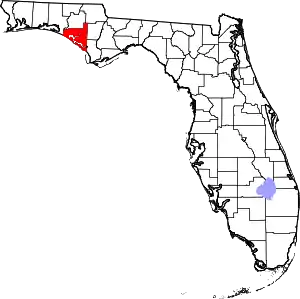 | |
| CDPs | ||
| Unincorporated communities | ||
| ||
| Authority control |
|---|