Parks and open spaces in the London Borough of Havering
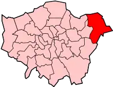
The London Borough of Havering is a London borough in northeast London, England. Part of Outer London, much of its area is protected from development by the Metropolitan Green Belt and more than half the borough is now parkland. Its parks and open spaces range from the large urban park to village greens and there are more than a hundred of them in total, mostly in the care of Havering London Borough Council (which are patrolled by Havering Parks Constabulary), but some by other organisations. Part of the extensive community forest known as Thames Chase is also within the borough and a large new regional parkland is currently under development, called Wildspace. There are 93 Sites of Importance for Nature Conservation in Havering.[1] Other parks and open spaces are:
| Park or open space | Green Flag | Co-ordinates |
|---|---|---|
| Bedfords Park | 51.606°N 0.192°E | |
| Central Park | 51.607°N 0.228°E | |
| Cottons Park | 51.575°N 0.172°E | |
| Harold Wood Park | 51.587°N 0.236°E | |
| Harrow Lodge Park | 51.557°N 0.202°E | |
| Havering Country Park | 51.614°N 0.170°E | |
| Hornchurch Country Park | 51.539°N 0.208°E | |
| Hylands Park | 51.571°N 0.201°E | |
| King Georges Playing Fields (also known as Mawney Park) | 51.585°N 0.165°E | |
Ingrebourne Valley Greenway:
|
||
| Langtons Gardens | 51.565°N 0.217°E | |
| Lawns Park | 51.596°N 0.168°E | |
| Lodge Farm Park | 51.582°N 0.192°E | |
| Pyrgo Park | 51.619°N 0.199°E | |
| Raphael Park | 51.589°N 0.190°E | |
| Rise Park | 51.597°N 0.185°E | |
| Tylers Common (also known as Upminster Common) | 51.592°N 0.259°E | |
| Upminster Park | 51.554°N 0.246°E | |
| Windmill Field | 51.559°N 0.245°E | |
| Wildspace | 51.502°N 0.195°E |
References
- "Sites of Importance for Nature Conservation in Havering" (PDF). London Borough of Havering. Archived from the original (PDF) on 2013-10-22. Retrieved 2013-10-18.
External links
- Havering London Borough Council: Parks and Open Spaces A - G
- Havering London Borough Council: Parks and Open Spaces H - Q
- Havering London Borough Council: Parks and Open Spaces R - Z