Peppermint Grove, Western Australia
Peppermint Grove is an affluent western suburb of Perth, Western Australia on the north bank of the Swan River at Freshwater Bay. Its local government area, the smallest in the country, is the Shire of Peppermint Grove. The suburb was named after its trademark Swan River peppermint trees (Agonis flexuosa) lining many streets. The suburb has long been associated with Western Australia's wealthiest and oldest families. Their prosperity is reflected in the many historical houses in the area, such as The Cliffe and the Federation Queen Anne style St Just.[2] Colin Barnett, a former Premier of Western Australia, dubbed the suburb "Monaco of WA" due to its small size and concentration of wealth.[3]
| Peppermint Grove Perth, Western Australia | |||||||||||||||
|---|---|---|---|---|---|---|---|---|---|---|---|---|---|---|---|
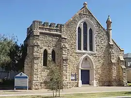 Front of St Columba's Presbyterian Church, Peppermint Grove | |||||||||||||||
 Peppermint Grove | |||||||||||||||
| Coordinates | 32°00′00″S 115°46′00″E | ||||||||||||||
| Population | 1,636 (2016 census)[1] | ||||||||||||||
| • Density | 1,490/km2 (3,850/sq mi) | ||||||||||||||
| Established | 1830s | ||||||||||||||
| Postcode(s) | 6011 | ||||||||||||||
| Area | 1.1 km2 (0.4 sq mi) | ||||||||||||||
| Location | 12 km (7 mi) SW of Perth CBD | ||||||||||||||
| LGA(s) | Shire of Peppermint Grove | ||||||||||||||
| State electorate(s) | Cottesloe | ||||||||||||||
| Federal Division(s) | Curtin | ||||||||||||||
| |||||||||||||||
History
At the time of European settlement and for some years after, the area was thickly wooded with tuart, jarrah, red gum, banksia as well as the peppermint trees which gave the suburb its name.
In 1830, John Butler, an innkeeper, was given a grant of 250 acres (1 km²) on Freshwater Bay, after unsuccessfully attempting to secure land at Claremont. From this location, he operated "The Bush Inn", a stone house he had built and rigged out with native mahogany, commonly known as jarrah. After a series of arguments with the colonial authorities of the day, Butler left for Sydney in October 1835, but did not dispose of the property.
After the death of Butler's wife, Ann, in 1886, a syndicate of businessmen, including Alexander Forrest and George Leake, persuaded Butler's children to sell the land.[4] In 1891, it was subdivided and lots were sold for £7 to £12 each. Two of the earliest residents were Edward Vivien Harvey Keane, Lord Mayor of Perth, and John Forrest, Premier of Western Australia. Just four years later, residents got a road board, later to become the Peppermint Grove Shire Council – to this day, the smallest in Australia at just 1.1 km².
Geography
Peppermint Grove is situated between Stirling Highway on the west and the Swan River at Freshwater Bay to the east. It spans six blocks, with its main streets named after the first post-subdivision residents of the suburb – McNeil, Forrest, Leake, Irvine, Keane, Johnston and Venn.
At the 2016 Australian census, Peppermint Grove had a high-income, mostly British Isles-derived population of 1,636 people living in 613 dwellings. 58% of the residents were female. The ABS noted that 64% of the suburb's workforce were professionals or managers (five percentage points less than the 2011 Census).[5]


Facilities
Cottesloe Primary School (est. 1896) and Presbyterian Ladies' College are located within the suburb, as are the shire council office and the Grove Library on Stirling Highway, a small shopping centre opposite Cottesloe's Napoleon Street shopping area, and reserves along the riverfront, most notably Manners Hill Park and Keanes Point Reserve, which offer recreational facilities and jetties.
The Grove Library
The Grove Library is funded by the Town of Cottesloe, the Shire of Peppermint Grove and the Town of Mosman Park. It houses the digital Grove Community History Library, which focuses on the people, places and events that have shaped the suburbs of Cottesloe, , Peppermint Grove and Mosman Park. It was established in 2006 as a conventional paper-based community collection but became digital in 2011.[6] Much of the collection is available online.
Churches
There are two churches in Peppermint Grove: St Columba's Presbyterian Church, a Presbyterian church located at the corner of Venn and Keane Streets; and St Mary Star of the Sea, a Roman Catholic church located on Stirling Highway at McNeil Street.[7]
Transport
The suburb is serviced by Fremantle to Perth bus services[8][9] and the CircleRoute bus route[10] along Stirling Highway, and by Cottesloe and Mosman Park railway stations on the Fremantle line. All services are operated by the Public Transport Authority.[11]
Politics
From 1901 to 1968 and from 1974 to 1980 Peppermint Grove was part of the federal Fremantle electorate, since 1934 a notional Labor seat. Its most prominent member was wartime Prime Minister John Curtin, a Cottesloe resident.[12]
Since 1980 it has been part of the federal division of Curtin. Curtin is regarded as a safe seat for the centre right Liberal Party, which has held the seat continually since its inception, with the exception of a period from 1996 to 1998 when former Liberal member Allan Rocher held the seat as an independent. The current member is Celia Hammond. In the parliament of Western Australia, its Legislative Assembly electoral district is Cottesloe, held by David Honey, also of the Liberal Party.[13]
Prominent residents
- Sir Charles Gairdner, Governor of Western Australia and Tasmania
- Members of the Burt family, such as Hon. Sir Francis Burt, former Governor and Chief Justice of Western Australia
- Members of the Lefroy family
- Members of the Lee-Steere family
- Members of the Forrest family, including Alexander Forrest
- Members of the Bunnings family
- Members of the Mahony family
- Bessie Rischbieth
- David Malcolm, former Lieutenant-Governor and Chief Justice of Western Australia
- David McComb, lead singer of The Triffids
- Richard Goyder, CEO of Wesfarmers
References
- Australian Bureau of Statistics (27 June 2017). "Peppermint Grove (State Suburb)". 2016 Census QuickStats. Retrieved 28 May 2020.

- "Proposed Entry to Heritage List, Attachment 3" (PDF). Shire of Peppermint Grove. Retrieved 28 May 2020.
- Thomas, Beatrice (17 March 2010). "Peppermint Grove resists Barnett lure". The West Australian. Perth, WA. Retrieved 28 May 2020.
- Bolton, Geoffrey; Gregory, Jenny (1999). Claremont – A History. Perth: University of WA Press. pp. 1–10. ISBN 1-876268-38-7.
- Australian Bureau of Statistics (25 October 2007). "Community Profile Series : Peppermint Grove (State Suburb)". 2006 Census of Population and Housing. Retrieved 30 December 2007.
- The Grove Community History Collection Development Policy, 2011
- "Peppermint Grove: Churches". Archived from the original on 23 March 2016. Retrieved 28 February 2014.
- "Bus Timetable 31" (PDF). Perth, WA: Transperth. 2 February 2020. Retrieved 28 May 2020.
- "Bus Timetable 32" (PDF). Perth, WA: Transperth. 21 July 2019. Retrieved 28 May 2020.
- "CircleRoute timetable" (PDF). Perth, WA: Transperth. February 2020. Retrieved 28 May 2020.
- "Fremantle Line" (PDF). Perth, WA: Transperth. 21 July 2019. Retrieved 28 May 2020.
- "John Curtin – Member for Fremantle". John Curtin Prime Ministerial Library. Curtin University. Retrieved 29 May 2020.
- "Hon. Colin James Barnett MLA". Member list. Perth, WA: Parliament of Western Australia. 2017. Retrieved 1 March 2017.