Picnic Point, New South Wales
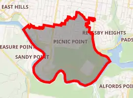
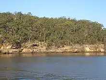
Picnic Point, a suburb of local government area City of Canterbury-Bankstown, is 23 kilometres south-west of the Sydney central business district, in the state of New South Wales, Australia. It is a part of South-western Sydney region . Picnic Point is a residential suburb on the northern bank of the Georges River. Located within Picnic Point is Yeramba Lagoon which is the largest tract of National Park within the Canterbury - Bankstown Council, it is home to numerous species of native fauna and flora.
| Picnic Point Sydney, New South Wales | |||||||||||||||
|---|---|---|---|---|---|---|---|---|---|---|---|---|---|---|---|
| |||||||||||||||
| Postcode(s) | 2213 | ||||||||||||||
| Location | 23 km (14 mi) south-west of Sydney CBD | ||||||||||||||
| LGA(s) | City of Canterbury-Bankstown | ||||||||||||||
| State electorate(s) | East Hills | ||||||||||||||
| Federal Division(s) | Banks | ||||||||||||||
| |||||||||||||||
History
Picnic Point was the name given to the geographical feature on the Georges River. The suburb was originally part of East Hills, which stretched south from Bankstown to the river and east to The River Road.[1]
During World War II, Picnic Point National Park was the location of a remote receiving station and operations bunker that was owned and operated by the RAAF.[2] This facility was used in conjunction with two other facilities, one of them located in Bankstown, the Bankstown Bunker, which was RAAF headquarters at the time and the other in Bass Hill which was a transmitting station in Johnston Road. The location of the remote receiving station in Picnic Point is now located under the Transgrid South Sydney electricity sub station.[3][4]
| 🌍 |
Schools
- Picnic Point High School [5]
- Picnic Point Public School [6]
Sport and recreation
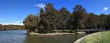
Picnic Point features a number of parks and reserves along the river, including the Georges River National Park. As the suburb’s name suggests, the area is popular with picnickers. The boat ramps provide access to the river for boating and watersports such as waterskiing and wakeboarding.
References
- The Book of Sydney Suburbs, Compiled by Frances Pollon, Angus & Robertson Publishers, 1990, Published in Australia ISBN 0-207-14495-8
- Bankstown Remote Receiving Building, during WW2
- see map - File:Bankstown01.jpg
- W/T. Transmit. Stn. of Bankstown, N.S.W., National Archives of Australia, archived from the original on 23 June 2009
- Picnic Point High School
- Picnic Point Public School
| Wikimedia Commons has media related to Picnic Point, New South Wales. |