Lansdowne, New South Wales
Lansdowne is a suburb in south-western Sydney, in the state of New South Wales, Australia. Lansdowne is located 27 kilometres west of the Sydney central business district, in the local government area of the City of Canterbury-Bankstown and is part of the South-western Sydney region.
| Lansdowne Sydney, New South Wales | |||||||||||||||
|---|---|---|---|---|---|---|---|---|---|---|---|---|---|---|---|
 | |||||||||||||||
 Boundaries of Lansdowne | |||||||||||||||
| Population | 17 (2016 census)[1] | ||||||||||||||
| Postcode(s) | 2163 | ||||||||||||||
| Location | 27 km (17 mi) west of Sydney CBD | ||||||||||||||
| LGA(s) | City of Canterbury-Bankstown | ||||||||||||||
| State electorate(s) | Bankstown | ||||||||||||||
| Federal Division(s) | Blaxland | ||||||||||||||
| |||||||||||||||
| 🌍 |
History
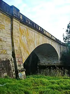
Lansdowne took its name from the Lansdowne Bridge, which was named by Governor Richard Bourke to honour Henry Petty-Fitzmaurice, 3rd Marquess of Lansdowne (1780-1863), a Whig politician.
The Lansdowne Bridge was built in 1834-35 from stone quarried on the banks of the Georges River. It replaced a hardwood bridge called Bowler's Bridge because it led to Bowler's Inn. The Lansdowne Bridge was one of the finest works by Scottish stonemason David Lennox (1788-1873), who arrived in Sydney in 1832 and was made Superintendent of Bridges with the task of replacing hardwood bridges that were frequently swept away in floods.
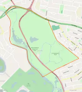
In 1962 the World Scout Jamboree was held at Lansdowne and the site, now Mirambeena Regional Park, was reserved for a future recreation area. Money for the project was supplied by federal and state governments and by Bankstown council. Today the park is a people's playground, with a Lake Gillawarna, and ponds full of wildlife, native walks and a pedestrian/cycle way. The picnic area has barbecues and all kinds of play equipment for children. This
Note that this suburb's name has occasionally in the past appeared on maps with a spelling of 'Landsdowne'.[2]
Transport
Lansdowne Bridge is a sandstone bridge built by David Lennox that (from 1957) carries northbound-only traffic of the Hume Highway over Prospect Creek which opened in 1836. Henry Lawson Drive runs along the western border of Lansvale, through Mirambeena Regional Park.
The Meccano Set is a notable set of traffic lights at the intersection of the Hume Highway, Henry Lawson Drive and Woodville Road.[3][4]
Parks
- Lansdowne Park features a road cycling circuit.
- Mirambeena Regional Park sits beside Prospect Creek
References
- Australian Bureau of Statistics (27 June 2017). "Lansdowne (State Suburb)". 2016 Census QuickStats. Retrieved 12 April 2018.

- The Book of Sydney Suburbs, Compiled by Frances Pollen, Angus & Robertson Publishers, 1990, Published in Australia ISBN 0-207-14495-8
- "Consultation on the future of the Meccano Set". Roads & Maritime Services. Government of New South Wales. Archived from the original on 20 October 2016.
- Georgakopoulos, Chris (9 June 2015). "Meccano set future on hold". Daily Telegraph. Australia. Retrieved 11 January 2017.