Plainfield (CDP), Vermont
Plainfield is a census-designated place (CDP) comprising the main village of the town of Plainfield, Washington County, Vermont, United States. The population of the CDP was 401 at the 2010 census.[2]
Plainfield, Vermont | |
|---|---|
_highlighted.svg.png.webp) Location in Washington County and the state of Vermont | |
| Coordinates: 44°16′39″N 72°25′28″W | |
| Country | United States |
| State | Vermont |
| County | Washington |
| Area | |
| • Total | 0.23 sq mi (0.60 km2) |
| • Land | 0.23 sq mi (0.59 km2) |
| • Water | 0.004 sq mi (0.01 km2) |
| Elevation | 755.2 ft (230.2 m) |
| Population (2010) | |
| • Total | 401 |
| • Density | 1,700/sq mi (670/km2) |
| Time zone | UTC-5 (Eastern (EST)) |
| • Summer (DST) | UTC-4 (EDT) |
| ZIP code | 05667 |
| Area code(s) | 802 |
| FIPS code | 50-55750[1] |
Geography
According to the United States Census Bureau, the Plainfield CDP has a total area of 0.23 square miles (0.60 km2), of which 0.23 square miles (0.59 km2) is land and 0.004 square miles (0.01 km2), or 2.18%, is water.[3] The village is located in the northern corner of the town of Plainfield along U.S. Route 2, 10 miles (16 km) east of Montpelier, the state capital, and 28 miles (45 km) west of St. Johnsbury. Goddard College is located just to the west of the CDP.
Plainfield is located on the Winooski River.
References
- "U.S. Census website". United States Census Bureau. Retrieved 2008-01-31.
- "Profile of General Population and Housing Characteristics: 2010 Demographic Profile Data (DP-1): Plainfield CDP, Vermont". United States Census Bureau. Retrieved September 20, 2012.
- "Geographic Identifiers: 2010 Demographic Profile Data (G001): Plainfield CDP, Vermont". United States Census Bureau. Retrieved September 20, 2012.
Municipalities and communities of Washington County, Vermont, United States | ||
|---|---|---|
| Cities | 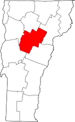 Map of Vermont highlighting Washington County | |
| Towns | ||
| Villages | ||
| CDPs | ||
| Other communities | ||
| ||
This article is issued from Wikipedia. The text is licensed under Creative Commons - Attribution - Sharealike. Additional terms may apply for the media files.