Polblue
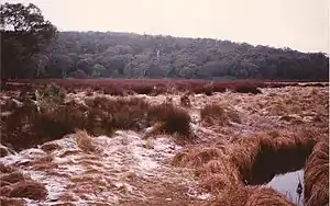
Polblue is a mountain on the Barrington Tops plateau, located in the Mid-Coast Council within New South Wales, Australia.
| Polblue | |
|---|---|
 Polblue and Polblue Swamp | |
| Highest point | |
| Elevation | 1,575 m (5,167 ft) |
| Coordinates | 31°58′S 151°27′E [1] |
| Geography | |
| Location | Barrington Tops National Park, New South Wales, Australia |
| Country | Australia |
| Parent range | Mount Royal Range |
| Geology | |
| Age of rock | Eocene |
At 1,575 metres (5,167 ft) above sea level, Polblue is the second highest point in the area after Brumlow Top. The surrounding area is covered by sub alpine snow gum woodland and high altitude swamps. Nearby is a popular camping ground and bushwalking trails contained with the Barrington Tops National Park.[2]
References
- "Polblue". Geographical Names Register (GNR) of NSW. Geographical Names Board of New South Wales. Retrieved 11 May 2015.

- "Barrington Tops National Park, Mount Royal National Park, and Barrington Tops State Conservation Area Plan of Management" (PDF). National Parks & Wildlife Service. NSW Government. Retrieved 30 May 2012.
This article is issued from Wikipedia. The text is licensed under Creative Commons - Attribution - Sharealike. Additional terms may apply for the media files.