Portnablagh
Portnablagh (Irish: Port na Bláiche, meaning, depending on translation, either 'Port of the Flowers' or 'Harbour of the Buttermilk',[1] possibly from the rough seas in the area) is a small village in County Donegal, Ireland. Portnablagh (also written in English as Port-na-Blagh) is located on Donegal's North West coast, specifically the west side of Sheephaven Bay. It is on the N56 road.[2]
Portnablagh
Port na Bláiche | |
|---|---|
Town | |
.jpeg.webp) The harbour in Portnablagh | |
 Portnablagh Location in Ireland | |
| Coordinates: 55°10′41″N 7°55′57″W | |
| Country | Ireland |
| Province | Ulster |
| County | County Donegal |
| Time zone | UTC+0 (WET) |
| • Summer (DST) | UTC-1 (IST (WEST)) |
| Irish Grid Reference | C055307 |
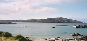
Portnablagh, along with neighbouring Dunfanaghy, is known for its beaches and harbour. It attracts tourists, mostly from Northern Ireland, every summer.
The small harbour is protected on 3 sides and has a relatively short slipway which is used by fishing and pleasure boat owners, particularly during summer months. It provides access for boat owners to beaches in Sheephaven Bay, many of which are only accessible on foot or by sea.
Faugher House
On the south-eastern edge of Portnablagh, between Ards Forest Park and Portnablagh itself, lie the ruins of Faugher House, also known as O'Boyle's Castle or Wray's Castle.[3][4] This small fortified house and its surrounding bawn were built during the Plantation of Ulster, and may have been built in stages throughout the seventeenth-century.[3] The original 'castle' or fortified house on this site was probably built for Toirdhealbhach Ruadh Ó Baoighill (sometimes anglicised as Turlough Roe O'Boyle or Tirlagh Roe O'Boyle) about 1611, shortly after he was granted land in the vicinity during the Plantation of Ulster.[3][5][6] Ó Baoighill and his family were originally from Kiltooris Castle, near both Portnoo and Narin in the south-west of County Donegal.[6][7] The surviving bawn on the site probably dates from this time, very early in the Plantation of Ulster.[3]
However, the surviving 'Plantation-era' fortified house (now ruined) may have been built in the second half of the seventeenth-century, possibly for the Wray family.[3][8][4]The building was probably abandoned by the mid-eighteenth-century.[8] The rather 'Scottish-style' ruin is beside 'the Middle Road', a sideroad leading to Breaghy Head, just off the N56, the main Letterkenny to Dunfanaghy road. The site is privately owned and is not open to the public.
References
- McKay, Patrick (1999). A Dictionary of Ulster Place-names. The Institute of Irish Studies, The Queen's University of Belfast. p. 121. ISBN 9780853897422.
- Untitled Page
- Brian Lacy, ed. (1983). Archaeological Survey of County Donegal. Lifford: Donegal County Council. pp. 367–369. ISBN 9780950840703.
- "Faugher House, Faugher (Ards), County Donegal". National Inventory of Architectural Heritage. Department of Culture, Heritage and the Gaeltacht.
- Alistair Rowan, The Buildings of Ireland: North West Ulster (popularly known as the Pevsner Guide to North West Ulster), p. 124. Yale, London, 2003 (originally published by Penguin, London, 1979).
- Gillespie, Fergus (2002) [1995]. Nolan, William; Ronayne, Liam; Dunlevy, Mairead (eds.). Gaelic Families of County Donegal, Donegal: History and Society. Dublin: Geography Publications. pp. 790–791.
- Tomás G. Ó Canann, 'A Historical Note on Baile Uí Chanann', in Seán Beattie (Editor), Donegal Annual Number 69, pp. 25-26. The County Donegal Historical Society, Ballyshannon, 2017.
- McLaren, Duncan; O'Meara, T. J. (2014). Cumming, Willie (ed.). An Introduction to the Architectural Heritage of County Donegal (PDF). National Inventory of Architectural Heritage (NIAH). Dublin: Department of Arts, Heritage and the Gaeltacht. pp. 20–21. ISBN 9781406426236.
Places in County Donegal | ||
|---|---|---|
| Towns | 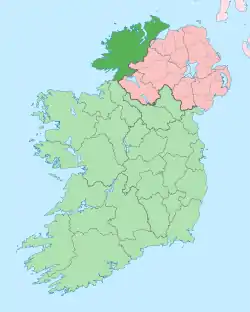 | |
| Villages |
| |
| Townlands | ||
| Islands | ||
| Other regions | ||
| ||