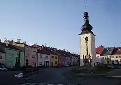
Potštát
Potštát (Czech pronunciation: [ˈpot.ʃtaːt]; German: Bodenstadt) is a town in Šumperk District in the Olomouc Region of the Czech Republic. It has about 1,200 inhabitants. The centre of the town is historically significant and is protected by law as urban monument zone.
Potštát | |
|---|---|
Town | |
 Town square | |
 Flag  Coat of arms | |
 Potštát Location in the Czech Republic | |
| Coordinates: 49°38′13″N 17°39′6″E | |
| Country | |
| Region | Olomouc |
| District | Šumperk |
| First mentioned | 1322 |
| Area | |
| • Total | 34.11 km2 (13.17 sq mi) |
| Elevation | 502 m (1,647 ft) |
| Population (2020-01-01[1]) | |
| • Total | 1,189 |
| • Density | 35/km2 (90/sq mi) |
| Time zone | UTC+1 (CET) |
| • Summer (DST) | UTC+2 (CEST) |
| Postal code | 753 62 |
| Website | www |
Administrative parts
Villages of Boškov, Kovářov, Kyžlířov and Lipná are administrative parts of Potštát.
History
From 1938 to 1945 it was one of the municipalities in Sudetenland.
References
- "Population of Municipalities – 1 January 2020". Czech Statistical Office. 2020-04-30.
| Wikimedia Commons has media related to Potštát. |
This article is issued from Wikipedia. The text is licensed under Creative Commons - Attribution - Sharealike. Additional terms may apply for the media files.