Horní Moštěnice
Horní Moštěnice (German: Ober Moschtienitz) is a municipality and village in Přerov District in the Olomouc Region of the Czech Republic. It has about 1,700 inhabitants.
Horní Moštěnice | |
|---|---|
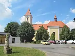 Church of the Assumption of the Virgin Mary | |
 Flag  Coat of arms | |
 Horní Moštěnice Location in the Czech Republic | |
| Coordinates: 49°24′44″N 17°27′32″E | |
| Country | |
| Region | Olomouc |
| District | Přerov |
| First mentioned | 1131 |
| Area | |
| • Total | 9.81 km2 (3.79 sq mi) |
| Elevation | 216 m (709 ft) |
| Population (2020-01-01[1]) | |
| • Total | 1,697 |
| • Density | 170/km2 (450/sq mi) |
| Time zone | UTC+1 (CET) |
| • Summer (DST) | UTC+2 (CEST) |
| Postal code | 751 17 |
| Website | www |
It lies 5 km (3.1 mi) south of the town of Přerov, on the road between Přerov and Otrokovice.
Etymology
The name of Horní Moštěnice is from the time of Great Moravia, when there was an important way connecting Velehrad with Přerov and Olomouc, leading through hags and marshes, so the path had to be hardened by bundles of wicker called moština, giving later the name to the village.
The streamlet Moštěnka, which flows through the municipality, used to be called Stvola after a willow-trees species (stvola in Old Slavic).[2]
History
The first written references about village come from 1131. In 1551 Horní Moštěnice became a market town.[2]
Švédské šance
Švédské šance is an old fortification about 1 km (0.62 mi) above the village, which is connected with Moštěnice's chapel in the middle of the village and with a not exactly known place in Přerov by abandoned tunnels.
The name (English: Swedish Rampart) comes from Thirty Years' War. The bunker was built by Swedish soldiers as a Swedish barrier. They assaulted other villages from this place. The fortification was used in the World War II as well.[2]
On 18–19 June 1945, Slovak Germans from Dobšiná were passing through Přerov while being transported back to Slovakia. Here they were taken out of the train by Slovakian soldiers, taken outside the city to a hill Švédské šance, where they were forced to dig their own graves and all were shot (71 men, 120 women and 74 children). One ethnic Slovakian woman and her boy, Paul Molnar, were exempt from the killing, Molnar's father was shot.[3]
Sights
Stronghold Štulbach
The first reference about stronghold is from 1389. The village and stronghold used to stand about 1 km east of Moštěnice, nowadays there is just lonely place and old un-used mill called Štulbach. The name Štulbach was derived from streamlet's name Stvola. Whole name of village and stronghold was half Czech and half German "Stvolbach" which was common in these days. According to old information, the stronghold was built from stones on an area 32 m × 83 m (105 ft × 272 ft).
In the beginning of the 19th century there were still ruines of a stronghold on that place. But in 1805 the residuals of old Štulbach was destroyed by mill-man Otáhal. Stones were sold or used for his new mill. In 1862 you could see bridge spillings in the Moštěnka. Between 1920 and 1926 there was a regulation of the Moštěnka which destroyed the last pieces of stronghold.
Castle Moštěnice
The stronghold was still in good condition after the Czech-Hungarian wars in the second half of the 15th century. For unknown reasons, the stronghold disappeared in the second half of the 16th century. The last information we have about it was in 1565.
The mansion was probably moved to the neighbouring village Moštěnice. The stronghold did appear here in about 1550 and after Thirty Years' War was changed to a Baroque castle with decoration park. At the beginning of the 19th century, it was changed into a landscape garden.
In the 20th century, the castle went through many alterations. After the World War I there was established a school upstairs in the castle which was here till 1975. In 1928, the municipality bought the castle with part of castle area and the municipal office was installed here. Nowadays there is a municipal office, a police station, and a veterinary doctor.
Education
A primary school was established in 1970, teaching about 200 pupils in classes from the first to the ninth grade.
Mineral springs
In Horní Moštěnice there are three mineral springs. The best-known of them is bottled as Hanácká kyselka (Hanakian acidulous water).[2]
Paleontology
Sometimes prior to 1945 a fossil tooth of a megalosauroid theropod dinosaur was found in Švédské šance. It comes from the Late Jurassic sediments and it belonged to a middle sized theropod dinosaur about 5 meters long.[4][5]
References
- "Population of Municipalities – 1 January 2020". Czech Statistical Office. 30 April 2020.
- "Historie" (in Czech). Obec Horní Moštěnice. Retrieved 18 October 2020.
- Marie Špalková: Horní Moštěnice – kapitoly z dějin obce, Horní Moštěnice 2006; ISBN 80-86247-03-1, pp. 114–116
- https://dinosaurusblog.com/2015/08/16/druhohorni-plazi-v-cechach-vii/
- Madzia, D. (2014). The first non-avian theropod from the Czech Republic. Acta Palaeontologica Polonica. 59 (4): 855–862.
| Wikimedia Commons has media related to Horní Moštěnice. |
| Authority control |
|
|---|