Prospect Heights, Brooklyn
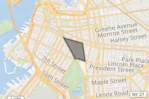
Prospect Heights is a neighborhood in the northwest of the New York City borough of Brooklyn. The traditional boundaries are Flatbush Avenue to the west, Atlantic Avenue to the north, Eastern Parkway – beginning at Grand Army Plaza – to the south, and Washington Avenue to the east. In the northern section of Prospect Heights are the Vanderbilt Rail Yards, built over as part of the Pacific Park (formerly Atlantic Yards) project. The Barclays Center, home to the NBA's Brooklyn Nets basketball team, is located in the northwestern corner of the neighborhood in Pacific Park at Flatbush and Atlantic Avenues.
Prospect Heights | |
|---|---|
 | |

Location in New York City | |
| Coordinates: 40°40′40″N 73°58′10″W | |
| Country | |
| State | |
| City | |
| Borough | |
| Community District | Brooklyn 8[1] |
| Population | |
| • Total | 67,645 |
| Race/Ethnicity | |
| • White | 47.2% |
| • Black | 30.1 |
| • Hispanic | 11.5 |
| • Asian | 6.6 |
| • Other | 4.6 |
| Time zone | UTC−5 (Eastern) |
| • Summer (DST) | UTC−4 (EDT) |
| ZIP Codes | 11217, 11238 |
| Area code | 718, 347, 929, and 917 |
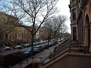
Compared to other Brooklyn neighborhoods, Prospect Heights is relatively small and is notable for its cultural diversity as well as its tree-lined streets. Prospect Heights has seen rapid demographic changes over the 2000s, and its shifts are exemplified by a mixture of older buildings under reconstruction, rows of classic 1890s brownstones, and newly built luxury condominiums. The neighborhood is served by the New York Police Department's 77th Precinct.[4]
Boundaries and land use

Along the southern boundary, Eastern Parkway, from Grand Army Plaza to Washington Avenue is reminiscent of Fifth Avenue's "Museum Mile" in Manhattan. Immense, opulent buildings line the north side of the parkway, and the south side features the Brooklyn Public Library, Mount Prospect Park (not to be confused with Prospect Park), the Brooklyn Botanic Garden and the recently renovated Brooklyn Museum. To Prospect Heights' north lies Fort Greene, to its south Prospect Park, to its west Park Slope, and to its east Crown Heights.
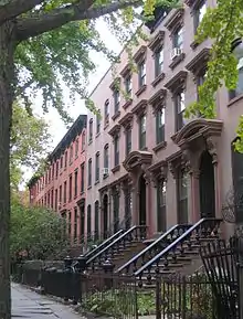
The interior portion of the neighborhood consists mostly of brownstone-style residential rowhouse buildings, some built as early as 1890, although some blocks, such as Lincoln and St. Johns Place between Underhill and Washington Avenues, include larger multi-unit apartment buildings. A number of new condominium complexes are under construction in many parts of the neighborhood. Defunct bakeries and factory spaces line Pacific Street from Vanderbilt Avenue to Carlton Avenue, and some have recently been renovated and converted into lofts; still others have recently been purchased by developer Bruce Ratner in anticipation of his Pacific Park project. Recently, a number of these have begun to be demolished. Ratner's company Forest City Ratner has planned a controversial development on top of the neighborhood, the plans for which would include a basketball arena and luxury housing. An upscale, glass high-rise residential building designed by the architect Richard Meier and located off of Grand Army Plaza was completed in 2008.
As demand for housing within Prospect Heights increased, some residents of Crown Heights came to consider Franklin Avenue the western border with Prospect Heights rather than Washington Avenue.[5] However, most residents continue to consider Washington Avenue the border,[6] and Washington Avenue remains the eastern border of Prospect Heights as recognized by major New York City media such as The New York Times, The New York Post, and The Wall Street Journal.[7]
The name "Prospect Heights" can be traced as far back as 1889 to a letter to the editor published in the Brooklyn Eagle, although at that time it was one of several potential names for the neighborhood that has since come to be known as Park Slope. The letter began by noting that it was "amusing to see the attempts made to fix upon a name for the rapidly growing part of Brooklyn near Prospect Park, bounded by Flatbush, Fifth and Ninth avenues, Some call it Park Slope, some Park Hill Side, some Prospect Heights and others Prospect Hill..."[8] Additionally, Prospect Heights once shared the name "Gowanus Heights" with Prospect Park, Greenwood and Bay Ridge.[9]
Controversy

In the late 2000s and early 2010s, the neighborhood experienced controversy over a development project by developer Bruce Ratner, initially designed by the architect Frank Gehry, for the portions of Prospect Heights and Fort Greene known as Pacific Park (formerly Atlantic Yards).[10] This included the construction of the Barclays Center, an arena to serve as a new home for the Brooklyn Nets basketball team, as well as housing and commercial space in a cluster of high-rise buildings much taller than the borough's existing low-rise architecture. A number of community groups opposed the project, claiming abuse of the principles of eminent domain, among other concerns. Supporters of the project believed in its potential for reinvigorating an unattractive space.
Architecture
The area has many Italianate and Neo-Grec rowhouses, and much of the neighborhood has been designated a New York City historic district. The Prospect Heights Historic District covers an area roughly bounded by Flatbush Avenue, Sterling Place, Washington Avenue, and St. Marks Avenue, though a section of the historic district extends as far north as Pacific Street.[11] It was listed on the National Register of Historic Places in 1983.[12] The district was designated by the city Landmarks Preservation Commission on June 23, 2009, and approved by the New York City Council on September 17, 2009. It is the fifth largest historic district in New York City.
The Co-Cathedral of St. Joseph of the Roman Catholic Diocese of Brooklyn, built in 1912 in Spanish Colonial style, is located at 856 Pacific Street between Vanderbilt and Underhill Avenues in Prospect Heights.
The neighborhood is also notable for its unusual street grid. The original street plan was based upon Lenape Indian paths and the boundaries of Dutch farms. As part of the Commissioners' Plan of 1839, this was redrawn to better match the rest of Brooklyn,[13] resulting in several buildings that are oddly-shaped or face the street at an angle.[14]
Demographics

Based on data from the 2010 United States Census, the population of Prospect Heights was 19,849, an increase of 194 (1.0%) from the 19,655 counted in 2000. Covering an area of 237.30 acres (96.03 ha), the neighborhood had a population density of 83.6 inhabitants per acre (53,500/sq mi; 20,700/km2).[3]
The racial makeup of the neighborhood was 47.2% (9,359) White, 30.1% (5,979) African American, 0.2% (34) Native American, 6.6% (1,316) Asian, 0.1% (12) Pacific Islander, 0.5% (106) from other races, and 3.9% (768) from two or more races. Hispanic or Latino of any race were 11.5% (2,275) of the population.[2]
The entirety of Community District 8, which covers Crown Heights North and Prospect Heights, had 97,130 inhabitants as of NYC Health's 2018 Community Health Profile, with an average life expectancy of 79.2 years.[15]:2, 20 This is lower than the median life expectancy of 81.2 for all New York City neighborhoods.[16]:53 (PDF p. 84)[17] Most inhabitants are middle-aged adults and youth: 20% are between the ages of 0–17, 37% between 25–44, and 22% between 45–64. The ratio of college-aged and elderly residents was lower, at 9% and 12% respectively.[15]:2
As of 2016, the median household income in Community District 8 was $60,107.[18] In 2018, an estimated 21% of Community District 8 residents lived in poverty, compared to 21% in all of Brooklyn and 20% in all of New York City. One in eleven residents (9%) were unemployed, compared to 9% in the rest of both Brooklyn and New York City. Rent burden, or the percentage of residents who have difficulty paying their rent, is 50% in Community District 8, lower than the citywide and boroughwide rates of 52% and 51% respectively. Based on this calculation, as of 2018, Community District 8 is considered to be gentrifying.[15]:7
Culture
A diverse ethnic neighborhood in the 1910s through the 1960s, combining Italian, Irish, Jewish, German, Greek and Yankee residents, Prospect Heights is currently well known for its mixed black and white culture. Every year the West Indian Day Parade, the largest annual parade in New York City, follows Eastern Parkway, beginning in Crown Heights and ending at Grand Army Plaza in Prospect Heights. During the last thirty years, the neighborhood has seen an influx of new residents, increasingly young and white,[19] perhaps due to real estate prices slightly lower than neighboring Park Slope. A thriving commercial zone has emerged along Vanderbilt Avenue and Washington Avenue, which since 2000 has seen a surge in new bars, restaurants, and specialty shops, including New York's first steampunk bar, boutique wine shops, a restaurant opened by Michelin-starred chef Saul Bolton, and stores emphasizing gourmet/artisanal mayonnaise and ice cream.
Police and crime
Prospect Heights is patrolled by the 77th Precinct of the NYPD, located at 127 Utica Avenue.[20] The 77th Precinct ranked 42nd safest out of 69 patrol areas for per-capita crime in 2010.[21] As of 2018, with a non-fatal assault rate of 85 per 100,000 people in Community District 8, its rate of violent crimes per capita is greater than that of the city as a whole. The incarceration rates of 872 per 100,000 people Community District 8 is greater than that of the city as a whole.[15]:8
The 77th Precinct has a lower crime rate than in the 1990s, with crimes across all categories having decreased by 85.7% between 1990 and 2018. The precinct reported 2 murders, 32 rapes, 180 robberies, 297 felony assaults, 158 burglaries, 397 grand larcenies, and 72 grand larcenies auto in 2018.[22]
Fire safety
The New York City Fire Department (FDNY) operates two fire stations in Prospect Heights:[23]
Health
As of 2018, preterm births and births to teenage mothers in Community District 8 are more common than in other places citywide. There were 92 preterm births per 1,000 live births in Community District 8 (compared to 87 per 1,000 citywide) and 24.6 births to teenage mothers per 1,000 live births in Community District 8 (compared to 19.3 per 1,000 citywide).[15]:11 Community District 8 has a relatively high population of residents who are uninsured, or who receive healthcare through Medicaid.[26] In 2018, this population of uninsured residents was estimated to be 12%, compared to the citywide rate of 12%.[15]:14
The concentration of fine particulate matter, the deadliest type of air pollutant, is 0.008 milligrams per cubic metre (8.0×10⁻⁹ oz/cu ft) in Community District 8, slightly higher than the citywide and boroughwide averages.[15]:9 Eighteen percent of Community District 8 residents are smokers, compared to the city average of 14% of residents being smokers.[15]:13 In Community District 8, 26% of residents are obese, 13% are diabetic, and 33% have high blood pressure—compared to the citywide averages of 24%, 11%, and 28% respectively.[15]:16 In addition, 19% of children are obese in Community District 8, compared to the citywide average of 20%.[15]:12
Eighty-four percent of Community District 8 residents eat some fruits and vegetables every day, which is slightly lower than the city's average of 87%. In 2018, 78% of Community District 8 residents described their health as "good," "very good," or "excellent," compared to than the city's average of 78%.[15]:13 For every supermarket, there are 25 bodegas in Community District 8.[15]:10
Post offices and ZIP Codes
Prospect Heights is covered by ZIP Codes 11217 and 11238.[27] The United States Postal Service operates two post offices nearby: the Times Plaza Annex Station at 594 Dean Street,[28] and the Adelphi Station at 950 Fulton Street.[29]
Education
Community District 8 generally has a similar ratio of college-educated residents to the rest of the city as of 2018. In Community District 8, 44% of residents age 25 and older have a college education or higher, while 16% have less than a high school education and 40% are high school graduates or have some college education. By contrast, 40% of Brooklynites and 38% of city residents have a college education or higher.[15]:6 The percentage of Community District 8 students excelling in reading and math has been increasing, with reading achievement rising from 31 percent in 2000 to 37 percent in 2011, and math achievement rising from 22 percent to 47 percent within the same time period.[30]
Community District 8's rate of elementary school student absenteeism is higher than the rest of New York City. The proportion of elementary school students who missed twenty or more days per school year was 28% in Community District 8, compared to the citywide average of 20% of students.[16]:24 (PDF p. 55)[15]:6 Additionally, 71% of high school students in Community District 8 graduate on time, compared to the citywide average of 75% of students.[15]:6
Schools
Prospect Heights contains the following public schools:
German School Brooklyn, a German international school, is on the fifth floor of the Union Temple of Brooklyn.[33]
Library
The Brooklyn Public Library's Brooklyn Central Library is located at Grand Army Plaza, on the southern side of Prospect Heights.[34]
Transportation
Five New York City Bus lines serve Prospect Heights:[35]
- B41: to Bergen Beach/Mill Basin or Downtown Brooklyn via Flatbush Avenue[36]
- B45: to Crown Heights or Downtown Brooklyn via Atlantic and Washington Avenues[37]
- B65: to Crown Heights or Downtown Brooklyn via Bergen and Dean Streets[38]
- B67: to Kensington or Brooklyn Navy Yard via Flatbush Avenue[39]
- B69: to Kensington or Dumbo via Vanderbilt Avenue[40]
Several New York City Subway stations are located in Prospect Heights. The IRT Eastern Parkway Line (2 and 3 trains) has stations at Bergen Street, Grand Army Plaza, and Brooklyn Museum, while the BMT Brighton Line (B and Q trains) has a station at Seventh Avenue.[41]
Notable residents
- Barbara Barrie, actress
- Matt Berninger, musician
- Matt Bomer, actor
- Clara Bow, actress[42]
- Foxy Brown, rapper
- Aaron Copland, Clara Bow and Howard Cosell went to the old Public School 9 at the corner of Sterling and Vanderbilt.
- Bobby Fischer Chess grandmaster lived on Lincoln Place near Underhill
- MC Frontalot, founder, Nerdcore
- Keith Gessen, co-editor-in-chief of n+1, novelist
- Montego Glover, actress
- Ingrid Michaelson, singer, songwriter
- Isa Chandra Moskowitz vegan chef, cookbook writer, and host of "The Post Punk Kitchen", which is filmed in Prospect Heights
- Michael Moss, Pulitzer Prize winning author
- Eddie Ocampo, drummer
- Joe Pepitone NY Yankees player lived on St. Mark’s Avenue between Vanderbilt and Washington
- Joan Rivers, comedian
- Mark Rudd, leader in the 1960s' Weather Underground, and Columbia University's 1968 protests. When he lived "underground" in the early 1970s, it was in one of the large apartment buildings on Plaza Street.
- Emanuel Weiss, member of the Mafia hit squad Murder, Inc. during the 1930s
- Tobias Wilner, musician
References
- "NYC Planning | Community Profiles". communityprofiles.planning.nyc.gov. New York City Department of City Planning. Retrieved March 18, 2019.
- Table PL-P3A NTA: Total Population by Mutually Exclusive Race and Hispanic Origin - New York City Neighborhood Tabulation Areas*, 2010, Population Division - New York City Department of City Planning, March 29, 2011. Accessed June 14, 2016.
- Table PL-P5 NTA: Total Population and Persons Per Acre - New York City Neighborhood Tabulation Areas*, 2010, Population Division - New York City Department of City Planning, February 2012. Accessed June 16, 2016.
- "NYPD Precinct Finder". Nyc.gov. January 18, 2015. Retrieved January 18, 2015.
- Siwilop, Sana (September 19, 2004). "LIVING IN/Crown Heights; Casting an Eye Toward Brooklyn's 'Hidden Jewel'". The New York Times. ISSN 0362-4331. Retrieved August 19, 2009.
- "Crown Heights Borders and Boundaries – The Results" on nostrandpark.com
- See:
- Berck, Judith, "Prospect Heights" in Jackson, Kenneth T., ed. (2010). The Encyclopedia of New York City (2nd ed.). New Haven: Yale University Press. p. 1042. ISBN 978-0-300-11465-2. The Encyclopedia names Washington Avenue as the eastern border.
- Plambeck, Joseph (April 14, 2011). "Tucked Between Past and Future in Brooklyn". The New York Times. ISSN 0362-4331. Retrieved April 19, 2011.
- Dykstra, Katherine (October 15, 2009). "In the Heights; Prospect Heights could be the next Cobble Hill". The New York Post. Retrieved October 15, 2009.
- Mooney, Jake (June 16, 2010). "Living In-Crown Heights, Brooklyn". The New York Times. ISSN 0362-4331. Retrieved June 21, 2010.
- Avila, Joseph De (December 11, 2010). "Prospect Heights: Slope Appeal With Edge". Wall Street Journal. ISSN 0099-9660. Retrieved May 1, 2020.
- "Slope, Heights or Hill". Brooklyn Eagle. March 17, 1889. Archived from the original on September 30, 2007. Retrieved August 20, 2009.
- Higgins, Charles Michael (1916). Brooklyn and Gowanus in History: The Battle of Long Island, August 27, 1776. Brooklyn Eagle Press. p. 6. Retrieved December 20, 2011.
- "After 11 Years of Controversy, Atlantic Yards Becomes Pacific Park Brooklyn". nextcity.org. August 26, 2014. Retrieved April 20, 2020.
- phndc.org. "Prospect Heights Historic District". phndc.org. Archived from the original on February 11, 2012. Retrieved June 8, 2012.
- "National Register Information System". National Register of Historic Places. National Park Service. March 13, 2009.
- Keith, Stephanie (February 17, 2011). "Lost on the Old Grid: The History Behind Prospect Heights' Diagonal Buildings". Prospect Heights-Crown Heights-PLG, NY Patch. Retrieved September 22, 2017.
- Jackson, Josh (April 2007). "LOST Magazine - 323 Prospect Place". www.lostmag.com. Retrieved September 22, 2017.
- "Crown Heights and Prospect Heights (Including Crown Heights, Prospect Heights and Weeksville)" (PDF). nyc.gov. NYC Health. 2018. Retrieved March 2, 2019.
- "2016-2018 Community Health Assessment and Community Health Improvement Plan: Take Care New York 2020" (PDF). nyc.gov. New York City Department of Health and Mental Hygiene. 2016. Retrieved September 8, 2017.
- "New Yorkers are living longer, happier and healthier lives". New York Post. June 4, 2017. Retrieved March 1, 2019.
- "NYC-Brooklyn Community District 8--Crown Heights North & Prospect Heights PUMA, NY". Retrieved July 17, 2018.
- Solish, Scott (October 8, 2008). "Adding to the Mix in Brooklyn". The New York Times. ISSN 0362-4331. Retrieved April 20, 2020.
- "NYPD – 77th Precinct". www.nyc.gov. New York City Police Department. Retrieved October 3, 2016.
- "Prospect Heights & Crown Heights – DNAinfo.com Crime and Safety Report". www.dnainfo.com. Archived from the original on March 6, 2019. Retrieved October 6, 2016.
- "77th Precinct CompStat Report" (PDF). www.nyc.gov. New York City Police Department. Retrieved July 22, 2018.
- "FDNY Firehouse Listing – Location of Firehouses and companies". NYC Open Data; Socrata. New York City Fire Department. September 10, 2018. Retrieved March 14, 2019.
- "Engine Company 280/Ladder Company 132". FDNYtrucks.com. Retrieved March 2, 2019.
- "Engine Company 219/Ladder Company 105". FDNYtrucks.com. Retrieved March 2, 2019.
- New York City Health Provider Partnership Brooklyn Community Needs Assessment: Final Report, New York Academy of Medicine (October 3, 2014).
- "Flatbush, New York City-Brooklyn, New York Zip Code Boundary Map (NY)". United States Zip Code Boundary Map (USA). Retrieved March 27, 2019.
- "Location Details: Times Plaza Annex". USPS.com. Retrieved March 5, 2019.
- "Location Details: Adelphi". USPS.com. Retrieved March 5, 2019.
- "Crown Heights / Prospect Heights – BK 08" (PDF). Furman Center for Real Estate and Urban Policy. 2011. Retrieved October 5, 2016.
- "P.S. 009 Teunis G. Bergen". New York City Department of Education. Retrieved April 21, 2020.
- "I.S. 340". New York City Department of Education. Retrieved April 21, 2020.
- "Contact and Location". German School Brooklyn. Retrieved May 15, 2020.
The German School Brooklyn is located [...] on the 5th Floor of the Union Temple building on Eastern Parkway.
- "Central Library". Brooklyn Public Library. January 29, 2016. Retrieved February 21, 2019.
- "Brooklyn Bus Map" (PDF). Metropolitan Transportation Authority. October 2020. Retrieved December 1, 2020.
- MTA Regional Bus Operations. "B41 bus schedule" (PDF).
- MTA Regional Bus Operations. "B45 bus schedule" (PDF).
- MTA Regional Bus Operations. "B65 bus schedule" (PDF).
- MTA Regional Bus Operations. "B67 bus schedule" (PDF).
- MTA Regional Bus Operations. "B69 bus schedule" (PDF).
- "Subway Map" (PDF). Metropolitan Transportation Authority. October 21, 2019. Retrieved January 18, 2018.
- Stenn, David (1988). Clara Bow:Runnin' Wild. Doubleday. p. 322. ISBN 0-385-24125-9.
External links
 Media related to Prospect Heights, Brooklyn at Wikimedia Commons
