Crown Heights, Brooklyn
Crown Heights is a neighborhood in the central portion of the New York City borough of Brooklyn. Crown Heights is bounded by Washington Avenue to the west, Atlantic Avenue to the north, Ralph Avenue to the east, and Empire Boulevard/East New York Avenue to the south. It is about 1 mile (1.6 km) wide and 2 miles (3.2 km) long. Neighborhoods bordering Crown Heights include Prospect Heights to the west, Flatbush and Prospect Lefferts Gardens to the south, Brownsville to the east, and Bedford-Stuyvesant to the north.
Crown Heights | |
|---|---|
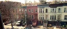 Typical Crown Heights row houses | |
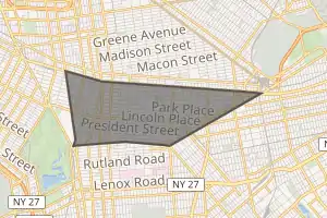
Location in New York City | |
| Coordinates: 40.673°N 73.946°W | |
| Country | |
| State | |
| City | |
| Borough | |
| Community District | Brooklyn 8,[1] Brooklyn 9[2] |
| Area | |
| • Total | 3.67 km2 (1.418 sq mi) |
| Population (2016)[3] | |
| • Total | 143,000 |
| • Density | 39,000/km2 (100,000/sq mi) |
| Ethnicity | |
| • Black | 74.7% |
| • White | 19.1% |
| • Hispanic | 4.2% |
| • Asian | 2% |
| Economics | |
| • Median income | $45,776 |
| Time zone | UTC−5 (Eastern) |
| • Summer (DST) | UTC−4 (EDT) |
| ZIP Codes | 11213, 11216, 11233, 11238, 11225 |
| Area code | 718, 347, 929, and 917 |
The main thoroughfare through this neighborhood is Eastern Parkway, a tree-lined boulevard designed by Frederick Law Olmsted extending 2 miles (3.2 kilometres) east–west. Originally, the area was known as Crow Hill. It was a succession of hills running east and west from Utica Avenue to Washington Avenue, and south to Empire Boulevard and East New York Avenue.[4] The name was changed when Crown Street was cut through in 1916.[5]
The northern half of Crown Heights is part of Brooklyn Community District 8 and is patrolled by the 77th Precinct of the New York City Police Department (NYPD).[1][6] The southern half is part of Brooklyn Community District 9 and is patrolled by the 71st Precinct of the NYPD.[2][7] Crown Heights's primary ZIP Codes are 11213, 11216, 11233, 11238, and 11225. Politically, it is represented by the New York City Council's 35th, 36th, and 41st Districts.
History
Early history
Although no known physical evidence remains in the Crown Heights vicinity, large portions of what is now called Long Island including present-day Brooklyn were occupied by the Lenape, (later renamed Delaware Indians by the European colonizers). The Lenape lived in communities of bark- or grass-covered wigwams, and in their larger settlements—typically located on high ground adjacent to fresh water, and occupied in the fall, winter, and spring—they fished, harvested shellfish, trapped animals, gathered wild fruits and vegetables, and cultivated corn, tobacco, beans, and other crops.
The first recorded contact between the indigenous people of the New York City region and Europeans was with the Italian explorer Giovanni da Verrazzano in 1524 in the service of France when he anchored at the approximate location where the Verrazano-Narrows Bridge touches down in Brooklyn today. There he was visited by a canoe party of Lenape. The next contact was in 1609 when the explorer Henry Hudson arrived in what is now New York Harbor aboard a Dutch East India Company ship, the Halve Maen (Half Moon) commissioned by the Dutch Republic.
European habitation in the New York City area began in earnest with the founding of a Dutch fur trading settlement, later called "Nieuw Amsterdam" (New Amsterdam), on the southern tip of Manhattan in 1614. By 1630, Dutch and English colonists started moving into the western end of Long Island. In 1637, Joris Jansen de Rapalje[8] purchased about 335 acres (1.36 km2) around Wallabout Bay and over the following two years, director Kieft of the Dutch West India Company purchased title to nearly all the land in what is now Kings County and Queens County from the indigenous inhabitants.
Finally, the areas around present-day Crown Heights saw its first European settlements starting in about 1661/1662 when several men each received, from Governor Peter Stuyvesant and the directors of the Dutch West India Company what was described as “a parcel of free (unoccupied) woodland there” on the condition that they situate their houses “within one of the other concentration, which would suit them best, but not to make a hamlet.”[9][10]
Early and mid-20th century
Crown Heights had begun as a fashionable residential neighborhood, a place for secondary homes in which Manhattan's growing bourgeois class could reside. The area benefited by having its rapid transit in a subway configuration, the IRT Eastern Parkway Line (2, 3, 4, and 5 trains), in contrast to many other Brooklyn neighborhoods, which had elevated lines. Conversion to a commuter town also included tearing down the 19th century Kings County Penitentiary at Carroll Street and Nostrand Avenue.[11]
Beginning in the early 1900s, many upper-class residences, including characteristic brownstone buildings, were erected along Eastern Parkway. Away from the parkway were a mixture of lower middle-class residences. This development peaked in the 1920s. Before World War II Crown Heights was among New York City's premier neighborhoods, with tree-lined streets, an array of cultural institutions and parks, and numerous fraternal, social and community organizations.
From the early 1920s through the 1960s, Crown Heights was an overwhelmingly white neighborhood and predominantly Jewish.[12] Population changes began in the 1920s with newcomers from Jamaica and the West Indies, as well as African Americans from the South. In 1950, the neighborhood was 89 percent white, with some 50 to 60 percent of the white population, or about 75,000 people, being Jewish, and a small, growing black population. By 1957, there were about 25,000 blacks in Crown Heights, making up about one-fourth of the population. Following the end of World War II, suburbanization began to rapidly affect Crown Heights and Brooklyn. Robert Moses expanded the borough’s access to Long Island through expressway construction, and by way of the G.I. Bill, many families moved east. Most of these opportunities were limited to whites. Levittown in Long Island, for example, forbid applications from black families. As the Jewish, Irish and Italian populations of Crown Heights moved out of the neighborhood, black people from the south and immigrants from the Caribbean continued to move there. The 1957 departure of the Brooklyn Dodgers and the destruction of Ebbets Field for public housing for its black population symbolically served as the end of the old white ethnic Crown Heights[13] and in the 1960s the neighborhood experienced mass white flight. The demographic change was astounding; in 1960 the neighborhood was 70% white, by 1970 it was 70% black. The one exception to this pattern was the Lubavitch Hasidic Jews.[12]
There were thirty-four large synagogues in the neighborhood, including the Bobov, Chovevei Torah, and 770 Eastern Parkway, home of the worldwide Lubavitch movement. There were also three prominent Yeshiva elementary schools in the neighborhood, Crown Heights Yeshiva on Crown Street, the Yeshiva of Eastern Parkway, and the Reines Talmud Torah.
Late 20th century
The 1960s and 1970s were a time of turbulent race relations in the area: With increasing poverty in the city, racial conflict plagued some of its neighborhoods, including Crown Heights, with its racially and culturally mixed populations. The neighborhood's relatively large population of Lubavitch Hasidim, at the request of their leader, the Lubavitcher Rebbe Menachem Mendel Schneerson stayed in the community after other whites left.
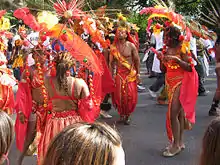
In 1964 the Labor Day Carnival celebrating Caribbean culture was moved to the neighborhood when its license to run in Harlem was revoked. It now attracts between one and three million people and is held on the first Monday in September.
During the Lyndon B. Johnson administration, Crown Heights was declared a primary poverty area due to a high unemployment rate, high juvenile and adult crime rate, poor nutrition due to lack of family income, relative absence of job skills and readiness, and a relatively high concentration of elderly residents. Violence broke out several times in the neighborhood during the late 20th century, including during the New York City blackout of 1977: More than 75 area stores were robbed, and thieves used cars to pull up roll-down curtains in front of stores.
In 1991, there was a three-day outbreak known as the Crown Heights Riot, which started between the neighborhood's West Indian/African American and Jewish communities. The riots began on August 19, 1991 after Gavin Cato, the son of two Guyanese immigrants, was struck and killed by a car in the motorcade of prominent Hasidic rabbi Menachem Mendel Schneerson. A mob began to attack a Jewish volunteer ambulance, which withdrew. Rumors circulated that the ambulance refused to treat Gavin Cato's injuries while removing members of Schneerson's motorcade instead. Yankel Rosenbaum, a visiting rabbinical student from Australia, was killed in the riot, while Jews and Blacks were assaulted, and there was property damage amid rock throwing in the ensuing riots. The riot unveiled long-simmering tensions between the neighborhood's Black and Jewish communities, which impacted the 1993 mayoral race and ultimately led to a successful outreach program between Black and Jewish leaders that somewhat helped improve race relations in the city.[14][15] Through the 1990s, crime, racial conflict, and violence decreased in the city and urban renewal and gentrification began to take effect including in Crown Heights.
Early 21st century
In the 2010s, Crown Heights experienced rapid gentrification.[16][17] In some areas the increasing rents have caused the displacement of long-time residents.[18][19][20] Not only did rents for each apartment increase drastically but building management firms such as BCB Realty, affiliated with companies that buy up buildings in the neighborhood, aimed to remove long-term residents by buying them out or pressuring them to move by "failing to adequately maintain apartments," according to a housing activist, with the aim of forcing out the rent-stabilized. Other tactics include relocating residents from their apartments claiming renovation and locking them out, as employed by another realtor in the neighborhood, ZT Realty.[21] In 2017, real estate developer Isaac Hager faced opposition from activists when he proposed building a 565-unit apartment complex in Crown Heights;[22] in April 2019, a judge issued a restraining order against the project.[23]
In the wake of the 2010 opening of Basil Pizza & Wine Bar, a series of upscale, kosher, foodie restaurants opened in Crown Heights, which The Jewish Week described as "an eating destination."[24]
In November 2013, a series of attacks on Jewish residents were suspected to be part of "knockout games". Media attention to knockout attacks increased following the incidents in Crown Heights.[25][26][27][28][29][30] In response to the violence, the Jewish community hosted an event for African-American teens, designed to promote greater understanding of Jews and their beliefs. The event, hosted by the Jewish Children's Museum, was coordinated by local Jewish organizations, public schools, and by the NYPD's 71st and 77th precincts.[31]
Demographics
Crown Heights is divided into two neighborhood tabulation areas, Crown Heights North and Crown Heights South, which collectively comprise the population of Crown Heights.[32]
Crown Heights has a majority West Indian and African American population according to the 2010 census. Reflecting the most varied population of Caribbean immigrants outside the West Indies, Crown Heights is known for its annual West Indian Carnival. The vivid ostentation goes along Eastern Parkway, from Utica Avenue to Grand Army Plaza. According to the West Indian-American Day Carnival Association, over 3.5 million people participate in the parade each year.[33] However, it is often the scene of gang violence.[34]
Crown Heights also contains a significant number of Hasidic Jews.[35] It is the location of the Worldwide Headquarters of the Chabad-Lubavitch Hasidic Jewish movement, at 770 Eastern Parkway. An Orthodox Jewish community which established itself in Crown Heights in the 1940s has continued to thrive around that location.
Crown Heights North
Based on data from the 2010 United States Census, the population of Crown Heights North was 103,169, a change of -293 (-0.3%) from the 103,462 counted in 2000. Covering an area of 1,185.56 acres (479.78 ha), the neighborhood had a population density of 87 inhabitants per acre (56,000/sq mi; 21,000/km2).[36]
The racial makeup of the neighborhood was 9.9% (10,237) White, 74% (76,358) African American, 0.2% (238) Native American, 1.9% (1,926) Asian, 0% (16) Pacific Islander, 0.4% (374) from other races, and 1.9% (1,969) from two or more races. Hispanic or Latino of any race were 11.7% (12,051) of the population.[37]
The entirety of Community District 8, which covers Crown Heights North, had 97,130 inhabitants as of NYC Health's 2018 Community Health Profile, with an average life expectancy of 79.2 years.[38]:2, 20 This is lower than the median life expectancy of 81.2 for all New York City neighborhoods.[39]:53 (PDF p. 84)[40] Most inhabitants are middle-aged adults and youth: 20% are between the ages of 0–17, 37% between 25–44, and 22% between 45–64. The ratio of college-aged and elderly residents was lower, at 9% and 12% respectively.[38]:2
As of 2016, the median household income in Community District 8 was $60,107.[41] In 2018, an estimated 21% of Crown Heights North residents lived in poverty, compared to 21% in all of Brooklyn and 20% in all of New York City. One in eleven residents (9%) were unemployed, compared to 9% in the rest of both Brooklyn and New York City. Rent burden, or the percentage of residents who have difficulty paying their rent, is 50% in Crown Heights North, lower than the citywide and boroughwide rates of 52% and 51% respectively. Based on this calculation, as of 2018, Crown Heights North is considered to be gentrifying.[38]:7
Crown Heights South
Based on data from the 2010 United States Census, the population of Crown Heights South was 39,670, a change of -2,700 (-6.8%) from the 42,370 counted in 2000. Covering an area of 366.94 acres (148.50 ha), the neighborhood had a population density of 108.1 inhabitants per acre (69,200/sq mi; 26,700/km2).[36]
The racial makeup of the neighborhood was 25.8% (10,221) White, 62.8% (24,921) African American, 0.2% (81) Native American, 0.7% (285) Asian, 0% (12) Pacific Islander, 0.3% (127) from other races, and 1.5% (601) from two or more races. Hispanic or Latino of any race were 8.6% (3,422) of the population.[37]
The entirety of Community District 9, which covers Crown Heights South, had 98,650 inhabitants as of NYC Health's 2018 Community Health Profile, with an average life expectancy of 81.2 years.[42]:2, 20 This is equal to the median life expectancy of all New York City neighborhoods.[39]:53 (PDF p. 84)[40] Most inhabitants are middle-aged adults and youth: 22% are between the ages of 0–17, 30% between 25–44, and 25% between 45–64. The ratio of college-aged and elderly residents was lower, at 9% and 14% respectively.[42]:2
As of 2016, the median household income in Community District 9 was $51,072.[43] In 2018, an estimated 22% of Crown Heights South residents lived in poverty, compared to 21% in all of Brooklyn and 20% in all of New York City. One in nine residents (11%) were unemployed, compared to 9% in the rest of both Brooklyn and New York City. Rent burden, or the percentage of residents who have difficulty paying their rent, is 55% in Crown Heights South, higher than the citywide and boroughwide rates of 52% and 51% respectively. Based on this calculation, as of 2018, Crown Heights South is considered to be gentrifying.[42]:7
Politics
The neighborhood is part of New York's 9th congressional district, represented by Democrat Yvette Clarke as of 2013.[44] It is also part of the 19th and 20th State Senate districts, represented by Democrats Roxanne Persaud and Zellnor Myrie,[45][46] and the 43rd and 57th State Assembly districts, represented respectively by Democrats Diana Richardson and Walter T. Mosley.[47][48] Crown Heights is located in New York's 35th and 36th City Council districts, represented respectively by Democrats Laurie Cumbo and Robert Cornegy.[49][50]
Crown Heights is served by Brooklyn Community Board 8 north of Eastern Parkway and Brooklyn Community Board 9 south of Eastern Parkway.
Police and crime
Crown Heights is patrolled by two precincts of the NYPD.[51] Crown Heights North is covered by the 77th Precinct, located at 127 Utica Avenue,[6] while Crown Heights South is patrolled by the 71st Precinct, located at 421 Empire Boulevard.[7]
The 77th Precinct ranked 42nd safest out of 69 patrol areas for per-capita crime in 2010,[52] while the 71st Precinct ranked 46th safest.[53] As of 2018, with a non-fatal assault rate of 85 per 100,000 people in Crown Heights North and 73 per 100,000 people in Crown Heights South, both areas' rates of violent crimes per capita are greater than that of the city as a whole. The incarceration rates of 872 per 100,000 people in Crown Heights North and 598 per 100,000 people in Crown Heights South are both greater than that of the city as a whole.[38]:8[42]:8
The 77th Precinct has a lower crime rate than in the 1990s, with crimes across all categories having decreased by 85.7% between 1990 and 2018. The precinct reported 2 murders, 32 rapes, 180 robberies, 297 felony assaults, 158 burglaries, 397 grand larcenies, and 72 grand larcenies auto in 2018.[54] The 71st Precinct also has a lower crime rate than in the 1990s, with crimes across all categories having decreased by 82.7% between 1990 and 2018. The precinct reported 8 murders, 26 rapes, 166 robberies, 349 felony assaults, 143 burglaries, 464 grand larcenies, and 68 grand larcenies auto in 2018. [55]
Fire safety
The New York City Fire Department (FDNY) operates four fire stations in Crown Heights:[56]
Health
As of 2018, preterm births in Crown Heights and births to teenage mothers in Crown Heights North are more common than in other places citywide, though births to teenage mothers in Crown Heights South are less common than in other places citywide. There were 92 preterm births per 1,000 live births in Crown Heights North and 91 preterm births per 1,000 live births in Crown Heights South (compared to 87 per 1,000 citywide). Additionally, there were 24.6 births to teenage mothers per 1,000 live births in Crown Heights North and 14.8 births to teenage mothers per 1,000 live births in Crown Heights South (compared to 19.3 per 1,000 citywide).[38]:11[42]:11 Both neighborhoods have a relatively high population of residents who are uninsured, or who receive healthcare through Medicaid.[61] In 2018, this population of uninsured residents was estimated to be 12% in Crown Heights North and 16% in Crown Heights South, compared to the citywide rate of 12%.[38]:14[42]:14
The concentration of fine particulate matter, the deadliest type of air pollutant, is 0.008 milligrams per cubic metre (8.0×10⁻⁹ oz/cu ft) in Crown Heights North and 0.0078 milligrams per cubic metre (7.8×10⁻⁹ oz/cu ft) in Crown Heights South, slightly higher than the citywide and boroughwide averages.[38]:9[42]:9 Eighteen percent of Crown Heights North residents and eight percent of Crown Heights South residents are smokers, compared to the city average of 14% of residents being smokers.[38]:13[42]:13 In Crown Heights North, 26% of residents are obese, 13% are diabetic, and 33% have high blood pressure—compared to the citywide averages of 24%, 11%, and 28% respectively.[38]:16 By comparison, in Crown Heights South, 32% of residents are obese, 15% are diabetic, and 37% have high blood pressure.[42]:16 In addition, 19% of children are obese in both Crown Heights North and South, compared to the citywide average of 20%.[38]:12[42]:12
Eighty-four percent of Crown Heights North and eighty-one percent of Crown Heights South residents eat some fruits and vegetables every day, which is slightly lower than the city's average of 87%. In 2018, 78% of Crown Heights North and 84% of Crown Heights South residents described their health as "good," "very good," or "excellent," compared to than the city's average of 78%.[38]:13[42]:13 For every supermarket, there are 25 bodegas in Crown Heights North and 21 bodegas in Crown Heights South.[38]:10[42]:10
Post offices and ZIP Codes
Crown Heights North is covered by ZIP Codes 11238, 11216, 11213, and 11233 from west to east, while Crown Heights South is covered by ZIP Codes 11225 and 11213 from west to east.[62] The United States Postal Service operates two post offices nearby: the Saint Johns Place Station at 1234 St Johns Place,[63] and the James E Davis Station at 315 Empire Boulevard.[64]
Education
Crown Heights generally has a similar ratio of college-educated residents to the rest of the city as of 2018. In Crown Heights North, 44% of residents age 25 and older have a college education or higher, while 16% have less than a high school education and 40% are high school graduates or have some college education. In Crown Heights South, 35% of residents age 25 and older have a college education or higher, while 16% have less than a high school education and 48% are high school graduates or have some college education. By contrast, 40% of Brooklynites and 38% of city residents have a college education or higher.[38]:6[42]:6 The percentage of Crown Heights North students excelling in reading and math has been increasing, with reading achievement rising from 31 percent in 2000 to 37 percent in 2011, and math achievement rising from 22 percent to 47 percent within the same time period.[65] In Crown Heights South, reading achievement rose from 31 percent in 2000 to 37 percent in 2011, and math achievement rose from 21 percent to 47 percent within the same time period.[66]
Crown Heights' rates of elementary school student absenteeism are higher than the rest of New York City. The proportions of elementary school students who missed twenty or more days per school year were 28% in Crown Heights North and 22% in Crown Heights South, compared to the citywide average of 20% of students.[39]:24 (PDF p. 55)[38]:6[42]:6 Additionally, 71% of high school students in Crown Heights North and 77% of high school students in Crown Heights South graduate on time, compared to the citywide average of 75% of students.[38]:6[42]:6
Schools
Among the public schools are the International Arts Business School, The League School, The School for Human Rights, The School for Democracy and Leadership and the High School for Public Service: Heroes of Tomorrow, all on the campus of the now-closed George W. Wingate High School, and Success Academy Crown Heights, part of Success Academy Charter Schools. M.S. 587, New Heights Middle School, Achievement First Crown Heights Elementary School, and Achievement First Crown Heights Middle School are all located in Crown Heights, housed in the Mahalia Jackson School building. Explore Empower Charter School[67] is also located in Crown Heights.
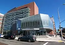
Medgar Evers College is an institution of higher education in the neighborhood.[68]
The orthodox Jewish community is serviced by gender-segregated schools. Among the girls schools are Beth Rivkah Academy, founded in 1941 by the sixth Lubavitcher Rebbe, Yosef Yitzchak Schneerson, as the oldest Chasidic school for girls;[69] the school now hosts preschool through higher learning institutions. Newer schools include Bnos Menachem, Bais Chaya Mushka, Bnos Chomesh and Chabad Girls Academy. The boys are educated at Oholei Torah, Yeshiva Tomchei Temimim Lubavitch, Cheder Ohr Menachem, Gan Academy, Darchei Menachem and various other smaller schools.[70]
Libraries
The Brooklyn Public Library (BPL) has three branches in Crown Heights:
- The Crown Heights branch, on the border with Flatbush/Prospect Lefferts Gardens, is located at 560 New York Avenue near Maple Street. The branch was built in 1958 as part of a plan by mayor Abraham Beame.[71]
- The Brower Park branch is located at 725 St. Marks Avenue between New York and Nostrand Avenues. The branch was built in 1963 under the Beame plan. When it opened, it was northern Brooklyn's first new library in four decades.[72]
- The Eastern Parkway branch and Eastern Parkway Learning Center is located at 1044 Eastern Parkway at Schenectady Avenue. It is a two-story, limestone-clad Carnegie library branch with 12,000 square feet (1,100 m2) of floor space. The branch was renovated at least four times, most recently in 2016.[73]
Transportation
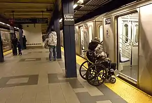
Crown Heights is served by the New York City Subway's IRT Eastern Parkway Line, with stations at Franklin Avenue (2, 3, 4, and 5 trains), Nostrand Avenue (3 train), Kingston Avenue (3 train), and Utica Avenue (3 and 4 trains). It is also served by the IRT Nostrand Avenue Line at President and Sterling Streets (2 and 5 trains). The subway's BMT Franklin Avenue Line, served by the S train contains stations at Botanic Garden and Park Place.[74] Just east of the Utica Avenue station, on the border with Brownsville, there is a park called Lincoln Terrace (also known as Arthur S. Somers Park), which slopes gently down toward the southern Brooklyn coastline; the IRT New Lots Line transitions from a tunnel to an elevated structure within this park.[75]
Several bus lines serve the area, including the B12, B14, B15, B17, B43, B44, B44 SBS, B45, B46, B46 SBS, B47 and B65.[76]
Recreation
Crown Heights has one botanical garden:
There are also four museums in Crown Heights:
Crown Heights has several parks:
- Prospect Park and Mount Prospect Park runs along Crown Heights' western edge.
- Brower Park
- St. John's Park and Recreation Center
- Hamilton Metz Field
- Wingate Park
- Parkside Playground
Landmarks
- 23rd Regiment Armory
- 770 Eastern Parkway (central headquarters of the Chabad-Lubavitch Hasidic movement)
- Crown Heights North Historic District
- Ebbets Field Apartments
- George W. Wingate High School
- Hunterfly Road Historic District
- Kol Israel Synagogue
- Medgar Evers College
- former Nassau Brewing Company
- Park Place Historic District
- St. Bartholomew's Protestant Episcopal Church and Rectory
Notable people
- Bob Arum (born 1931), founder and CEO of Top Rank, a professional boxing promotion company
- Robert S. Bennett (born 1939), attorney who represented President Bill Clinton during the Lewinsky scandal[77]
- William Bennett (born 1943), Secretary of Education under President Ronald Reagan[77]
- Uché Blackstock, physician
- Buckshot (born 1974), rapper
- Shirley Chisholm (1924-2005), educator and politician[78]
- Iris Cantor (born 1931), philanthropist
- Clive Davis (born 1932), music industry executive[79]
- I.A.L. Diamond (1920–88), comedy writer
- Dinah Abrahamson (1954-2013), author
- Dyme-A-Duzin (born 1992), rapper
- Israel Englander (born 1948), billionaire hedge fund manager.[80]
- Joseph Esposito (born 1950), NYC Emergency Management commissioner, started as a beat cop in Crown Heights[81]
- Avraham Fried (born 1959), Hasidic singer
- Yitzchak Ginsburg (born 1944), American-born Israeli rabbi
- Allen Grubman, entertainment lawyer
- Maggie Haberman, journalist[82]
- Jamie Hector (born 1975), actor, portrays Marlo Stanfield on the HBO series The Wire
- Sidney "Sonny" Hertzberg (1922–2005), professional basketball player
- Regina Herzlinger, professor at Harvard Business School[83]
- Gavriel Holtzberg (1979–2008), murdered Orthodox rabbi and Chabad emissary to Mumbai, India
- Simon Jacobson (born 1956), rabbi, author, journalist
- Yosef Yitzchak Jacobson (born 1972), rabbi and orator
- Harold S. Koplewicz (born 1953), child and adolescent psychiatrist
- Carol Laderman (1932–2010), medical anthropologist
- Nas (born 1973), famous hip-hop artist, songwriter, record producer and actor[84]
- Norman Mailer (1923–2007), novelist, journalist and author[85]
- Marty Markowitz (born 1945), former Brooklyn borough president[86]
- Matisyahu Miller (born 1979), reggae artist[87]
- Stephanie Mills (born 1957), singer[88]
- Mark Naison (born 1946), professor of history and former political activist
- Lemrick Nelson (born 1975), convicted of violating Yankel Rosenbaum's civil rights in his murder during the 1991 Crown Heights riot
- Linda Nochlin (1931-2017), art historian best known for her pioneering 1971 article "Why Have There Been No Great Women Artists?".[89]
- Mendy Pellin, Hasidic comedian[90]
- Noel Pointer (1954–1994), jazz violinist
- Aaron Raskin, religious leader, Chabad Lubavitch rabbi and author
- Kendall Schmidt (born 1990), television actor (Big Time Rush) and singer
- Menachem Mendel Schneerson (1902–94), the Rebbe of Chabad-Lubavitch
- Meyer Seewald (born 1988) community activist, founder of the Jewish Community Watch, an organization whose mission is the prevention of child sex abuses in the Orthodox community
- Allie Sherman (1923-2015), National Football League player and head coach
- Sholom Shuchat (born 1984), Chabad-Lubavitch rabbi, dayan, and posek[91]
- Carl Sigman (1909–2000), songwriter
- Beverly Sills (1929–2007), opera singer and administrator
- Mighty Sparrow (born 1935), Calypso musician from Trinidad/West Indies
- Susan McKinney Steward (1847–1918), first African American woman to earn medical degree in New York
- Aaron Swartz (1986–2013), computer programmer, writer, archivist, political organizer, and internet activist
- William L. Taylor (1931–2010), attorney and civil rights advocate[92]
- Simcha Weinstein (born 1975), author and rabbi
- Mendy Werdyger (born 1959), Hasidic Jewish singer, songwriter, and record store owner
- Yoni Z (born Yoni Zigelboum in 1991), Jewish recording artist, songwriter and entertainer[93]
In film
- Project 2x1, a 2013 documentary shot with Google Glass, features scenes shot by the Caribbean and Hasidic residents.[94][95]
- Crown Heights (2004), a television film by Jeremy Kagan for Showtime.[96]
- Crown Heights (2017)
- Brooklyn Babylon
References
- "NYC Planning | Community Profiles". communityprofiles.planning.nyc.gov. New York City Department of City Planning. Retrieved March 18, 2019.
- "NYC Planning | Community Profiles". communityprofiles.planning.nyc.gov. New York City Department of City Planning. Retrieved March 18, 2019.
- "Crown Heights neighborhood in New York". Retrieved August 13, 2018.
- "The Eastern District of Brooklyn" by Eugene Armbruster 1912 updated 1941.
- "Crown Heights" from the 1939 "WPA Guide to New York City"
- "NYPD – 77th Precinct". www.nyc.gov. New York City Police Department. Retrieved October 3, 2016.
- "NYPD – 71st Precinct". www.nyc.gov. New York City Police Department. Retrieved October 3, 2016.
- "Notes for: Jan Joris Jansen (Rapalje) De_Rapalie" from the Janssen Verheul families in Canada and Holland database
- "Crown Heights North Historic District: Designation Report Archived October 25, 2007, at the Wayback Machine" prepared by the New York City Landmarks Preservation Commission April 24, 2007 (pdf)
- "Chapter 3.1: Woodland to City Neighborhood: 300 Years of Change" by Jerome Krase, Brooklyn College Sociology Department "Self and Community in the City", University Press of America 1982
- Brooklyn Museum open collection Crow Hill Penitentiary gate
- Goldschmidt, Henry (2006). Race And Religion Among the Chosen Peoples of Crown Heights By Henry Goldschmidt. ISBN 9780813538976.
- Golenbock, Peter (2000). Bums: An oral history of the Brooklyn Dodgers. Lincolnwood, Ill: Contemporary Books.
- Edward S. Shapiro, "Interpretations of the Crown Heights riot." American Jewish History (2002) 90#2 pp: 97-122.
- Edward S. Shapiro, Crown Heights: Blacks, Jews, and the 1991 Brooklyn Riot (U. Press of New England, 2006).
- Yee, Vivian (November 27, 2015). "Gentrification in a Brooklyn Neighborhood Forces Residents to Move On". New York Times. Retrieved May 26, 2019.
- Croghan, Lore (May 9, 2012). "Art, fancy food and all-girl rock bands: Welcome to Crown Heights, the Hasidic SoHo". New York Daily News. Retrieved June 4, 2019.
- New York Community Media Alliance, May 9, 2007: "Desperately seeking an apartment: Haitians continue to double up as rents soar". Archived from the original on July 26, 2011. (Accessed on December 6, 2009)
- New York Times – City Room, November 16, 2007: Chan, Sewell (November 16, 2007). "Landlord Eviction Trick Backfired, Investigators Say". The New York Times. Retrieved April 30, 2010. (Accessed on December 6, 2009)
- INPRINT, August 10, 2004: "The Uncertain Fate of an Old Brooklyn Nook". (Accessed on December 6, 2009)
- Marsh, Ian, "Pressured to Move, Low-Income Tenants Resist Buyouts," Brooklyn Bureau (bkbureau.org), May 27, 2014
- "Isaac Hager takes Crown Heights rezoning off the table … for now developer to take second look at rezoning lots for 565 apartments". The Real Deal. April 20, 2017.
- Croghan, Lore (April 18, 2019). "Judge issues restraining order to halt development near Brooklyn Botanic Garden". Brooklyn Eagle.
- Levin, Chaim; Dreyfus, Hanna (March 9, 2017). "Crown Heights Now Artisanal Kosher Haven". The Jewish Week. Retrieved May 26, 2019.
- "Jewish Man Assaulted as Part of Sick 'Knockout' Game". CrownHeights.info. November 10, 2013.
- "Police Added in Brooklyn Neighborhood Amid "Knockout Game" Attacks". WNBC. November 20, 2013. Retrieved November 23, 2013.
- Jonathan Mark (November 20, 2013). "Mark, Jonothan. 'Knockout' Attacks A Concern. The Jewish Week. Nov. 10, 2013". Thejewishweek.com. Retrieved November 26, 2013.
- ""Brooklyn Jewish leaders offer 1500 reward for knockout game arrests". DNA.info. Nov. 25, 2013". Dnainfo.com. November 22, 2013. Archived from the original on November 26, 2013. Retrieved November 26, 2013.
- "NYPD investigating Crown Heights 'knockout' attacks on Jews as possible hate crimes – Daily News". Nydailynews.com. Archived from the original on November 26, 2013. Retrieved November 26, 2013.
- "Yanover, Yoni. "Crown Heights Knockout-the-Jew attacks serial hate crimes". The Jewish Press. Nov. 14, 2013". Jewishpress.com. Retrieved November 26, 2013.
- COLlive reporter. "A Jewish Response to Knockout." COLlive.com. January 29, 2014. Accessed February 2, 2014.
- New York City Neighborhood Tabulation Areas*, 2010, Population Division - New York City Department of City Planning, February 2012. Accessed June 16, 2016.
- "West Indian-American Day Carnival Association".
- "Archived copy". Archived from the original on May 10, 2018. Retrieved May 10, 2018.CS1 maint: archived copy as title (link)
- Rule, Sheila (April 15, 1994). "The Voices and Faces of Crown Heights". The New York Times. Retrieved November 26, 2007.
- Table PL-P5 NTA: Total Population and Persons Per Acre - New York City Neighborhood Tabulation Areas*, 2010, Population Division - New York City Department of City Planning, February 2012. Accessed June 16, 2016.
- Table PL-P3A NTA: Total Population by Mutually Exclusive Race and Hispanic Origin - New York City Neighborhood Tabulation Areas*, 2010, Population Division - New York City Department of City Planning, March 29, 2011. Accessed June 14, 2016.
- "Crown Heights and Prospect Heights (Including Crown Heights, Prospect Heights and Weeksville)" (PDF). nyc.gov. NYC Health. 2018. Retrieved March 2, 2019.
- "2016-2018 Community Health Assessment and Community Health Improvement Plan: Take Care New York 2020" (PDF). nyc.gov. New York City Department of Health and Mental Hygiene. 2016. Retrieved September 8, 2017.
- "New Yorkers are living longer, happier and healthier lives". New York Post. June 4, 2017. Retrieved March 1, 2019.
- "NYC-Brooklyn Community District 8--Crown Heights North & Prospect Heights PUMA, NY". Retrieved July 17, 2018.
- "South Crown Heights and Lefferts Gardens (Including Prospect Lefferts Gardens, South Crown Heights and Wingate)" (PDF). nyc.gov. NYC Health. 2018. Retrieved March 2, 2019.
- "NYC-Brooklyn Community District 9--Crown Heights South, Prospect Lefferts & Wingate PUMA, NY". Retrieved July 17, 2018.
- "U.S. House Election Results 2018". The New York Times. January 28, 2019. Retrieved February 21, 2019.
- "2012 Senate District Maps: New York City" (PDF). The New York State Legislative Task Force on Demographic Research and Reapportionment. 2012. Retrieved November 17, 2018.
- "NY Senate District 19". NY State Senate. Retrieved January 18, 2019.
- "2012 Assembly District Maps: New York City" (PDF). The New York State Legislative Task Force on Demographic Research and Reapportionment. 2012. Retrieved November 17, 2018.
- "New York State Assembly Member Directory". Assembly Member Directory. Retrieved March 4, 2019.
- "District 35". New York City Council. March 25, 2018. Retrieved March 4, 2019.
- "District 36". New York City Council. March 25, 2018. Retrieved March 4, 2019.
- "Find Your Precinct and Sector - NYPD". www.nyc.gov. Retrieved March 3, 2019.
- "Prospect Heights & Crown Heights – DNAinfo.com Crime and Safety Report". www.dnainfo.com. Archived from the original on March 6, 2019. Retrieved October 6, 2016.
- "Prospect Lefferts Gardens & Crown Heights – DNAinfo.com Crime and Safety Report". www.dnainfo.com. Archived from the original on April 15, 2017. Retrieved October 6, 2016.
- "77th Precinct CompStat Report" (PDF). www.nyc.gov. New York City Police Department. Retrieved July 22, 2018.
- "71st Precinct CompStat Report" (PDF). www.nyc.gov. New York City Police Department. Retrieved July 22, 2018.
- "FDNY Firehouse Listing – Location of Firehouses and companies". NYC Open Data; Socrata. New York City Fire Department. September 10, 2018. Retrieved March 14, 2019.
- "Engine Company 234/Ladder Company 123/Battalion 3". FDNYtrucks.com. Retrieved March 2, 2019.
- "Firehouse". FDNY Rescue 2. February 1, 1925. Retrieved March 4, 2019.
- "Engine Company 280/Ladder Company 132". FDNYtrucks.com. Retrieved March 2, 2019.
- "Engine Company 227". FDNYtrucks.com. Retrieved March 2, 2019.
- New York City Health Provider Partnership Brooklyn Community Needs Assessment: Final Report, New York Academy of Medicine (October 3, 2014).
- "Flatbush, New York City-Brooklyn, New York Zip Code Boundary Map (NY)". United States Zip Code Boundary Map (USA). Retrieved March 27, 2019.
- "Location Details: Saint Johns Place". USPS.com. Retrieved March 5, 2019.
- "Location Details: James E Davis". USPS.com. Retrieved March 5, 2019.
- "Crown Heights / Prospect Heights – BK 08" (PDF). Furman Center for Real Estate and Urban Policy. 2011. Retrieved October 5, 2016.
- "S. Crown Heights / Lefferts Gardens – BK 09" (PDF). Furman Center for Real Estate and Urban Policy. 2011. Retrieved October 5, 2016.
- "Empower Charter School Archived December 12, 2013, at the Wayback Machine"
- Campus Map and Directions, Medgar Evers College. Accessed October 29, 2019.
- "Overpass Aided School Top Goal", COL Live, December 9, 2018. Accessed October 29, 2019. "Beth Rivkah was founded in 1941, as the world’s first Chassidic girls’ school."
- "Spotlight on Schools: Yeshiva Darchai Menachem", Hidden Sparks. Accessed October 29, 2019. "Yeshiva Darchai Menachem is a unique boys’ yeshiva in Crown Heights, Brooklyn that creates a learning environment that supports and celebrates its students, many of whom have behavioral and academic challenges."
- "History". Brooklyn Public Library. November 7, 2016. Retrieved February 23, 2019.
- "History". Brooklyn Public Library. November 7, 2016. Retrieved February 23, 2019.
- "Eastern Parkway Library". Brooklyn Public Library. August 19, 2011. Retrieved February 21, 2019.
- "Subway Map" (PDF). Metropolitan Transportation Authority. October 21, 2019. Retrieved January 18, 2018.
- "Lincoln Terrace / Arthur S. Somers Park : NYC Parks". New York City Department of Parks & Recreation. Retrieved October 3, 2016.
- "Brooklyn Bus Map" (PDF). Metropolitan Transportation Authority. October 2020. Retrieved December 1, 2020.
- Bennett, Robert S. In the Ring: The Trials of a Washington Lawyer, p. 4. Crown Publishers, 2008. ISBN 9780307394439. Accessed November 2, 2017. "I was the first child of Nancy Walsh Bennett and F. Robert Bennett. Mother was a housewife and Dad worked for a bank. We lived at 698 St. Marks Avenue in what is now known as the Bedford-Stuyvesant section." Note that Bennett inaccurately describes the 698 St. Marks Avenue address as being in Bedford-Stuyvesant (not Crown Heights).
- "Archived copy" (PDF). Archived from the original (PDF) on February 5, 2018. Retrieved December 4, 2018.CS1 maint: archived copy as title (link)
- Duffy, Thom. "'Celebrate Brooklyn' Readies Summer Lineup", Billboard (magazine), May 7, 2004. Accessed October 27, 2007. "My life totally revolved around Brooklyn, says Davis, recalling his boyhood in a working-class Jewish neighborhood of Crown Heights, watching the Brooklyn Dodgers play at Ebbet's Field and listening to Martin Block's Make Believe Ballroom on WNEW."
- Strasburg, Jenny. "Hedge-Fund Titan Englander Preps for Future in Sale Talks", The Wall Street Journal, July 26, 2011. Accessed January 25, 2020. ""A child of the Crown Heights neighborhood of Brooklyn, Mr. Englander, the devoutly Jewish head of a firm with a 22-year history. A child of the Crown Heights neighborhood of Brooklyn, Mr. Englander now lives in Manhattan, but still sometimes crosses the East River to attend services with rabbis and scholars he considers close confidantes."
- "Mayor names ex-NYPD chief head of Office of Emergency Management". Retrieved October 3, 2016.
- Haberman, Maggie (April 19, 2016). "Our Woman in New York: Primary Day, at Last". The New York Times. The New York Times. Retrieved April 19, 2016.
- Murphy, Anne. "The Accountant Is In". Retrieved October 3, 2016.
- Ahmed, Insanul. "50 Things You Didn't Know About Nas", Complex (magazine). December 3, 2012. Accessed November 1, 2017. "He lived in Crown Heights, Brooklyn before he lived in Queensbridge."
- McGrath, Charles. "Norman Mailer, Towering Writer With a Matching Ego, Dies at 84", The New York Times, November 11, 2007. Accessed November 1, 2017. "When Norman was 9, the family moved to Crown Heights, in Brooklyn. Pampered and doted on, he excelled at both Public School 161 and Boys High School, from which he graduated in 1939."
- Mead, Rebecca. "Mr. Brooklyn; Marty Markowitz-the man, the plan, the arena.", The New Yorker, April 25, 2005. Accessed August 3, 2016. "Markowitz was one of those Brooklyn children who rarely went to Manhattan: he grew up in Crown Heights, where his father worked as a waiter in a kosher delicatessen; his main entertainment was hanging out on the streets with other kids. His father died when he was nine, and several years later Markowitz's widowed mother moved to public housing in Sheepshead Bay with Marty and his two younger sisters."
- Morrison, Tim. "Matisyahu: The Former 'Hasidic Reggae Superstar' Talks to TIME; His trademark beard and forelocks are gone, and his music is taking a new direction. Matisyahu tells TIME about his new album, his faith and how he defines himself now.", Time (magazine), July 16, 2012. Accessed November 1, 2017. "It’s been a year of transition for Matisyahu. Since the beginning of 2011 he’s gone from being primarily known for his blistering, rock-influenced live reggae shows to the man behind the global pop anthem ‘One Day’ — NBC’s official song of the Vancouver Olympics. He’s left behind the Hasidic Jewish enclave of Crown Heights, Brooklyn, and moved to Los Angeles."
- Telpha, Carol. "Neighborhoods: Close-Up on Crown Heights Archived December 10, 2007, at the Wayback Machine", The Village Voice, December 12, 2002. Accessed October 18, 2007. "Actress and singer Stephanie Mills and rapper Skoob of Das EFX are Crown Heights natives."
- Smith, Roberta. "Linda Nochlin, 86, Groundbreaking Feminist Art Historian, Is Dead", The New York Times, November 1, 2017. Accessed November 1, 2017. "She was born Linda Natalie Weinberg on Jan. 30, 1931, in Brooklyn and grew up in Crown Heights as a member of a wealthy extended family."
- Beyer, Gregory. "Comedy Central, by Way of the Torah", The New York Times. January 13, 2008. Accessed November 1, 2017. "Mr. Pellin, a garrulous 25-year-old, was beginning yet another segment as the host of The Mendy Report, an Internet news broadcast on the Web site ChabadTube.com. He runs the broadcast out of his childhood bedroom, now cluttered with production lights and videotape cassettes, in his family’s fourth-floor walk-up apartment on Kingston Avenue in a Hasidic enclave of Crown Heights, Brooklyn."
- Staff. (November 19, 2015 ) "Rabbi Receives No-Jail Sentence in Forced ‘Get’ Case", Crown Heights.info. Retrieved July 9, 2019.
- Martin, Douglas. "William Taylor, Vigorous Rights Defender, Dies at 78", The New York Times, June 29, 2010. Accessed June 30, 2010.
- Miller, Rochelle Maruch. "Yoni Z.: Raising the Bar In Jewish Music", 5 Towns Jewish Times, October 3, 2018. Accessed November 21, 2018. "Although the journey to success was long and challenging, the congenial Crown Heights resident, who is a member of the Chabad community, remained undeterred."
- Sharp, Sonja. Crown Heights Documentary Claims to be First Ever Shot With Google Glass. DNAInfo.com. Oct 7, 2013. Archived November 4, 2014, at the Wayback Machine
- Brooklyn Film & Arts Festival Screening: "Brooklyn Realities – Documented". Columbia.edu.
- "Movie Reviews". Retrieved October 3, 2016.
Further reading
| Wikimedia Commons has media related to Crown Heights, Brooklyn. |
- Race and Religion among the Chosen Peoples of Crown Heights, by Henry Goldschmidt (Rutgers University Press, 2006)
- "Strolls Upon Old Lines: Crow Hill and Some of Its Suggestions" from the Brooklyn Eagle December 9, 1888
- Klockenbrink, Myra (January 20, 1985). "If You're Thinking of Living In: Crown Heights". The New York Times. Retrieved July 14, 2014.
