Putana (volcano)
Putana, sometimes referred to as Jorqencal or Machuca, is a volcano on the border between Bolivia and Chile and close to the Sairecabur volcanic complex. Part of the Central Volcanic Zone of the Andes, its summit is 5,890 metres (19,320 ft) above sea level and contains a summit crater with two smaller craters nested within it. Beneath the summit, the volcano features a number of lava domes and lava flows, some of which originated in flank vents.
| Putana | |
|---|---|
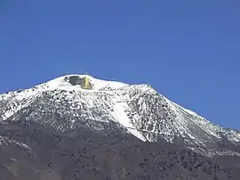 Putana volcano, with the summit fumaroles, sulfur deposits and the summit road all visible | |
| Highest point | |
| Elevation | 5,890 m (19,320 ft) [1] |
| Coordinates | 22.557°S 67.853°W [1] |
| Geography | |
| Location | Bolivia-Chile |
| Parent range | Andes |
| Geology | |
| Mountain type | Stratovolcano |
While the occurrence of historical activity is unclear (aside from an episode in 2009–2010 where the edifice was uplifted by 4 centimetres (1.6 in)), the volcano features vigorous fumarolic activity that creates a large plume of gas above the summit. Sulfur deposited by the fumaroles has been mined.
Context
Putana lies on the border between Chile and Bolivia,[2] and is also known as Jorgencal, Jorjencal or Machuca.[3] The area is remote and difficult to access and thus poorly studied.[4]
Volcanism in the Central Andes is the consequence of the subduction of the Nazca Plate beneath the South American Plate and occurs in form of the 1,500 kilometres (930 mi) long Central Volcanic Zone,[4] one of four volcanic belts in the Andes. The Peruvian and the Pampean "flat slab" segments separate this volcanic belt from its neighbours, the Northern Volcanic Zone to the north and the Southern Volcanic Zone south respectively.[5]
Putana is part of the Central Volcanic Zone, which aside from this volcano contains a number of large calderas associated with silicic volcanism. Over 13 volcanoes in the Central Volcanic Zone have been active in historical time, out of about 69 with evidence of Holocene activity.[5] Of these volcanoes Láscar is the most active volcano in the Central Volcanic Zone; a major eruption occurred there in 1993.[4]
The volcano
Putana is a 5,890 metres (19,320 ft) high volcano elongated from north to south.[1] It is constructed by lavas and pyroclastic material,[6] with effusive products such as lava domes and lava flows forming the bulk of the edifice. Most lava flows were viscous enough that they do not exceed 3 kilometres (1.9 mi) of length,[1] older flows are longer.[7] Younger lava flows occur on the western slope,[8] and some lava flows appear to be younger than the last glacial age.[2]
The summit contains a 500 metres (1,600 ft) wide summit crater which itself contains two smaller craters, one is 300 metres (980 ft) wide and lies on the northeastern side and the other with a width of 130 metres (430 ft) is in the centre of the summit crater.[6] Lava flows/lava domes are emplaced in the southern part of the main summit crater.[9] Additional adventive vents occur on the slopes of Putana;[2] a particularly noticeable fan-shaped flow northwest of Putana originated in such a flank vent.[8]
The volcano forms part of a complex of ash flows and cones which covers a surface area of 600 square kilometres (230 sq mi).[10] Putana was constructed on the Purificar and Tatio ignimbrites of Pliocene-Pleistocene age;[6] the whole edifice is constructed around a pre-Holocene volcano.[1]
Volcanic rocks found at Putana include basaltic andesite, andesite and dacite.[6] Minerals contained in the rocks include pyroxene in the andesites and biotite and hornblende in the dacites.[7]
Neighbouring mountains include the Cerros Aguita Blanca in the east, Cerro Amarillo in the southeast, Curiquinca south-southwest of Putana[11] and Escalante and Cerro Colorado to the south-southwest.[12] Curiquinca, El Apagado and Sairecabur together form a major volcanic group.[7]
The slopes of Putana drain north into the west-flowing Río Aguita Blanca, east into the Salar de Chalviri and southeast into the Río Blanco and from there into the Laguna Verde-Laguna Blanca system.[11] The Río Putana originates on the northern flank of Putana, which forms its headwaters. It joins with the Río Jauna to form the Río Grande, which in turn joins the Río Salado to form the Río San Pedro de Atacama that eventually drains into the Salar de Atacama.[13]
Eruptive history
The geologic history of Putana is unknown, due to the lack of detailed studies on the subject.[2] The last eruption at Putana was reported from the late 19th century;[2] one date given is 1810[14] with an uncertainty of 10 years[15] and the eruption was described as a major one.[1] Reports of an eruption on 2 July 1972 ± 182 days are uncertain,[15] and other opinions say that there was no historical eruption there.[1]
Between late 2009 and early 2010, the volcano underwent an episode of deformation accompanied by earthquake swarms. Based on modelling, about 300,000 cubic metres (11,000,000 cu ft) of magma were intruded at a depth of 1 kilometre (0.62 mi) during this episode, lifting the ground by about 4 centimetres (1.6 in) over a diameter of 5 kilometres (3.1 mi).[10] Aside from this episode, Putana is seismically active, both in form of individual events, seismic swarms and triggered earthquakes; the 2010 Maule earthquake was accompanied by seismicity at Putana.[16]
Fumaroles
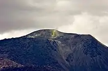
Putana features active fumaroles, which generate a 100–500 metres (330–1,640 ft) high plume above the volcano. This plume was seen as far back as the 19th century. The fumaroles have different shapes, from vents that are only centimetres wide to large 10 metres (33 ft) wide openings. They occur in groups, in total four separate fumarole fields, two within the northeastern crater, one in the summit crater and one outside of the summit crater[6] where about 30 individual fumaroles were reported in 1952.[17] These fumaroles are visible as a thermal anomaly from space, but it is relatively weak with a temperature anomaly of only 5 K (9.0 °F).[2]
These fumaroles exhale a mixture of hydrogen sulfide and sulfur dioxide,[18] which is produced at a rate of 20,000–22,000 tonnes per year (55–60 t/d).[19] In addition they contain hydrogen, hydrogen chloride, hydrogen fluoride and nitrogen, while carbon monoxide, methane and oxygen are only minor components.[18] Temperatures of 82–88 °C (180–190 °F) have been measured, and the source appears to have temperatures of up to 500 °C (932 °F).[10] The composition of the fumaroles indicates that the gases are ultimately of mainly magmatic origin,[20] but interact with a slightly colder hydrothermal system before reaching the surface.[21]
The fumarolic activity at Putana lays down deposits of sulfur on the volcano,[22] including one 76 metres (250 ft) high cliff that was reported to be covered with sulfur in 1952.[23] This sulfur was mined at the summit of the volcano, which is thus accessible by a road.[8] Putana sulfur was noted to be extremely pure in that same year.[24] It has been mined and transported down by truck from elevations of 5,600 metres (18,500 ft), one of the highest altitudes at which motor vehicles have been used.[25] The Carnen sulfur mine is found on the southeastern flank, and more mines are found on neighbouring mountains.[11] Operations in the Putana mine ceased in 1972.[26]
References
- "Putana". Global Volcanism Program. Smithsonian Institution.
- Stebel et al. 2015, p. 113.
- "Putana". Global Volcanism Program. Smithsonian Institution., Synonyms & Subfeatures Archived 2017-11-07 at the Wayback Machine
- Tassi et al. 2011, p. 121.
- Henderson & Pritchard 2013, p. 1358.
- Tassi et al. 2011, p. 122.
- "Putana". volcano.oregonstate.edu. Archived from the original on 2015-02-16. Retrieved 2017-06-11.
- "Putana". Global Volcanism Program. Smithsonian Institution., Photo Gallery Archived 2017-11-07 at the Wayback Machine
- Tassi et al. 2011, p. 124.
- Henderson & Pritchard 2013, p. 1371.
- "Volcan Juriques" (PDF). Instituto Geográfico Militar Bolivia. 2016-10-21. Archived from the original (PDF) on 2018-02-26. Retrieved 26 February 2018.
- "Putana TM Image Information". volcano.oregonstate.edu. Archived from the original on 2015-02-15. Retrieved 2017-06-11.
- Niemeyer, Hans F. (1980). Segunda Región de Antofagasta (PDF) (Report). Hoyas hidrográficas de Chile (in Spanish). pp. 171–173. Archived from the original (PDF) on 2016-03-04. Retrieved 2018-10-27.
- Pritchard et al. 2014, p. 99.
- "Putana". Global Volcanism Program. Smithsonian Institution., Eruptive History Archived 2017-11-07 at the Wayback Machine
- Pritchard et al. 2014, p. 98.
- Rudolph 1952, p. 568.
- Tassi et al. 2011, p. 126.
- Stebel et al. 2015, p. 119.
- Tassi et al. 2011, p. 128.
- Tassi et al. 2011, p. 132.
- Rudolph 1952, pp. 568–569.
- Rudolph 1952, p. 567.
- Rudolph 1952, pp. 565.
- Rudolph 1952, pp. 563–564.
- Calamatta, George Serracino; Landsberger, Rubén Federico Stehberg (1975). "Vida pastoril en la precordillera andina (Guatin, San Pedro de Atacama, Chile)". Estudios Atacameños. Arqueología y Antropología Surandinas. (in Spanish) (3): 82. doi:10.22199/S07181043.1975.0003.00011. ISSN 0718-1043.
Sources
- Henderson, S. T.; Pritchard, M. E. (2013-05-01). "Decadal volcanic deformation in the Central Andes Volcanic Zone revealed by InSAR time series". Geochemistry, Geophysics, Geosystems. 14 (5): 1358–1374. doi:10.1002/ggge.20074. ISSN 1525-2027.
- Pritchard, M. E.; Henderson, S. T.; Jay, J. A.; Soler, V.; Krzesni, D. A.; Button, N. E.; Welch, M. D.; Semple, A. G.; Glass, B. (2014-06-01). "Reconnaissance earthquake studies at nine volcanic areas of the central Andes with coincident satellite thermal and InSAR observations". Journal of Volcanology and Geothermal Research. 280: 90–103. doi:10.1016/j.jvolgeores.2014.05.004.
- Rudolph, William E. (1952). "Sulphur in Chile". Geographical Review. 42 (4): 562–590. doi:10.2307/211839. JSTOR 211839.
- Stebel, K.; Amigo, A.; Thomas, H.; Prata, A. J. (2015-07-15). "First estimates of fumarolic SO2 fluxes from Putana volcano, Chile, using an ultraviolet imaging camera". Journal of Volcanology and Geothermal Research. 300: 112–120. doi:10.1016/j.jvolgeores.2014.12.021.
- Tassi, Franco; Aguilera, Felipe; Vaselli, Orlando; Darrah, Thomas; Medina, Eduardo (2011-06-30). "Gas discharges from four remote volcanoes in northern Chile (Putana, Olca, Irruputuncu and Alitar): a geochemical survey". Annals of Geophysics. 54 (2). doi:10.4401/ag-5173. ISSN 1593-5213.
Bibliography
- González-Ferrán, Oscar (1995). Volcanes de Chile. Santiago, Chile: Instituto Geográfico Militar. p. 640 pp. ISBN 978-956-202-054-1.(Spanish)
External links
- SI Google Earth Placemarks – Smithsonian Institution Global Volcanism Program: Download placemarks with SI Holocene volcano-data.
- AVA images
- Additional images
- Google Earth view