Raisinville Township, Michigan
Raisinville Township is a civil township of Monroe County in the U.S. state of Michigan. The population was 5,816 at the 2010 census.
Raisinville Township, Michigan | |
|---|---|
 | |
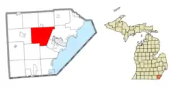 Location within Monroe County | |
 Raisinville Township Location within the state of Michigan  Raisinville Township Raisinville Township (the United States) | |
| Coordinates: 41°56′49″N 83°31′48″W | |
| Country | United States |
| State | Michigan |
| County | Monroe |
| Government | |
| • Supervisor | Susan Blanchette |
| • Clerk | Brenda Fetterly |
| Area | |
| • Total | 48.54 sq mi (125.7 km2) |
| • Land | 48.14 sq mi (124.7 km2) |
| • Water | 0.40 sq mi (1.0 km2) |
| Elevation | 630 ft (192 m) |
| Population (2010) | |
| • Total | 5,816 |
| • Density | 120.8/sq mi (46.6/km2) |
| Time zone | UTC-5 (Eastern (EST)) |
| • Summer (DST) | UTC-4 (EDT) |
| ZIP code(s) | |
| Area code(s) | 734 |
| FIPS code | 26-66900[1] |
| GNIS feature ID | 1626951[2] |
| Website | Official website |
Geography
According to the United States Census Bureau, the township has a total area of 48.54 square miles (125.7 km2), of which 48.14 square miles (124.7 km2) is land and 0.40 square miles (1.0 km2) (0.82%) is water.[3]
Communities
- East Raisinville was a community in the eastern part of the township at 41°56′14″N 83°27′59″W. East Raisinville had its own post office named Atkinson from 1829 to 1838 and renamed East Raisinville from 1838 to 1868. East Raisinville also had a railway station.[4][5]
- Grape was a community located in the central portion of the township at 41°57′49″N 83°32′22″W.[6] The community had its own post office from 1887 to 1906.[7]
Demographics
As of the census[1] of 2000, there were 4,896 people, 1,691 households, and 1,423 families residing in the township. The population density was 101.6 per square mile (39.2/km2). There were 1,762 housing units at an average density of 36.6 per square mile (14.1/km2). The racial makeup of the township was 97.94% White, 0.49% African American, 0.16% Native American, 0.25% Asian, 0.31% from other races, and 0.86% from two or more races. Hispanic or Latino of any race were 1.21% of the population.
There were 1,691 households, out of which 36.8% had children under the age of 18 living with them, 74.1% were married couples living together, 6.7% had a female householder with no husband present, and 15.8% were non-families. 13.5% of all households were made up of individuals, and 6.0% had someone living alone who was 65 years of age or older. The average household size was 2.88 and the average family size was 3.16.
In the township the population was spread out, with 26.6% under the age of 18, 8.0% from 18 to 24, 27.5% from 25 to 44, 27.7% from 45 to 64, and 10.3% who were 65 years of age or older. The median age was 38 years. For every 100 females, there were 102.8 males. For every 100 females age 18 and over, there were 101.0 males.
The median income for a household in the township was $62,734, and the median income for a family was $69,896. Males had a median income of $50,727 versus $29,459 for females. The per capita income for the township was $26,520. About 1.4% of families and 2.9% of the population were below the poverty line, including 1.1% of those under age 18 and 3.9% of those age 65 or over.
References
Notes
- "U.S. Census website". United States Census Bureau. Retrieved 2008-01-31.
- U.S. Geological Survey Geographic Names Information System: Raisinville Township, Michigan
- "Michigan: 2010 Population and Housing Unit Counts 2010 Census of Population and Housing" (PDF). 2010 United States Census. United States Census Bureau. September 2012. p. 34 Michigan. Retrieved July 22, 2020.
- U.S. Geological Survey Geographic Names Information System: East Raisinville Post Office (historical)
- Romig 1986, p. 172.
- U.S. Geological Survey Geographic Names Information System: Grape
- U.S. Geological Survey Geographic Names Information System: Grape Post Office (historical)
Sources
- Romig, Walter (October 1, 1986) [1973]. Michigan Place Names: The History of the Founding and the Naming of More Than Five Thousand Past and Present Michigan Communities. Great Lakes Books Series (Paperback). Detroit, Michigan: Wayne State University Press. ISBN 978-0-8143-1838-6.
Municipalities and communities of Monroe County, Michigan, United States | ||
|---|---|---|
| Cities | 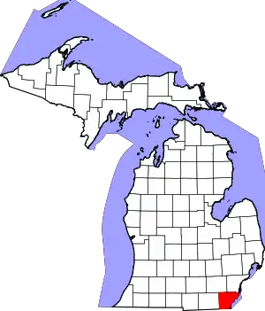 Map of Michigan highlighting Monroe County | |
| Villages | ||
| Charter townships | ||
| Civil townships | ||
| CDPs | ||
| Other unincorporated communities | ||
| Ghost towns | ||
| Footnotes | ‡This populated place also has portions in an adjacent county or counties | |
| ||