Stony Point, Michigan
Stony Point is an unincorporated community and census-designated place (CDP) in Monroe County in the U.S. state of Michigan. The population was 1,724 at the 2010 census.[3] The CDP is located within Frenchtown Charter Township.
Stony Point, Michigan | |
|---|---|
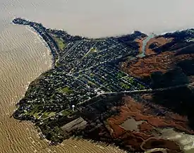 Stony Point from the air, looking southwest. | |
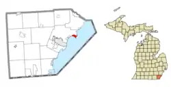 Location within Monroe County | |
 Stony Point Location within the state of Michigan  Stony Point Stony Point (the United States) | |
| Coordinates: 41°56′29″N 83°15′54″W | |
| Country | United States |
| State | Michigan |
| County | Monroe |
| Township | Frenchtown |
| Area | |
| • Total | 1.12 sq mi (2.9 km2) |
| • Land | 1.11 sq mi (2.9 km2) |
| • Water | 0.01 sq mi (0.03 km2) |
| Elevation | 577 ft (176 m) |
| Population (2010) | |
| • Total | 1,724 |
| • Density | 1,553.2/sq mi (599.7/km2) |
| Time zone | UTC-5 (Eastern (EST)) |
| • Summer (DST) | UTC-4 (EDT) |
| ZIP code(s) | 48166 (Newport) |
| Area code(s) | 734 |
| FIPS code | 26-76720[1] |
| GNIS feature ID | 0638920[2] |
Geography
According to the United States Census Bureau, the CDP has a total area of 1.12 square miles (2.9 km2), of which 1.11 square miles (2.9 km2) is land and 0.01 square miles (0.026 km2) (0.89%) is water.[3]
The community is the shores of Lake Erie about 7 miles (11 km) northeast of downtown Monroe. The area defined by the CDP is bounded on the west by Burke Road, on the northwest by Brest Road, and on the north by Point aux Peaux Road. The CDP of Woodland Beach is about 3 miles (5 km) to the west. The Fermi 2 Nuclear Power Plant is adjacent to the north.
Demographics
At the 2000 census,[1] there were 1,775 people, 616 households and 492 families residing in the CDP. The population density was 1,553.6 per square mile (601.2/km2). There were 674 housing units at an average density of 589.9 per square mile (228.3/km2). The racial makeup of the CDP was 96.17% White, 0.56% African American, 1.30% Native American, 0.34% Asian, 0.11% Pacific Islander, 0.51% from other races, and 1.01% from two or more races. Hispanic or Latino of any race were 2.25% of the population.
There were 616 households, of which 43.7% had children under the age of 18 living with them, 63.1% were married couples living together, 11.0% had a female householder with no husband present, and 20.1% were non-families. 16.1% of all households were made up of individuals, and 5.5% had someone living alone who was 65 years of age or older. The average household size was 2.88 and the average family size was 3.23.
30.5% of the population were under the age of 18, 7.6% from 18 to 24, 33.6% from 25 to 44, 21.5% from 45 to 64, and 6.8% who were 65 years of age or older. The median age was 32 years. For every 100 females, there were 109.1 males. For every 100 females age 18 and over, there were 103.1 males.
The median household income was $49,167 and the median family income was $59,583. Males had a median income of $46,542 compared with $30,385 for females. The per capita income for the CDP was $22,667. About 3.3% of families and 4.2% of the population were below the poverty line, including 3.3% of those under age 18 and 5.5% of those age 65 or over.
References
- "U.S. Census website". United States Census Bureau. Retrieved 2008-01-31.
- U.S. Geological Survey Geographic Names Information System: Stony Point, Michigan
- "Michigan: 2010 Population and Housing Unit Counts 2010 Census of Population and Housing" (PDF). 2010 United States Census. United States Census Bureau. September 2012. p. 34 Michigan. Retrieved May 1, 2020.
Municipalities and communities of Monroe County, Michigan, United States | ||
|---|---|---|
| Cities |  Map of Michigan highlighting Monroe County | |
| Villages | ||
| Charter townships | ||
| Civil townships | ||
| CDPs | ||
| Other unincorporated communities | ||
| Ghost towns | ||
| Footnotes | ‡This populated place also has portions in an adjacent county or counties | |
| ||