Ranchot
Ranchot is a commune in the Jura department in the Bourgogne-Franche-Comté region in eastern France.
Ranchot | |
|---|---|
 The town hall and bakery in Ranchot | |
Location of Ranchot 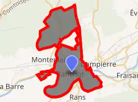
| |
 Ranchot  Ranchot | |
| Coordinates: 47°09′03″N 5°43′23″E | |
| Country | France |
| Region | Bourgogne-Franche-Comté |
| Department | Jura |
| Arrondissement | Dole |
| Canton | Mont-sous-Vaudrey |
| Government | |
| • Mayor (2014–2020) | Éric Montignon |
| Area 1 | 6.91 km2 (2.67 sq mi) |
| Population (2017-01-01)[1] | 495 |
| • Density | 72/km2 (190/sq mi) |
| Time zone | UTC+01:00 (CET) |
| • Summer (DST) | UTC+02:00 (CEST) |
| INSEE/Postal code | 39451 /39700 |
| Elevation | 209–262 m (686–860 ft) |
| 1 French Land Register data, which excludes lakes, ponds, glaciers > 1 km2 (0.386 sq mi or 247 acres) and river estuaries. | |
Geography
Ranchot is a small Jura village on the Doubs river. It is situated on the D673 (previously Route nationale 73) between Dole and Besançon, 5 km from the A36 autoroute junction 2.1.
Population
|
|
History
There is evidence of Gallo-Roman occupation (Roman roads in certain fields in the commune). In the 13th century, Ranchot was made a dependendence of Rans. The village was devastated by wars and plague in the 16th and 17th centuries.
See also
References
- "Populations légales 2017". INSEE. Retrieved 6 January 2020.
| Wikimedia Commons has media related to Ranchot. |
| Authority control |
|
|---|
This article is issued from Wikipedia. The text is licensed under Creative Commons - Attribution - Sharealike. Additional terms may apply for the media files.
