River Crane, London
The River Crane, a tributary of the River Thames, runs through part of west London, England, historically the former county of Middlesex. The Crane flows 8.5 miles (13.6 km) through three London boroughs: Hillingdon, Hounslow and Richmond upon Thames. The drainage basin is heavily urbanised but the immediate old flood-meadows of the Crane Valley are a main "river corridor" in London – a continuous belt of semi-natural habitat. In common with many urban rivers, the Crane's form has been greatly altered, in its case over centuries, by river engineering: widening, narrowing, straightening, dredging, supplementing, adding a discharge channel, and bank reinforcement.
| Crane | |
|---|---|
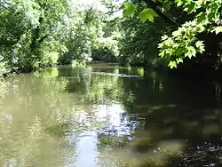 River Crane in Crane Park Whitton below the nature reserve and powder mills site | |
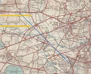 Map of 1930s showing most of the river, until shortly before its end (two points discharge to the Thames) | |
| Location | |
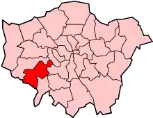
| Country | England |
| Counties | Greater London |
| Districts / Boroughs | London Boroughs of Hillingdon, Hounslow, Richmond upon Thames |
| Places with main adjoining parkland | Cranford, Hounslow Heath, Whitton |
| Physical characteristics | |
| Source | |
| • location | Hayes, Hillingdon |
| Mouth | River Thames |
• location | Isleworth |
| Length | 13.6 km (8.5 mi) |
| Discharge | |
| • location | Marsh Farm |
| • average | 0.54 m3/s (19 cu ft/s) |
| • minimum | 0.00 m3/s (0 cu ft/s)5 December 1982 |
| • maximum | 13.4 m3/s (470 cu ft/s)28 December 1979 |
| Discharge | |
| • location | Cranford Park |
| • average | 0.51 m3/s (18 cu ft/s) |
| Basin features | |
| Tributaries | |
| • right | Yeading Brook, Duke of Northumberland's River |
Location
The river's source is a point south of North Hyde Road in Hayes, Hillingdon, from where its course is near semi-circular to the south then east, joining the tidal Thames in two places: on the border of St Margarets with Isleworth and by Riverside Mill and Helene House, Isleworth.[1][2]
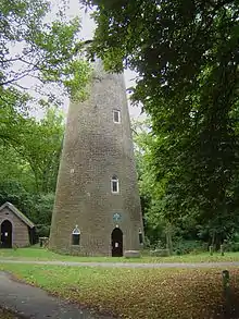
Passing through Cranford, the river crosses Cranford Countryside Park, skirts the eastern side of Heathrow Airport's car parks (formerly the Cranford Heath part of Hounslow Heath) and North Feltham,[3][4] the latter split from Hounslow West on the other bank by most of what is left of Hounslow Heath; here the (Upper) Duke of Northumberland's River joins the Crane.[lower-alpha 1] From this point, the Crane turns gradually east and passes through Crane Park (in Whitton, Twickenham). In Crane Park is the site of the Hounslow Powder Mills which were built in the 16th century and continued to make gunpowder until 1927. The mills have disappeared, but the Shot Tower still stands nearby.[5] The large millpool on an island above the mills is now a Local Nature Reserve, Crane Park Island.[6] The river then turns to the north-east in Twickenham to join the Thames at Isleworth with a distributary splitting off (forming a second section of the Duke's River) running through Kneller Gardens — the Crane itself flows east through Cole Park in Twickenham on the border of St Margarets, where it forms its border with Isleworth. The Duke's River is tidal for the short distance below the weir by the bridge in Church Street, Isleworth, to its confluence with the Thames.[5] Upstream in Isleworth it has been diverted to flow through Mogden Sewage Treatment Works, where it provides coolant for the power station. Treated effluent from the works is not discharged here but is instead piped to the Thames at Isleworth Ait.[7]
The Crane as to major parts delimits the London boroughs of
- Hillingdon and Hounslow.
- Hounslow and "Richmond".[lower-alpha 2][1]
When extending the Piccadilly line from Hounslow West to Heathrow Airport, the high water table of the ground beneath the Crane made it impractical to tunnel under the river channel, so the lines emerge from tunnels.[1]
Etymology
Its name is interwoven with Cranford and may be from crane (bird)s.
Associated watercourses
- Duke of Northumberland's River: this man-made river has two distinct sections, constructed at different times. The Upper DNR is a tributary of the Crane but also a distributary of the River Colne, Hertfordshire. It flows from the Colne at Longford to the Crane at Hounslow. The Lower DNR is a distributary of the River Crane, flowing from the diffluence at Whitton to the Thames at Isleworth.
- The Yeading Brook is the Crane's upper reach and is 16 miles (25.8 km) long. Before the 19th century it was also referred to as the River Fishbourne.[8] It rises in the ground between the northwest London suburbs of Pinner and Harrow and also rises (in part) from Headstone Manor moat, and follows a meandering course through North Harrow, southern parts of Ruislip then through Ickenham Marsh nature reserve, before skirting Northolt Aerodrome west of Northolt. To the south of the aerodrome the Roxbourne Brook [also seen in maps as the Yeading Brook (East Arm)] joins it from Roxeth South Harrow. From here the Yeading Brook flows ESE through parkland separating Yeading from Hayes before finally turning south to pass through Bulls Brook Business Park, Hayes, which is its final stretch before becoming the Crane directly west of the A312 "The Parkway" and of the Bull's Bridge junction of arms of the Grand Union Canal. This junction is the tripoint of Hayes/Harlington/Cranford.[1]
- The Ickenham Stream flows into the Yeading Brook directly upstream of the A40 Western Avenue roadbridge in the London Borough of Hillingdon. This watercourse was originally constructed in the early 19th Century to convey water from a Grand Junction Canal feeder reservoir which in the 1930s became Ruislip Lido.
- Frogs Ditch flows from south west Hayes, crossing under the M4 motorway before running along the western and southern boundaries of Cranford Countryside Park to join the River Crane immediately upstream of the Cranford Lane road bridge at the southern end of the park.
- The Whitton Brook flows into the River Crane at the Cole Park Allotments site.
Pollution incidents
- 2011
From 29 to 31 October 2011, approximately one day of the Heathrow zone's raw sewage was, due to a valve jam, diverted into the Crane.[9][10][11] A two-metre inter-pipe valve jammed shut on Saturday morning at Cranford Bridge on the A4 Bath Road while Thames Water engineers carried out routine maintenance.[12] Unable to force it back open, they arranged for the backed-up sewage to be taken away in tanker lorries for treatment. The volume of sewage meant tanker removal could not keep pace. Faced with letting the remaining sewage back up into the airport or spill to the River Crane, they opted for the latter, resulting in discharge until 3 am on Monday and damaged wildlife. This killed 3,000 fish.[13]
- 2013
On 4 October 2013, a major local newspaper group covered an ongoing incident:
The Environment Agency ("EA") has launched an investigation into a 'pollution incident' at the River Crane in which appeared to have killed many fish. The agency was called into action following several reports from members of the public that a section of the river at Twickenham had turned black and fish were seen in distress. The source of the pollution has been traced to an outfall pipe upstream of the A30, and EA officers are at the scene working with partners to minimise the impact of the incident.
— Get West London (Mirror Group Newspapers)[14]
Three days later, a temporary coffer dam of sandbags spanned the river, just north of the Piccadilly Line bridge. A bulk road tanker labelled "non-hazardous product" with flexible hoses was pumping out the water above this.[15]
The Crane Valley Partnership later[15] noted that the EA traced the source to a fractured main (probably caused by illegal ground works) of sewage sludge between the Mogden sewage works and Iver; escaping sludge drained into the river via legitimate Surface Water drains.
Catchment partnership
The Crane Valley Partnership (CVP) is the relevant 'Catchment Based Approach' (CaBA) catchment partnership providing the strategic co-ordination of efforts to manage and improve the River Crane and its tributaries, including enhancing biodiversity, water quality and quantity, connectivity, public access, community cohesion, and historical and educational opportunities. The CVP's origins lie with the West London Biodiversity Practitioners Group (WLBPG), derived from the partnership that formed during the work on the Hounslow Local Biodiversity Action Plan (LBAP). The WLBPG held its first meeting on 13 November 2002, at Heathrow's Mayfield Farm classroom. The original members included: London Borough of Hounslow, London Borough Hillingdon, Groundwork Thames Valley, Syon Park Estate, Thames Water, Heathrow Airport Ltd, Glendale/British Airways, English Nature, London Wildlife Trust (LWT), Royal Society for the Protection of Birds (RSPB).
The main objective of this group was to encourage practical implementation of conservation work across West London. The group met again in February and July 2003. The partnership then evolved to become the River Crane Management Forum (RCMF), which had its first meeting on 15 June 2004. Members present were:
- Environment Agency (EA)
- Greater London Authority (GLA)
- Heathrow Airport Landside Property Services
- A Rocha, WSP for the above, Penny Anderson Associates.
- Glendale for Heathrow Airport Landside Property Services
- London Borough of Hounslow
- London Wildlife Trust
- Friends of the River Crane Environment (FORCE)
- London Borough of Hillingdon
- London Borough of Ealing
These organisations had a mutual aspiration for joined-up action along the River Crane to improve water quality and biodiversity, as well as promoting the significance of the river corridor as part of the West London Green Chain. The Forum had another meeting on 20 July 2005, at which point the Crane Valley Partnership (CVP) was established. CVP has become hosted and chaired by the educational charity Green Corridor.
In April 2013, the Partnership appointed a Development Manager who is employed through the charity, principally through £400,000 pledged for spending over a course of years, by Thames Water after the 2011 incident.
The CVP is formed of five London boroughs and public, voluntary and private stakeholders, working towards a shared vision: for a well-managed and high quality river corridor which is accessible to all, in which wildlife can thrive and local people can take pride and ownership.
See also
- Tributaries of the River Thames
- List of rivers in England
Notes and references
- Footnotes
- A distributary of the River Colne and passes along the west and southern perimeter of the airport before joining
- Richmond upon Thames is usually abbreviated in Southern England sources as the other Richmond is in northern England
- Citations
- Map created by Ordnance Survey, courtesy of English Heritage
- Open Street Map
- Lyson, Daniel. 1795. Heston, The Environs of London: vol. 3: County of Middlesex, pp. 22-45. british-history.ac.uk
- Hounslow Online hounslowtw3.net Archived 14 January 2011 at the Wayback Machine
- Local History Notes. The River Crane and Gunpowder Mills. (PDF) . Retrieved on 2011-11-01.
- "Crane Park". London Parks and Gardens Trust. Retrieved 24 August 2013.
- "Mogden". Hidden London. Retrieved 12 November 2013.
- Susan Reynolds (Editor) (1962). "Twickenham: Introduction". A History of the County of Middlesex: Volume 3: Shepperton, Staines, Stanwell, Sunbury, Teddington, Heston and Isleworth, Twickenham, Cowley, Cranford, West Drayton, Greenford, Hanwell, Harefield and Harlington. Institute of Historical Research. Retrieved 25 November 2012.CS1 maint: extra text: authors list (link)
- Thames Anglers Conservancy: River Crane Devastated by Raw Sewage. Rivertac.org (2011-09-23). Retrieved on 2011-11-01.
- St.Margarets Community Site: River Crane Polluted. Stmgrts.org.uk. Retrieved on 2011-11-01.
- Sewage spill kills fish in River Crane near Heathrow. Bbc.co.uk. 31 October 2011. Retrieved on 2011-11-01.
- Company pledges to repair River Crane sewage spill damage
- Pollution incident on the River Crane kills thousands of fish. Environment Agency. Retrieved on 2011-11-01.
- http://www.getwestlondon.co.uk/news/west-london-news/pollution-incident-kills-number-fish-6139375
- http://cranevalley.org.uk/news/post/update-on-river-crane-pollution-incident/
External links
- London Biodiversity Audit includes "The Tidal Thames" — from which part of the information in this article is taken
- Environment Agency Flood Report: upper Crane
- Environment Agency Flood Report: lower Crane
- Friends of the River Crane Environment
- Thames Anglers Conservancy
| Next confluence upstream | River Thames | Next confluence downstream |
| Sudbrook (stream) (south) | River Crane, London | Duke of Northumberland's River (north) |