Rock Creek, Minnesota
Rock Creek is a city in Pine County, Minnesota, United States. The population was 1,628 at the 2010 census.[8] Portions of the Mille Lacs Indian Reservation are located within Rock Creek.
Rock Creek | |
|---|---|
Logo | |
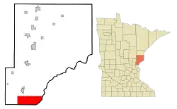 Location of the city of Rock Creek within Pine County, Minnesota | |
| Coordinates: 45°45′29″N 92°55′46″W | |
| Country | United States |
| State | Minnesota |
| County | Pine |
| Incorporated | November 4, 1970[1] |
| Government | |
| • Mayor | Craig Saari[2] |
| Area | |
| • Total | 43.32 sq mi (112.20 km2) |
| • Land | 43.01 sq mi (111.40 km2) |
| • Water | 0.31 sq mi (0.80 km2) |
| Elevation | 938 ft (286 m) |
| Population | |
| • Total | 1,628 |
| • Estimate (2019)[5] | 1,652 |
| • Density | 38.41/sq mi (14.83/km2) |
| • Demonym | Rock Creekite |
| Time zone | UTC-6 (Central (CST)) |
| • Summer (DST) | UTC-5 (CDT) |
| ZIP code | 55067 |
| Area code(s) | 320 |
| FIPS code | 27-54934[6] |
| GNIS feature ID | 0650185[7] |
| Website | http://cityofrockcreekmn.com/ |
Interstate 35 and Minnesota State Highway 70 are two of the main routes in the community. Rock Creek is mostly a rural area, made up of farm lands.
Geography
According to the United States Census Bureau, the city has a total area of 43.32 square miles (112.20 km2), of which 43.01 square miles (111.40 km2) is land and 0.31 square miles (0.80 km2) is water.[9] It is by far the largest city by area in Pine County.
Demographics
| Historical population | |||
|---|---|---|---|
| Census | Pop. | %± | |
| 1980 | 890 | — | |
| 1990 | 1,040 | 16.9% | |
| 2000 | 1,119 | 7.6% | |
| 2010 | 1,628 | 45.5% | |
| 2019 (est.) | 1,652 | [5] | 1.5% |
| U.S. Decennial Census[10] | |||
2010 census
As of the census[4] of 2010, there were 1,628 people, 582 households, and 441 families living in the city. The population density was 37.9 inhabitants per square mile (14.6/km2). There were 635 housing units at an average density of 14.8 per square mile (5.7/km2). The racial makeup of the city was 97.0% White, 0.4% African American, 0.7% Native American, 0.6% Asian, 0.1% from other races, and 1.2% from two or more races. Hispanic or Latino of any race were 1.1% of the population.
There were 582 households, of which 36.3% had children under the age of 18 living with them, 61.9% were married couples living together, 7.0% had a female householder with no husband present, 6.9% had a male householder with no wife present, and 24.2% were non-families. 17.2% of all households were made up of individuals, and 5.2% had someone living alone who was 65 years of age or older. The average household size was 2.76 and the average family size was 3.05.
The median age in the city was 39.1 years. 25.6% of residents were under the age of 18; 7.1% were between the ages of 18 and 24; 26.1% were from 25 to 44; 30.4% were from 45 to 64; and 10.7% were 65 years of age or older. The gender makeup of the city was 52.6% male and 47.4% female.
2000 census
As of the census[6] of 2000, there were 1,119 people, 389 households, and 301 families living in the city. The population density was 26.0 people per square mile (10.1/km2). There were 417 housing units at an average density of 9.7 per square mile (3.7/km2). The racial makeup of the city was 98.30% White, 0.09% African American, 0.80% Native American, 0.45% Asian, and 0.36% from two or more races. Hispanic or Latino of any race were 0.45% of the population.
There were 389 households, out of which 37.8% had children under the age of 18 living with them, 66.3% were married couples living together, 6.7% had a female householder with no husband present, and 22.4% were non-families. 15.7% of all households were made up of individuals, and 5.4% had someone living alone who was 65 years of age or older. The average household size was 2.88 and the average family size was 3.24.
In the city, the population was spread out, with 30.5% under the age of 18, 7.0% from 18 to 24, 28.4% from 25 to 44, 24.2% from 45 to 64, and 9.9% who were 65 years of age or older. The median age was 36 years. For every 100 females, there were 109.9 males. For every 100 females age 18 and over, there were 109.1 males.
The median income for a household in the city was $45,000, and the median income for a family was $48,482. Males had a median income of $33,523 versus $20,391 for females. The per capita income for the city was $17,281. About 6.8% of families and 11.5% of the population were below the poverty line, including 13.2% of those under age 18 and 12.9% of those age 65 or over.
References
- http://www.lakesnwoods.com/RockCreek.htm
- http://www.co.pine.mn.us/index.asp?Type=B_BASIC&SEC=%7B4BE2F27C-B77C-4F0A-9BE6-BFAFD400FEBF%7D
- "2019 U.S. Gazetteer Files". United States Census Bureau. Retrieved July 26, 2020.
- "U.S. Census website". United States Census Bureau. Retrieved 2012-11-13.
- "Population and Housing Unit Estimates". United States Census Bureau. May 24, 2020. Retrieved May 27, 2020.
- "U.S. Census website". United States Census Bureau. Retrieved 2008-01-31.
- "US Board on Geographic Names". United States Geological Survey. 2007-10-25. Retrieved 2008-01-31.
- "2010 Census Redistricting Data (Public Law 94-171) Summary File". American FactFinder. U.S. Census Bureau, 2010 Census. Retrieved 23 April 2011.
- "US Gazetteer files 2010". United States Census Bureau. Archived from the original on 2012-01-25. Retrieved 2012-11-13.
- "Census of Population and Housing". Census.gov. Retrieved June 4, 2015.
Municipalities and communities of Pine County, Minnesota, United States | ||
|---|---|---|
| Cities | 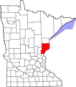 Map of Minnesota highlighting Pine County | |
| Townships | ||
| Unincorporated communities | ||
| Ghost towns | ||
| Indian reservation | ||
| ||