Rumdoodle Peak
Rumdoodle Peak, elevation 875 m ASL, is a small but prominent mountain in the north-western part of the North Masson Range in Antarctica, near Mawson Station.
| Rumdoodle Peak | |
|---|---|
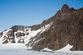 Rumdoodle Peak with the small green hut visible at the base | |
| Highest point | |
| Elevation | 875 m (2,871 ft) |
| Coordinates | 67°46′17.1″S 62°49′48.7″E |
| Geography | |
| Location | Mac. Robertson Land Antarctica |
| Parent range | North Masson Range |
Rumdoodle Skiway | |||||||||||
|---|---|---|---|---|---|---|---|---|---|---|---|
| Summary | |||||||||||
| Airport type | Private | ||||||||||
| Location | Mawson Station | ||||||||||
| Time zone | (+5) | ||||||||||
| Elevation AMSL | 1,605 ft / 489 m | ||||||||||
| Coordinates | 67°44′58″S 62°45′56″E | ||||||||||
| Map | |||||||||||
 Rumdoodle Skiway Location of airfield in Antarctica | |||||||||||
| Runways | |||||||||||
| |||||||||||
It was named, around 1960, after the previously fictitious peak featured in the book The Ascent of Rum Doodle.
There is a small hut at the base (altitude 498m ASL), sleeping 5 people, and two permanently frozen lakes alongside, named Rumdoodle Lake and Lassitude Lake.
See also
References
- "Rumdoodle Skiway". Airport Nav Finder. Retrieved October 17, 2018.
External links
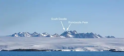
The North Masson range viewed from offshore, with Mawson Station visible in the foreground
| General |
| .svg.png.webp) |
|---|---|---|
| Regions | ||
| Waterways | ||
| Famous explorers | ||
This article is issued from Wikipedia. The text is licensed under Creative Commons - Attribution - Sharealike. Additional terms may apply for the media files.
