São Vicente (Lisbon)
São Vicente (Portuguese pronunciation: [sɐ̃w̃ viˈsẽtɨ]) is a freguesia (civil parish) and district of Lisbon, the capital of Portugal. Located in the historic center of Lisbon, São Vicente is to the east of Santa Maria Maior, south of Arroios, and west of Penha de França. São Vicente is home to numerous historic neighborhoods, including Alfama. The population in 2011 was 15,339.[1]
São Vicente | |
|---|---|
_(cropped1).jpg.webp) .JPG.webp) .jpg.webp) 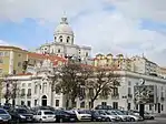 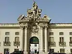 Clockwise: View of São Vicente de Fora Monastery and the National Pantheon of Santa Engrácia in the Alfama neighborhood; Graça Convent; Military Museum of Lisbon; view of Alfama; Barbacena Palace. | |
_localiza%C3%A7%C3%A3o.svg.png.webp) | |
| Coordinates: 38.719°N 9.126°W | |
| Country | |
| Region | Lisboa |
| Metropolitan area | Lisbon |
| District | Lisbon |
| Municipality | Lisbon |
| Area | |
| • Total | 1.99 km2 (0.77 sq mi) |
| Population (2011) | |
| • Total | 15,339 |
| • Density | 7,700/km2 (20,000/sq mi) |
| Time zone | UTC±00:00 (WET) |
| • Summer (DST) | UTC+01:00 (WEST) |
History
This new parish was created with the 2012 Administrative Reform of Lisbon, merging the former parishes of São Vicente de Fora, Graça and Santa Engrácia.[2]
Landmarks
References
- Instituto Nacional de Estatística (INE), Census 2011 results according to the 2013 administrative division of Portugal
- "List of the new parishes of Lisbon" (pdf). Diário de Noticias newspaper (in Portuguese). Retrieved 27 October 2013.
Freguesias (Civil Parishes) of Lisbon | ||
|---|---|---|
This article is issued from Wikipedia. The text is licensed under Creative Commons - Attribution - Sharealike. Additional terms may apply for the media files.