Quebec Route 158
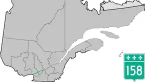
Route 158 is an east-west arterial road running between Lachute and Berthierville, north of the Ottawa and Saint Lawrence rivers, in the Laurentides region.
| ||||
|---|---|---|---|---|
 | ||||
| Route information | ||||
| Maintained by Transports Québec | ||||
| Length | 122.0 km[1] (75.8 mi) | |||
| Major junctions | ||||
| West end | ||||
| East end | Saint-Ignace-de-Loyola | |||
| Location | ||||
| Major cities | Lachute, Saint-Jérôme, Joliette | |||
| Highway system | ||||
| ||||

It runs parallel to Autoroute 50 from Lachute to Autoroute 15 near Mirabel Airport, also passing through Joliette. A section of the 158 in Joliette is a four-lane short freeway and was intended to be part of an eastern extension of A-50 towards A-40 in Berthierville by-passing several accident-prone sections of Highway 158.
In Berthierville, it junctions with Autoroute 40 and Route 138 and ends on the island municipality of Saint-Ignace-de-Loyola at the Saint Lawrence River, which can be crossed by car ferry to Route 132 in Sorel-Tracy.
Municipalities along Route 158

Quebec Route 158 in October 2014
See also
References
- Ministère des transports, "Distances routières", page 72, Les Publications du Québec, 2005
This article is issued from Wikipedia. The text is licensed under Creative Commons - Attribution - Sharealike. Additional terms may apply for the media files.