Salyes
The Salyes or Salluvii (Greek: Σάλυες) were an ancient Celto-Ligurian people dwelling between the Durance river and the Greek colony of Massalia during the Iron Age. Although earlier writers called them 'Ligurian', Strabo used the denomination 'Celto-ligurian', and a Celtic influence is noticeable in their religion, which centred on the cult of the tête coupée ('severed head').[1] In fact, the Salyes were most likely at the head of a political and military confederation that united both Gallic and Ligurian tribes.[2][3][4]
During most of the early history, the Salyes were in conflict with the neighbouring Greek inhabitants of Massalia, and later on with their ally the Roman Republic, until the consul Gaius Sextius Calvinus sacked their hill-fort Entremont in ca. 122 BC. Revolts against the Roman conquerors were crushed in 90 and 83 BC.
Name
They are mentioned as Sallyas by Caesar (mid-1st c. BC),[5] Salluvii and Saluum (var. Saluium, Salluuiorum) by Livy (late 1st c. BC),[6] Sálluas (Σάλλυας), Sállues ( Σάλλυες) and Salúōn (Σαλύων) by Strabo (early 1st c. AD),[7] Sallui and Salluuiorum by Pliny (1st c. AD),[8] Sálues (Σάλυες; var. Σάλικες) by Ptolemy (2nd c. AD),[9] and as Salyes by Avienus (4th c. AD).[10][11]
The origin of the name remains obscure. The oldest form was probably Salyes (Salues), later Latinized as Salluvii (Salluuii).[12][13] According to Patrizia de Bernardo Stempel, Salues may be a Celtic rendering of an original *Sḷwes, meaning 'the own ones'.[13] It has also been compared with the Italic personal names Salluvius, Sallubius, Salluius, and Sallyius.[14]
Geography
Territory
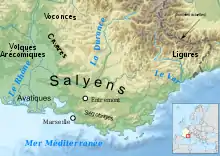
The Salyes dwelled in the hinterland of Massalia, south of the Durance river. Their homeland was located north of the Avatici, Tricores and Segobrigii, south of the Dexivates, west of the Tritolli, and east of the Anatilli.[15]
As for the stretch of country which begins at Antipolis and extends as far as Massilia or a little farther, the tribe of the Sallyes inhabits the Alps that lie above the seaboard and also—promiscuously with the Greeks—certain parts of the same seaboard.
The Salluvian confederation, which probably emerged in the 2nd century BC, covered a much larger area stretching from the Rhône to the Loup river (just west of the Var), and reaching the Mediterranean sea on the south, between the Arecomici, the Cavari and the later province of Alpes Maritimae.[12][3][16]
Settlements
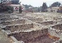
Their pre-Roman chief town was the oppidum of Entremont (3 km north of modern Aix-en-Provence). It displays Greek influence in its sculpture, its defences, and the layout of its streets.[1] However, the religious monuments and iconography were overwhelmingly native. The settlement developed relatively late during the 3rd and 2nd centuries BC, but was able to control the east-west routes connecting the Rhône to the Alps, and the north-south routes between Massalia and the Durance.[17] Entremont was taken ca. 122 BC by the Roman consul Gaius Sextius Calvinus, who founded a garrison near some warm spring in its vicinity.[18] Refounded by Caesar as a colonia latina, it was made a full colony known as Colonia Iulia Augusta Aquis Sextiis under Augustus (27 BC–14 AD).[19]
Another settlement was known as Glanon (Latin Glanum, near modern St-Rémy-de-Provence). The Gaulish Glanon means 'the clear/transparent one'; it probably took its name from a nearby river.[20][21] Located on the great trade route connecting the Iberian Peninsula to Italy and occupied since 6th–5th centuries BC,[22] Glanon came under Greek influence from the mid-2nd century BC, which has been interpreted either as a takeover by the Massaliotes or as a Greek cultural imprint on the local Salluvian aristocracy.[23][24] Glanon may have become the chief town of the Salyes after the sack of Entremont by the Romans ca. 122 BC. Major construction programs were launched between ca. 120 and 90 BC, including sanctuaries, public squares and administrative buildings, presumably for Glanon to assert itself and display its new status.[24] The settlement was abandoned ca. 270 AD after suffering from raids by Germanic tribes, and a new walled town was built in its vicinity at the site of St-Rémy.[23]
The oppidum of Baou Roux was located between Entremont and Massalia.[17]
History
Early history
The Salyes settled in the hinterland of Massalia at the latest in the 6th century BC.[1] According to a legend recounted by Livy, they fought against the Phocaean settlers at the time of the foundation of Massalia ca. 600, but were defeated by the roving armies of Bellovesus.[25] During the 5th century BC, the Salyes remained a small tribal group, although they controlled an important trading route through the valley of the Arc. By the time of the Second Punic War (218–201 BC), they also controlled areas as far south as the coastal mountains near Massalia.[3]
These were the first of the Transalpine Celti that the Romans conquered, though they did so only after carrying on war with both them and the Ligures for a long time—because the latter had barred all the passes leading to Iberia that ran through the seaboard. And, in fact, they kept making raids both by land and sea, and were so powerful that the road was scarcely practicable even for great armies. And it was not until the eightieth year of the war that the Romans succeeded, though only with difficulty, in opening up the road for a breadth of only twelve stadia to those travelling on public business.
Conflicts between Rome and the Salyes lasted during nearly eighty years from the end of the Second Punic War (201 BC), during which the eastern part of Iberia came under Roman control and Massalia remained a faithful ally of Rome, until the rendition of the Salluvian chief town Entremont ca. 122 BC.[26] Involved in piracy and raids, the Ligurians threatened throughout the 2nd century BC the Massaliotes colonies along the Mediterranean coast, and more generally the trading route between the Iberian Peninsula and Italy, culminating in 154 BC in a Roman military intervention against the Deciates and Oxybii, two Ligurian tribes that were presumably part of the Salluvian confederation.[27]
Roman conquest
In 125 BC, the Salyes waged war on Massalia, leading the Roman Senate to send the consul Marcus Fulvius Flaccus to Massalia's assistance.[28] The establishment of a Greek colony at Glanum, on Salluvian territory, may have been the casus belli.[29] Flaccus defeated the Salyes, along with the Vocontii and some other Ligurian tribes presumably part of the Salluvian confederation on the eastern borders of the Massaliote territory, then celebrated his triumph in Rome in 123 BC. Shortly after, another consul, Gaius Sextius Calvinus, sacked their chief town, Entremont, and established near its ruin a Roman garrison post, thereafter to be known as Aquae Sextiae. Sextius also forced the Salyes to withdraw from the coast, and part of their territory was granted to the Massaliotes.[28][30][31]
During the conflict, the leaders of the Salyes, including their king Toutomotulos (or Teutomalius), fled along with the rest of their armies to their allies the Allobroges, who refused to hand them over to Rome.[32][26] A further and larger force, including war elephants, was sent under the command of Gnaeus Domitius Ahenobarbus, who defeated the Allobroges at the Battle of Vindalium in 121 BC. In August of the same year, the Roman army, strengthened by the troops of Quintus Fabius Maximus, inflicted a decisive defeat on a massive combined force of Allobroges, Arveni and the remaining Salyes at the Battle of the Isère River.[32] Toutomotulus' followers were killed, enslaved, or driven into exile, while Crato, the Salluvian leader of the pro-Graeco-Roman faction, was granted 900 of his fellow citizens from slavery.[33]
Between 120 and 117, the territory of the Salyes was incorporated into the Roman province of Gallia Transalpina.[30]
Early Roman period
During the Cimbrian War, the Battle of Aquae Sextiae took place in their territory in 102 BC.[31] In 90 BC, the consul Gaius Coelius Caldus, suppressed a revolt of the Salyes.[34][30] Another revolt was crushed in 83 BC.[1]
After the foundation of a colonia romana at Arelate (Arles) in 46 BC, a large area west of Aquae Sextiae (Aix), including much of the Salluvian lands that had been handed over to Massalia ca. 122 BC, became subject to Arelate.[35]
Culture
Ethnic identity
Strabo implies that the 'Ligurian' (Λίγυας) Salyes who were mentioned by earlier writers occupied the hinterland of Massalia, whereas the later 'Celto-Ligurian' (Κελτολίγυας) Salyes also controlled the area between the Rhône and the Luberon.[36]
... though the early writers of the Greeks call the Sallyes 'Ligues', and the country which the Massiliotes hold, 'Ligustica', later writers name them 'Celtoligues', and attach to their territory all the level country as far as Luerio and the Rhodanus, the country from which the inhabitants, divided into ten parts, used to send forth an army, not only of infantry, but of cavalry as well.
In fact, the area surrounding the Salluvian chief-town of Entremont (near modern Aix-en-Provence) represented the frontier between the Ligurian tribes dwelling along the Mediterranean coast and the Celtic tribes of the lower Rhône Valley, who displayed a common force against the Roman conqueror at the end of the 2nd century BC. This geo-cultural partition was probably used by the Romans when tracing the border between the civitates of Arelate (Arles) and Aquae Sextiae (Aix) in the 1st century BC.[37]
The Celtic names of Salluvian rulers (Toutomotulos) and towns (Glanon) suggest that Celtic speakers formed the ruling class of the confederation, which developed links with neighbouring Gallic tribes like the Allobroges, although literary sources point towards a more complex reality, with significant Greek and Ligurian influences.[3][4] According to historian Guy Barruol, the confederation of the Salyes included at its height the Anatilii, Libii, Nearchi, Avatici, Dexivates, Segobrigii, Comani, Tricores, Tritolli, Camactulici, Suelteri, Oxybii, Ligauni, Deciates and Reii.[2][38] The ties that united those various tribes were probably loose, and individual oppida must have retained considerable autonomy, as evidenced by the short lapse of time during which the confederacy dissolved when the Romans destroyed the Salluvian chief town and leaders in 122–121 BC.[17]
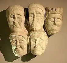
Religion
The religion of the Salyes centred on the cult of the tête coupée ('severed head'). The main shrines were located as Roquepertuse and Entremont.[1] The cult persisted at Entremont until the sack of the settlement by the Romans ca. 122 BC.[39]
A Celtic-Ligurian sanctuary dedicated to the god Glan and the Matres was found at Glanon near a mineral spring.[40]
References
- Rivet & Drinkwater 2016.
- Barruol 1969, pp. 187–188.
- Dyson 1985, pp. 136–137.
- de Hoz 2005, p. 182.
- Caesar. Commentarii de Bello Gallico, 1:35.
- Livius. Ab Urbe Condita Libri, 5:34, 21:26.
- Strabo. Geōgraphiká, 4:1:3, 4:1:5, 4:1:6, 4:1:9, 4:1:11, 4:1:12, 4:6:3–4
- Pliny. Naturalis Historia, 3:36, 3:47, 3:124.
- Ptolemy. Geōgraphikḕ Hyphḗgēsis, 2:10:8.
- Avienus. Ora maritima, 701.
- Falileyev 2010, s.v. Salluvii and Salyes.
- Barruol 1969, p. 206.
- de Bernardo Stempel 2006, p. 46.
- de Hoz 2005, p. 181.
- Talbert 2000, Map 15: Arelate-Massalia, Map 16: Col. Forum Iulii-Albingaunum.
- Verdin 1998, pp. 33–34.
- Dyson 1985, p. 138.
- Rivet 1988, pp. 39–40, 212.
- Drinkwater, John F. (2015). "Aquae Sextiae". Oxford Research Encyclopedia of Classics. doi:10.1093/acrefore/9780199381135.013.631.
- Lambert 1994, p. 37.
- Delamarre 2003, p. 180.
- Roth-Congès 1997, p. 159.
- Rivet 1988, pp. 42, 198.
- Collin Bouffier 2009, p. 49.
- Livius, Ab Urbe condita 5.34–35.
- Pralon 1998, p. 22.
- Rivet 1988, p. 32.
- Rivet 1988, pp. 39–40.
- Rivet 1988, p. 42.
- Collin Bouffier 2009, pp. 51–52.
- Rawlings 2017.
- Rivet 1988, pp. 40–41.
- Dyson 1985, p. 150.
- Rivet 1988, p. 55.
- Rivet 1988, p. 196.
- Verdin 1998, p. 33.
- Verdin 1998, p. 35.
- Rivet 1988, p. 16.
- Dyson 1985, p. 137.
- Lafond 2006.
Primary sources
- Caesar (1917). The Gallic War. Loeb Classical Library. Translated by Edwards, H. J. Harvard University Press. ISBN 978-0-674-99080-7.
- Livy (2019). History of Rome. Loeb Classical Library. Translated by Yardley, J. C. Harvard University Press. ISBN 978-0674992566.
- Pliny (1938). Natural History. Loeb Classical Library. Translated by Rackham, H. Harvard University Press. ISBN 9780674993648.
- Strabo (1923). Geography. Loeb Classical Library. Translated by Jones, Horace L. Harvard University Press. ISBN 978-0674990562.
Bibliography
- Barruol, Guy (1969). Les Peuples préromains du Sud-Est de la Gaule: étude de géographie historique. E. de Boccard. OCLC 3279201.
- Collin Bouffier, Sophie (2009). "Marseille et la Gaule Méditerranéenne avant la Conquête Romaine". In Cabouret, Bernadette (ed.). Rome et l'occident: du IIe s. av. J.-C au IIe s. apr. J.-C. Presses Universitaire du Mirail. pp. 35–60. ISBN 978-2-8107-0052-3. JSTOR 43606588.
- de Bernardo Stempel, Patrizia (2006). "From Ligury to Spain: Unaccented *yo > (y)e in Narbonensic votives ('gaulish' DEKANTEM), Hispanic coins ('iberian' -(sk)en) and some theonyms". Palaeohispanica. 6: 45–58. ISSN 1578-5386.
- de Hoz, Javier (2005). "Ptolemy and the linguistic history of the Narbonensis". In de Hoz, Javier; Luján, Eugenio R.; Sims-Williams, Patrick (eds.). New approaches to Celtic place-names in Ptolemy’s Geography. Ediciones Clásicas. pp. 173–188. ISBN 978-8478825721.
- Delamarre, Xavier (2003). Dictionnaire de la langue gauloise: Une approche linguistique du vieux-celtique continental. Errance. ISBN 9782877723695.
- Dyson, Stephen L. (1985). The Creation of the Roman Frontier. Princeton University Press. ISBN 978-1-4008-5489-9.
- Falileyev, Alexander (2010). Dictionary of Continental Celtic Place-names: A Celtic Companion to the Barrington Atlas of the Greek and Roman World. CMCS. ISBN 978-0955718236.
- Lambert, Pierre-Yves (1994). La langue gauloise: description linguistique, commentaire d'inscriptions choisies. Errance. ISBN 978-2-87772-089-2.
- Olshausen, Eckart; Sauer, Vera (2006). "Salluvii". Brill’s New Pauly. doi:10.1163/1574-9347_bnp_e1028380.
- Pralon, Didier (1998). "Les Salyens dans les textes historiques grecs". Documents d'Archéologie Méridionale. 21 (1): 21–26. doi:10.3406/dam.1998.1177.
- Rawlings, Louis (2017). "The Roman Conquest of Southern Gaul, 125-121 BC". In Whitby, Michael; Sidebottom, Harry (eds.). The Encyclopedia of Ancient Battles. John Wiley & Sons. pp. 1–7. doi:10.1002/9781119099000.wbabat0450. ISBN 978-1-4051-8645-2.
- Rivet, A. L. F. (1988). Gallia Narbonensis: With a Chapter on Alpes Maritimae : Southern France in Roman Times. Batsford. ISBN 978-0-7134-5860-2.
- Rivet, A. L. F.; Drinkwater, John F. (2016). "Salluvii". Oxford Research Encyclopedia of Classics. doi:10.1093/acrefore/9780199381135.013.5677. Cite journal requires
|journal=(help) - Roth-Congès, Anne (1997). "La fortune éphémère de Glanum : du religieux à l'économique (à propos d'un article récent)". Gallia. 54 (1): 157–202. doi:10.3406/galia.1997.2996.
- Talbert, Richard J. A. (2000). Barrington Atlas of the Greek and Roman World. Princeton University Press. ISBN 978-0691031699.
- Verdin, Florence (1998). "Les Salyens : faciès culturels et populations". Documents d'Archéologie Méridionale. 21 (1): 27–36. doi:10.3406/dam.1998.1178.
Further reading
- Lafond, Yves (2006). "Glanum". Brill’s New Pauly. doi:10.1163/1574-9347_bnp_e424670.
- Roman, Yves (1991). "L'intervention romaine de 154 av. J.-C. en Gaule transalpine : essai d'analyse". Revue archéologique de Narbonnaise. 24 (1): 35–38. doi:10.3406/ran.1991.1378.
- Verdin, Florence (1990). Les Salyens et leur territoire présumé (PhD thesis). Université de Provence.