Sanaag
Sanaag (Somali: Sanaag, Arabic: سَنَاج ) is an administrative region (gobol) in eastern Somaliland.[2] Sanaag has a long coastline facing the Gulf of Aden to the north, and is bordered by the region of Sahil to the west, Sool to the south and Somalia to the east. Its capital city is Erigavo.
Sanaag
| |
|---|---|
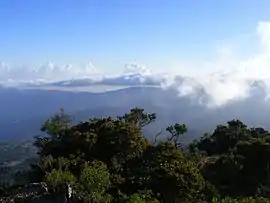 Overview of the Cal Madow mountains in Sanaag | |
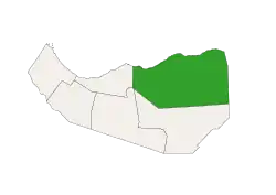 Location in Somaliland | |
| Coordinates: | |
| Country | |
| Capital | Erigavo |
| Government | |
| • Governor | Ahmed Osman Hassan Elmi |
| Time zone | UTC+3 (EAT) |
| HDI (2017) | 0.429[1] low · 2nd |
History
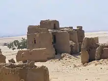
The Sanaag region and Somaliland in general is home to numerous archaeological sites, with rock art, ancient ruins, buildings and cairns found at numerous sites like Gudmo Biyo Cas, Heis, Maydh, Haylan, Qa'ableh, Qombo'ul, Gelweita and El Ayo to name a few.[3] However, many of these old structures have yet to be properly explored, a process which would help shed further light on local history and facilitate their preservation for posterity.[4]
Geography
Environment
A severe drought in the region in the early part of the 21st century caused an 80% or greater loss of livestock, though two good rainy seasons in 2004–2005 helped restore the area. Over a 15-year period of analysis, from 1988–2003, there was a 52% loss of forest and a 40% loss of grassland, and a 370% increase in bare land. Soil erosion due to weather and human activities and clearing of wood and brush for such uses as charcoal and fuel are issues leading to a degradation of the environment.[5]
Economy
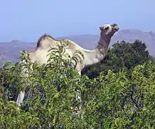
In recent history, the Sanaag region normally maintained a diverse economy, producing and then exporting to other regions, it produced livestock, frankincense, and leather for export, this was happening while the region lacked basic infrastructure, but sadly, after the outbreak of civil war the region's economy collapsed from loss of markets and dilapidated infrastructure has never helped, and lack of investment. Now the region only supports one main economy, livestock rearing. The Somali livestock ban imposed by Gulf countries in which was Sanaag's largest market has virtually destroyed the economy in the region, reducing purchasing power and forcing pastoralists in the region to survive on subsistence activities.[6]
Demographics
The region is mainly inhabited by people from the Somali ethnic group, principally the Habar Yoonis and Habar Jeclo sub-clans of the Isaaq and the Dhulbahante and Warsangali sub-divisions of the Harti Darod.[7]
Territorial dispute
Sanaag is a disputed region, claimed as sovereign territory by the republic of Somaliland and Puntland state of Somalia.
The dispute between Somaliland and Puntland stems from 1998, when Puntland formed and declared the region as part of its territory.[8] Prior to that, it had been claimed, but with no control over the region, by Somaliland since the 1991 events of the Somali Civil War. In 1994, the historic USP political party was reinstated by Awad Ahmed Asharo, former party chairman of the main Warsangeli clan. With the support of Sanaag pro-union civil society, local admin and politicians, USP was subsequently recognized by UNISOM as the legitimate representative of Sanaag.[9]
The dispute with the TFG stems from the passage of the new Charter in November 2004. However, this was not a pragmatic issue until the military successes of the government in the 2006–2007 war in Somalia. Assertions of sovereignty in January 2007 by the TFG leadership sparked riots in Somaliland for reunification with the south.[10]
On July 1, 2007, the state of Maakhir, also known as Badhan District, was declared in the area. It claimed autonomy from both Puntland and Somaliland,[11] but was eventually incorporated into Somaliland during late 2007.[12]
Districts
According to the UN, the region of Sanaag is divided into 3 districts[13] as follows:
Major towns
Minor towns
See also
References
- "Sub-national HDI - Area Database - Global Data Lab". hdi.globaldatalab.org. Retrieved 2018-09-13.
- Regions of Somalia Archived October 23, 2016, at the Wayback Machine
- Mire, Sada (2015-04-14). "Mapping the Archaeology of Somaliland: Religion, Art, Script, Time, Urbanism, Trade and Empire". African Archaeological Review. 32 (1): 111–136. doi:10.1007/s10437-015-9184-9. ISSN 0263-0338.
- Michael Hodd, East African Handbook, (Trade & Travel Publications: 1994), p.640.
- "Environmental Study of Degradation in the Sool Plateau and Gebi Valley: Sanaag Region of Northern Somalia" (PDF). Horn Relief. February 2006. Retrieved 6 February 2007.
- "Account Suspended". Archived from the original on 2016-03-05. Retrieved 2012-01-28.
- Gebrewold, Belachew (2013-03-28). Anatomy of Violence: Understanding the systems of conflict and violence in Africa. Ashgate Publishing Ltd. p. 130. ISBN 9781409499213. Retrieved 14 November 2017.
- "Remarks on the 1998 Charter of Puntland State of Somalia". Somalia Watch. 12 August 2000. Retrieved 18 January 2007.
- "USP and the means of its political weight - Historical Understanding". Somalia Watch. February 1994. Retrieved 19 February 2009.
- "Pro-government rally take place in northwest Somalia". Shabelle Media Network. 17 January 2007. Archived from the original on September 30, 2007. Retrieved 19 January 2007.
- Hirad, Abdalla (August 11, 2007). "The formation of the Maakhir State of Somalia". LaasQorayNet. Archived from the original on October 23, 2007.
- "Somaliland Takes over the Control of Badhan in Eastern Sanaag". Somalidiasporanews.com. 28 June 2013.
- "Sanaag Region" (PDF). Reliefweb.int.
External links
| Wikimedia Commons has media related to Sanaag Region. |
- Gwillim Law, "Districts of Somalia", Statoids, December 31, 1990
- SOMALIA NATIONAL PEACE CONFERENCE, "Districts of Somalia", PEACE PLAN DJIBOUTI, 20 APRIL - 5 MAY 2000
- Warsangeli Sultanate