Sandy Creek Bridge
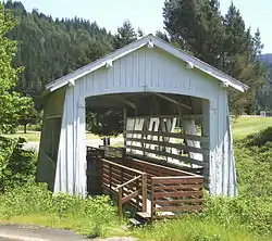
Sandy Creek Bridge is a covered bridge spanning Sandy Creek near the community of Remote in southwestern Oregon in the United States.[2] The bridge crosses the creek near its mouth on the Middle Fork Coquille River in Coos County.[3]
Sandy Creek Bridge | |
 Sandy Creek Covered Bridge Park at Remote | |
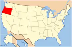
 Location of the bridge in Coos County, Oregon  Sandy Creek Bridge (the United States) | |
| Nearest city | Myrtle Point |
|---|---|
| Coordinates | 43°00′23″N 123°53′30″W |
| Built | 1921 |
| Architectural style | Howe truss |
| MPS | Oregon Covered Bridges TR[1] |
| NRHP reference No. | 79002051 |
| Listed | November 29, 1979 |
Built in 1921, the bridge carried Oregon Route 42 over the creek until bypassed by a newer bridge in 1949.[4] In 1984, after restoration by volunteers from the Lions Club of Myrtle Point, the structure became a display in a county park at the same site.[2] It is the only remaining covered bridge in Coos County.[4]
Special features of the bridge include large side openings and a truss made of two crossed Howe truss members on each chord.[4] The bridge is 60 feet (18 m) long.[4] It was added the National Register of Historic Places in 1979.[1]
See also
- List of bridges on the National Register of Historic Places in Oregon
- List of Oregon covered bridges
References
- "Sandy Creek Bridge". National Park Service. Retrieved February 3, 2016.
- "Sandy Creek (Remote) Covered Bridge" (PDF). Oregon Department of Transportation. Retrieved February 3, 2016.
- "United States Topographic Map". United States Geological Survey. Retrieved February 4, 2016 – via Acme Mapper.
- Smith, Dwight A.; Norman, James B.; Dykman, Pieter T. (1989) [1986]. Historic Highway Bridges of Oregon (2nd ed.). Portland: Oregon Historical Society Press. p. 174. ISBN 0-87595-205-4.
External links
![]() Media related to Sandy Creek Bridge (Coos County, Oregon) at Wikimedia Commons
Media related to Sandy Creek Bridge (Coos County, Oregon) at Wikimedia Commons

