National Register of Historic Places listings in Baker County, Oregon
This list presents the full set of buildings, structures, objects, sites, or districts designated on the National Register of Historic Places in Baker County, Oregon, and offers brief descriptive information about each of them. The National Register recognizes places of national, state, or local historic significance across the United States.[1] Out of over 90,000 National Register sites nationwide,[2] Oregon is home to over 2,000,[3] and 14 of those are found partially or wholly in Baker County.
- This National Park Service list is complete through NPS recent listings posted January 29, 2021.[4]
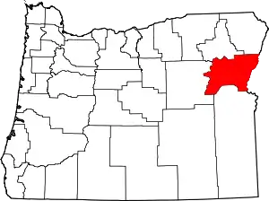
Location of Baker County in Oregon
Current listings
| [5] | Name on the Register | Image | Date listed[6] | Location | City or town | Description |
|---|---|---|---|---|---|---|
| 1 | Antlers Guard Station | 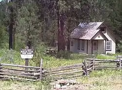 Antlers Guard Station |
March 6, 1991 (#91000166) |
Wallowa–Whitman National Forest 44°38′01″N 118°16′44″W |
Whitney vicinity | This rustic-styled cabin and garage were built for the Forest Service by the Civilian Conservation Corps around 1935. They recall both the CCC's Depression-era relief programs, and the use of architecture to express the Forest Service's identity and mission in the first half of the 20th century.[7] |
| 2 | Baker Historic District |  Baker Historic District |
December 14, 1978 (#78002277) |
Roughly along Main Street from Madison Street to Estes Street 44°46′29″N 117°49′53″W |
Baker City | |
| 3 | Baker Municipal Natatorium | _(bakDA0095a).jpg.webp) Baker Municipal Natatorium |
October 17, 1977 (#77001097) |
2470 Grove Street 44°46′53″N 117°49′31″W |
Baker City | |
| 4 | Churchill School | 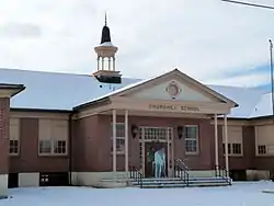 Churchill School |
March 5, 2008 (#08000182) |
3451 Broadway Street 44°46′40″N 117°50′57″W |
Baker City | |
| 5 | Robert F. and Elizabeth Clark House | 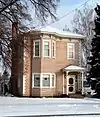 Robert F. and Elizabeth Clark House |
October 30, 1989 (#89001857) |
1522 Washington Avenue 44°46′38″N 117°49′25″W |
Baker City | |
| 6 | Cornucopia Jailhouse | 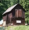 Cornucopia Jailhouse |
November 24, 2014 (#14000959) |
2nd Street 45°00′25″N 117°11′49″W |
Cornucopia | |
| 7 | James O. Maxwell Farmstead | 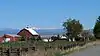 James O. Maxwell Farmstead |
November 6, 1986 (#86003086) |
15177 Muddy Creek Lane 44°56′17″N 117°59′37″W |
Haines | |
| 8 | Oregon Commercial Company Building | 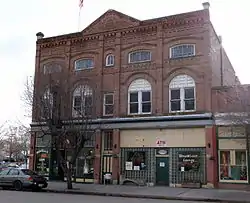 Oregon Commercial Company Building |
June 4, 1992 (#92000666) |
40-50 E. Washington Street 44°21′04″N 117°16′03″W |
Huntington | |
| 9 | Ed Rand House |  Ed Rand House |
December 9, 1981 (#81000709) |
1700 4th Street 44°46′29″N 117°50′03″W |
Baker City | |
| 10 | St. Elizabeth Hospital (Old) | 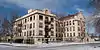 St. Elizabeth Hospital (Old) |
February 21, 1989 (#89000047) |
2365 4th Street 44°46′50″N 117°50′04″W |
Baker City | |
| 11 | Sumpter Valley Gold Dredge |  Sumpter Valley Gold Dredge |
October 26, 1971 (#71000676) |
Southwest of Sumpter near Cracker Creek 44°44′33″N 118°12′15″W |
Sumpter | Gold dredge used in placer mining along the Powder River beginning in the 1930s, representing a late, highly-mechanized phase of gold mining in Eastern Oregon.[8] |
| 12 | Sumpter Valley Railway Historic District | 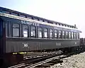 Sumpter Valley Railway Historic District |
August 3, 1987 (#87001065) |
Roughly between Baker and Prairie City starting near the McEwen station site and west to the Dixie Pass area (See also Grant County.) 44°37′13″N 118°20′07″W |
Baker City to Prairie City | |
| 13 | Superintendent's House | 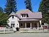 Superintendent's House |
August 20, 2004 (#04000879) |
271 S. Mill Street 44°44′39″N 118°12′08″W |
Sumpter | |
| 14 | Unity Ranger Station | 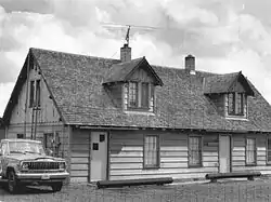 Unity Ranger Station |
April 11, 1986 (#86000823) |
Wallowa-Whitman National Forest 44°26′12″N 118°11′17″W |
Unity |
See also
- National Register of Historic Places listings in Oregon
- Listings in neighboring counties: Adams, Grant, Malheur, Wallowa, Washington, Union
- Historic preservation
- History of Oregon
- Lists of Oregon-related topics
References
- Andrus, Patrick W.; Shrimpton, Rebecca H.; et al. (2002), How to Apply the National Register Criteria for Evaluation, National Register Bulletin, National Park Service, U.S. Department of the Interior, OCLC 39493977, archived from the original on April 6, 2014, retrieved June 20, 2014.
- National Park Service, National Register of Historic Places Program: Research, archived from the original on February 1, 2015, retrieved January 28, 2015.
- Oregon Parks and Recreation Department, Oregon Historic Sites Database, retrieved August 6, 2015. Note that a simple count of National Register records in this database returns a slightly higher total than actual listings, due to duplicate records. A close reading of detailed query results is necessary to arrive at the precise count.
- "National Register of Historic Places: Weekly List Actions". National Park Service, United States Department of the Interior. Retrieved on January 29, 2021.
- Numbers represent an alphabetical ordering by significant words. Various colorings, defined here, differentiate National Historic Landmarks and historic districts from other NRHP buildings, structures, sites or objects.
- The eight-digit number below each date is the number assigned to each location in the National Register Information System database, which can be viewed by clicking the number.
- Throop, E. Gail (January 15, 1986), National Register of Historic Places Registration Form: Antlers Guard Station (PDF), retrieved January 20, 2017.
- Oregon Parks and Recreation Department. "Sumpter Valley Dredge State Heritage Area". Retrieved October 12, 2008.
External links
- Oregon Parks and Recreation Department, National Register Program
- National Park Service, National Register of Historic Places site
 Media related to National Register of Historic Places in Baker County, Oregon at Wikimedia Commons
| Lists by county | 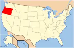 | |
|---|---|---|
| Portland lists | ||
| Other lists |
| |
| Topics | |
|---|---|
| Lists by state |
|
| Lists by insular areas | |
| Lists by associated state | |
| Other areas | |
| Related | |
| |
Municipalities and communities of Baker County, Oregon, United States | ||
|---|---|---|
| Cities | Baker County map | |
| Unincorporated communities | ||
| Ghost towns | ||
| Footnotes |
| |
| ||
This article is issued from Wikipedia. The text is licensed under Creative Commons - Attribution - Sharealike. Additional terms may apply for the media files.