Santa Fe, Texas
Santa Fe (English: Holy Faith) is a city in Galveston County, Texas. It is named for the Santa Fe Railroad (now part of BNSF Railway) which runs through the town alongside State Highway 6. The population of Santa Fe at the 2010 census was 12,222.[5] Locals refer to their town as "The Fe."
Santa Fe, Texas | |
|---|---|
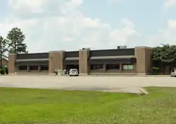 Santa Fe, Texas, Post Office | |
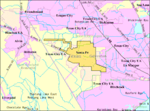
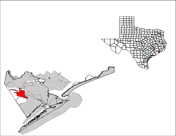 Location of Santa Fe, Texas | |
 Santa Fe Location of Santa Fe, Texas  Santa Fe Santa Fe (the United States) | |
| Coordinates: 29°22′50″N 95°6′15″W | |
| Country | |
| State | |
| County | Galveston |
| Area | |
| • Total | 17.08 sq mi (44.25 km2) |
| • Land | 16.89 sq mi (43.76 km2) |
| • Water | 0.19 sq mi (0.49 km2) |
| Elevation | 30 ft (9 m) |
| Population (2010) | |
| • Total | 12,222 |
| • Estimate (2019)[2] | 13,449 |
| • Density | 796.03/sq mi (307.34/km2) |
| Time zone | UTC-6 (Central (CST)) |
| • Summer (DST) | UTC-5 (CDT) |
| ZIP codes | 77510, 77517 |
| Area code(s) | 409 |
| FIPS code | 48-65726[3] |
| GNIS feature ID | 1351043[4] |
| Website | www |
History
In 1877, the Gulf, Colorado and Santa Fe Railway was built through the western part of Galveston county.[6] By the turn of the century, three small, unincorporated towns had formed along the railway: Alta Loma, Arcadia and Algoa. The Santa Fe Independent School District, named after the railway, was established shortly afterward to serve the area.
_%252C_Texas.jpg.webp)

In the mid-1970s, the neighboring city of Hitchcock attempted to annex an area in eastern Alta Loma known as the Morningview neighborhood. Amid intense opposition to becoming part of Hitchcock, residents began a petitioning effort to incorporate the area into a new city. On January 21, 1978, a ballot proposal to incorporate Alta Loma and parts of Arcadia passed by a wide margin and the city of Santa Fe was born. Santa Fe has since grown to include all of Arcadia and parts of Algoa, and, ironically, is now twice the size of Hitchcock.
On February 14, 1981, the Ku Klux Klan hosted a fish fry on a private farm in Santa Fe to protest the growing presence of Vietnamese shrimpers in the Gulf. During the event, a Vietnamese fishing boat was ceremonially burned.[7][8] That controversy, as well as similar conflicts in nearby port towns like Rockport, led to a decision of the United States District Court, S.D. Texas, Houston Division[9] Vietnamese Fishermen's Association v. Knights of the Ku Klux Klan,[10] and also served as the basis for the 1985 Ed Harris film Alamo Bay.

On June 19, 2000, the Supreme Court ruled that the Santa Fe Independent School District's policy of permitting "student-led, student-initiated" prayer at football games and other school events violated the Constitution's prohibitions against the establishment of state religion.[11]
On the morning of May 18, 2018, a mass shooting occurred at Santa Fe High School when 17-year-old student Dimitrios Pagourtzis opened fire in an art classroom, killing ten students and faculty and injuring thirteen others. Students and faculty evacuated the building when a fire alarm was activated. Pagourtzis surrendered after being injured in an exchange of gunfire with school officers. Originally scheduled to stand trial in January 2020 for ten counts of capital murder, Pagourtzis has been in custody at a state mental hospital since being found unfit to stand trial in November 2019.[12] [13]
Geography and Climate
Santa Fe is located at 29°22′50″N 95°6′15″W (29.380651, −95.104163) [14] on a low coastal plain that averages between 19 and 27 feet above sea level. The primary waterways are Highland Bayou and Halls Bayou, which both flow southeastward and empty into West Bay. Being prone to flash flooding, the area is lined with numerous drainage ditches, culverts, diversionary canals and reservoirs.
According to the United States Census Bureau, the city has a total area of 17.3 square miles (44.9 km2), of which 17.1 square miles (44.4 km2) is land and 0.19 square miles (0.5 km2), or 1.10%, is water.[15]
It is 35 miles (56 km) south of Downtown Houston and 20 miles (32 km) northwest of Galveston. In 2019 Skip Hollandworth of Texas Monthly wrote that Santa Fe "still feels very much like a small town" despite that distance.[16]
Santa Fe has a climate of hot, humid summers and cool, mild winters. Average annual temperature is 68.6 degrees F with 56.5 inches of annual rainfall. Santa Fe averages 71.7 days above 90 degrees F. In the Köppen Climate Classification system, Santa Fe has a humid subtropical climate, abbreviated "Cfa."
Demographics
As of the census of 2010,[3][17] there were 12,222 people and 4,564 households residing in the city. The population density was 682.5 people per square mile (275.31/km2). There were 4,957 housing units at an average density of 289.2 per square mile (111.66/km2). The racial makeup of the city was 93.8% White, 0.4% African American, 0.5% Native American, 0.5% Asian, 0.1% Pacific Islander, 3.3% from other races, and 1.5% from two or more races. Hispanic or Latino of any race were 11.6% of the population.
There were 4,583 households, out of which 36.8% had children under the age of 18 living with them, 57.7% were married couples, 12.2% had a female householder with no husband present, and 23.7% were non-families. 27.0% of all households were made up of individuals, and 19.3% had someone living alone who was 65 years of age or older. The average household size was 2.67 and the average family size was 3.03.
| Historical population | |||
|---|---|---|---|
| Census | Pop. | %± | |
| 1980 | 6,172 | — | |
| 1990 | 8,429 | 36.6% | |
| 2000 | 9,548 | 13.3% | |
| 2010 | 12,222 | 28.0% | |
| 2019 (est.) | 13,449 | [2] | 10.0% |
| U.S. Decennial Census[18] | |||
In the city, the population was spread out, with 27.2% under the age of 20, 5.2% from 20 to 24, 23.9% from 25 to 44, 29.6% from 45 to 64, and 14.3% who were 65 years of age or older. The median age was 40.5 years. For every 100 females, there were 99.6 males. For every 100 females age 18 and over, there were 97.2 males.
The median income for a household in the city was $60,797, and the median income for a family was $69,841. Males had a median income of $57,619 versus $36,445 for females. The per capita income for the city was $27,863. About 7.3% of families and 9.5% of the population were below the poverty line, including 12.3% of those under age 18 and 5.7% of those age 65 or over.
Government and infrastructure
Santa Fe City Hall is located at 12002 Highway 6. The city council consists of a mayor and five councilmembers. The Santa Fe Post Office is located at 13002 Highway 6.[19]
The Santa Fe Justice Center is located at 3650 FM 646 N.
Education
Secondary schools
Santa Fe is part of the service district for College of the Mainland, a public community college 8 miles away in Texas City. Also, Alvin Community College is 10 miles away in Alvin.
Public schools
The city is served by the Santa Fe Independent School District.
The schools in the city include:
- R.J. Wollam Elementary School (Pre-K through 2)
- Dan J. Kubacak Elementary (3 through 5; formerly Santa Fe Elementary North)
- Santa Fe Junior High School (6 through 8)
- Santa Fe High School (9 through 12)
Public libraries
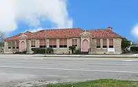
Santa Fe owns the Mae S. Bruce Library at 13302 6th Street.[20] The Santa Fe Community Library opened inside a former World War II army barracks in 1975. By 2011 the barracks became overwhelmed by the library's increasing size. A group of residents established a building committee and, with Moody Foundation and Kempner Fund grants and donations from the community, purchased a 1,920-square-foot (178 m2) metal portable building on land leased from the Santa Fe Independent School District. The portable was across Highway 6 from the barracks. After continuing growth of the library, in 1987 Mae S. Bruce presented a 6,400-square-foot (590 m2) brick structure to the city. The library moved to the structure and was renamed after Bruce.[21]
Transportation
Airports in unincorporated areas near Santa Fe include:
Airports with scheduled commercial airline service for the area, located in Houston, are William P. Hobby Airport and George Bush Intercontinental Airport. Scholes International Airport in nearby Galveston is available for general aviation and non-scheduled commercial service.
Culture
Citing Santa Fe Independent School District v. Doe, in 2019 Skip Hollandworth described Santa Fe as "a deeply conservative community."[16]
Notable residents
Country music star Johnny Lee, best known for his 1980 hit single "Lookin' for Love," was raised on a dairy farm in Santa Fe (then part of Alta Loma) and graduated from Santa Fe High School in 1964.
References
- "2019 U.S. Gazetteer Files". United States Census Bureau. Retrieved August 7, 2020.
- "Population and Housing Unit Estimates". United States Census Bureau. May 24, 2020. Retrieved May 27, 2020.
- "U.S. Census website". United States Census Bureau. Retrieved 2008-01-31.
- "US Board on Geographic Names". United States Geological Survey. 2007-10-25. Retrieved 2008-01-31.
- "Profile of General Population and Housing Characteristics: 2010 Demographic Profile Data (DP-1): Santa Fe city, Texas". United States Census Bureau. Retrieved January 9, 2012.
- SANTA FE, TX | The Handbook of Texas Online| Texas State Historical Association (TSHA)
- Claudia Kolker, San Francisco Chronicle, 11 September 2000, URL: http://www.sfgate.com:80/cgi-bin/article.cgi?file=/chronicle/archive/2000/09/11/MN95611.DTL
- Still Shrimping: Vietnamese American shrimpers 25 years after the second wave | AsianWeek
- 543 F.Supp. 198
- The KKK and Vietnamese Fishermen
- FindLaw | Cases and Codes
- "Multiple fatalities reported after Texas high school shooting - live updates". Retrieved 2018-05-18.
- Elizabeth Zwirz (2018-08-10). "Dimitrios Pagourtzis, Texas school shooting suspect, indicted on capital murder charge: report". Retrieved 2018-05-11.
- "US Gazetteer files: 2010, 2000, and 1990". United States Census Bureau. 2011-02-12. Retrieved 2011-04-23.
- "Geographic Identifiers: 2010 Demographic Profile Data (G001): Santa Fe city, Texas". United States Census Bureau. Retrieved January 9, 2012.
- Hollandsworth, Skip (May 2019). "Faith, Friendship, and Tragedy at Santa Fe High". Texas Monthly. Retrieved 2019-04-26.
- http://quickfacts.census.gov/qfd/states/48/4865726.html
- "Census of Population and Housing". Census.gov. Retrieved June 4, 2015.
- "Post Office Location – SANTA FE." United States Postal Service. Retrieved on December 6, 2008.
- "Welcome to the Mae S. Bruce Library!." Mae S. Bruce Library. Retrieved on December 6, 2011.
- "About the Mae S. Bruce Library!." Mae S. Bruce Library. Retrieved on December 6, 2008.
External links
| Wikimedia Commons has media related to Santa Fe, Texas. |
- City of Santa Fe official website
- U.S. Geological Survey Geographic Names Information System: Santa Fe, Texas
| Counties | 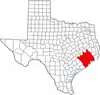 | |
|---|---|---|
| "Principal" cities | ||
| Other cities |
For a complete listing, see list of cities and towns in Houston–The Woodlands–Sugar Land MSA | |
| Unincorporated areas | ||
| Bodies of water | ||
Municipalities and communities of Galveston County, Texas, United States | ||
|---|---|---|
| Cities | 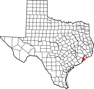 Galveston County map | |
| Village | ||
| CDPs | ||
| Other unincorporated communities | ||
| Footnotes | ‡This populated place also has portions in an adjacent county or counties | |
| ||

| Authority control |
|---|