Sary-Tash
Sary-Tash is a village[1] and major crossroads in the Alay Valley of Osh Region, Kyrgyzstan. Its population was 1,427 in 2009.[2] Nearby towns and villages to the north include Ak-Bosogo (8 km or 5 mi) and Chagyr (14 km or 9 mi).
Sary-Tash
Сарыташ | |
|---|---|
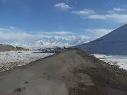 Sary Tash village with the Pamir mountains | |
 Sary-Tash | |
| Coordinates: 39°43′48″N 73°15′00″E | |
| Country | Kyrgyzstan |
| Region | Osh Region |
| District | Alay District |
| Established | 1950 |
| Elevation | 3,170 m (10,400 ft) |
| Population (2009) | |
| • Total | 1,427 |
| Time zone | UTC+6 (KGT) |
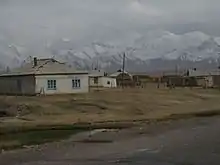
Although this remote village has only some shop-cafes, a petrol station and five guest houses (March 2016), it is an important road junction connecting China, Kyrgyzstan and Tajikistan. Its name is derived from Turkic roots and means "yellow-stone".[3]
To the north, M41 goes over the Taldyk Pass to Gulcha and Osh in the Ferghana Valley. To the south, after leaving the Alay Valley the M41 rises to the 4280m Kyzylart Pass into Tajikistan as part of the Pamir Highway. 80 kilometres (50 miles) to the east on A371 is the Irkeshtam pass to Kashgar, Xinjiang province, China. To the west, the A372 leads down the Alay Valley. The pass at the west end (towards Dushanbe, Tajikistan) is a bilateral border crossing closed to foreigners.[4]
Notes
- 2012 Law on the transformation of individual urban settlements of the Kyrgyz Republic and relating them to the category of village or city
- "2009 population census of the Kyrgyz Republic: Osh Region" (PDF). Archived from the original (PDF) on 10 August 2011. Retrieved 2011-03-22.
- Taylor, Isaac (1898). Names and their histories: a handbook of historical geography and topographical nomenclature (2nd ed.). Rivingtons. p. 317.
- "Kyrgyzstan border crossings". Caravanistan.
External links
- Satellite map at Maplandia.com
- Laurence Mitchell, Kyrgyzstan, Bradt Travel Guides, 2008