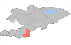
Alay District
Alay is a raion (district) of Osh Region in south-western Kyrgyzstan. The capital lies at Gul'cha.[2] The Alay District borders with China in the east, Tajikistan in the south, Chong-Alay District in the west, Nookat District in the north-west, Kara-Suu District and Uzgen District in the north, and Kara-Kulja District in the north-east. Its area is 6,821 square kilometres (2,634 sq mi), and its resident population was 72,170 in 2009.[1]
Alay | |
|---|---|
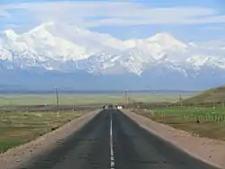 The Pamirs with Lenin Peak from Sary-Tash | |
 | |
| Country | Kyrgyzstan |
| Region | Osh Region |
| Area | |
| • Total | 6,821 km2 (2,634 sq mi) |
| Population (2009)[1] | |
| • Total | 72,170 |
| • Density | 11/km2 (27/sq mi) |
| Time zone | UTC+5 (GMT +5) |
Demographics
The resident population of Alay District, according to the Population and Housing Census of 2009, was 72,170. 1,427 people lived in urban areas, and 70,743 in rural ones.[1]
| Year | Pop. | ±% |
|---|---|---|
| 1970 | 31,851 | — |
| 1979 | 40,341 | +26.7% |
| 1989 | 52,169 | +29.3% |
| 1999 | 65,451 | +25.5% |
| 2009 | 72,170 | +10.3% |
| Note: enumerated de facto population; Source:[1] | ||
Ethnic composition
According to the 2009 Census, the ethnic composition of the Alay District (de jure population) was:[1]
| Ethnic group | Population | Proportion of Alay District population |
|---|---|---|
| Kyrgyzs | 71,901 | 99.6% |
| other groups | 269 | 0.4% |
Rural communities and villages

In total Alay District include 62 settlements in 14 rural communities (aiyl okmotus).[3][4] Each rural community can consist of one or several villages. The rural communities in Alay District are:[5]
- Sary-Tash aiyl okmotu (3: center - village: Sary-Tash; and also villages Kek-Suu and Nura)
- Alay aiyl okmotu (7: center - village: Sopu-Korgon; and also villages Askaly, Jergetal, Kolduk, Targalak, Terek and Chiy-Talaa)
- Budalyk aiyl okmotu (6: center - village: Kara-Suu; and also villages Kaynama, Tamga-Terek, Kum-Shoro, Oktyabr and Oro-Debe)
- Bulolu aiyl okmotu (4: center - village: Koshulush; and also villages Kichi-Bülölü, Köl-Chaty and Chong-Bülölü)
- Gulcho aiyl okmotu (6: center - village: Gulcha; and also villages Kara-Bulak, Jyly-Suu, Tash-Koroo, Chakmak and Kurmanjan Datka)
- Josholu aiyl okmotu (7: center - village: Jangy-Turmush; and also villages Ayuu-Tapan, Kommunizm, Lenin-Jol, Miyazdy, Orto-Suu and Osoaviakhim)
- Konur-Dobo aiyl okmotu (5: center - village: Boz-Karagan; and also villages Jar-Kyshtak, Kara-Shoro, Arpa-Tektir and Kyzyl-Oy)
- Kabylan-Kol aiyl okmotu (4: center - village: Kabylan-Kol; and also villages Kungey, Kara-Jygach and Kurulush)
- Korul aiyl okmotu (3: center - village: Toguz-Bulak; and also villages Keng-Jylga and Pervoye Maya)
- Lenin aiyl okmotu (4: center - village: Imeni Gagrina; and also villages Kun-Elek, Murdash and Sogondu)
- Sary-Mogol aiyl okmotu (1: center - village: Sary-Mogol)
- Taldy-Suu aiyl okmotu (4: center - village: Archa Bulak; and also villages Taldy-Suu, Kek-Bulak and Kurgak)
- Uch-Dobo aiyl okmoyu (6: center - village: Kichi-Karakol; and also villages Ak-Bosogo, Ak-Jay, Gejige, Kyzyl Alay and Chong-Karakol)
- Jangy-Alay aiyl okmotu (2: center - village: Jangy Alay; and also village Jangy Aryk)
References
- "2009 population census of the Kyrgyz Republic: Osh Region" (PDF). Archived from the original (PDF) on 10 August 2011. Retrieved 2011-03-22.
- Enrin.grida.no Archived 2009-08-02 at the Wayback Machine
- "State Administration of Osh Region: Alay District (in Russian)". Archived from the original on 2009-01-05. Retrieved 2010-01-22.
- 2012 Law on the transformation of individual urban settlements of the Kyrgyz Republic and relating them to the category of village or city
- "List of Rural Communities of Kyrgyzstan". Archived from the original on 2010-02-09. Retrieved 2010-01-22.
| North Kyrgyzstan |
|  Raions of Kyrgyzstan | ||||||||||
|---|---|---|---|---|---|---|---|---|---|---|---|---|
| South Kyrgyzstan |
| |||||||||||