Sarysu (river)
The Sarysu (Kazakh: Сарысу, Sarysý; Russian: Сарысу́, Sarysu) is a river in central Kazakhstan. It is 671 kilometres (417 mi) long, and has a drainage basin of 81,600 square kilometres (31,500 sq mi).[1] It arises above Atasu and flows generally westward to Kzyl-Dzhar where it turns south-westward past Birlestik and Zhanabas, then heading ever-more southerly it ends at a series of small lakes (often dry) called Telekul or Teliköl.[2][3] In former times it was a tributary of the Syr Darya, and it may still provide some subsurface flow, but the surface flow disappears more than 100 km from the Syr Darya.[4] The name sary su means yellow water in Turkic languages.
| Sarysu | |
|---|---|
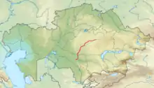 Map showing the course of the Sarysu | |
| Location | |
| Country | Kazakhstan |
| Physical characteristics | |
| Mouth | Teliköl |
• coordinates | 45°12′39″N 66°36′28″E |
| Length | 671 km (417 mi) |
| Basin size | 81,600 km2 (31,500 sq mi) |
References
- Сарысу, Great Soviet Encyclopedia
-
 . Brockhaus and Efron Encyclopedic Dictionary (in Russian). 1906.
 - Сырдарья (река), Great Soviet Encyclopedia
- Kropotkin, Peter; Bealby, John Thomas (1911). . In Chisholm, Hugh (ed.). Encyclopædia Britannica. 27 (11th ed.). Cambridge University Press. p. 419.
- Allen, W. E. D. (1956) "The Sources for G. Delisle's "Carte des Pays Voisins de la Mer Caspiene" of 1723" Imago Mundi 13: pp. 137–150, p. 139
This article is issued from Wikipedia. The text is licensed under Creative Commons - Attribution - Sharealike. Additional terms may apply for the media files.