Turgay (river)
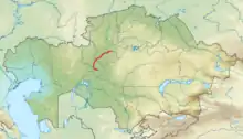
The Turgay (also Torgai, Torghay or Turgai; Kazakh: Торғай, Torghay; Russian: Тургай Turgay) is a river that flows in the Turgay Valley in Kazakhstan.[1]
| Turgay | |
|---|---|
 Location within Kazakhstan | |
| Location | |
| Country | Kazakhstan |
| Physical characteristics | |
| Mouth | Shalkarteniz desert |
• coordinates | 48°01′14″N 63°01′55″E |
| Length | 825 km (513 mi) |
| Basin size | 157,000 km2 (61,000 sq mi) |
The river is 825 km (513 mi) long, the surface of the drainage basin is 157,000 km2 (61,000 sq mi).[1] Average water discharge is around 9 cubic meters/second. The Turgay disappears in the endorheic basin of Shalkarteniz.[1]
The Turgay Plateau occupies an erosion-tectonic basin in north-western Kazakhstan, between the Urals and Mugodzhar Hills in the west and the Kazakh Steppe in the east. In the north are dry steppes with semi-steppes in the south. Deposits of iron ore and other minerals occur in the basin.[2]
The Turgay valley crosses the Turgay Plateau from south to north. The Ubagan (tributary of the Tobol) drains the valley to the north, the Turgay to the south. There are many shallow, often salty lakes in the valley.[3] This is where the Naurzumskyy reserve is located which connects the West Siberian Plain in the northern part of Kazakhstan Turan lowland.
References
