Schlieben
Schlieben (Lower Sorbian: Sliwin) is a town in the Elbe-Elster district, in southwestern Brandenburg, Germany. It is situated 22 kilometres (14 mi) north of Bad Liebenwerda. Schlieben was the site of a concentration camp during the Holocaust.[2]
Schlieben | |
|---|---|
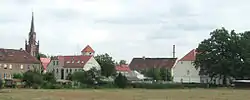 General view of Schlieben with the bell tower of historic St Martins Church | |
 Coat of arms | |
Location of Schlieben within Elbe-Elster district 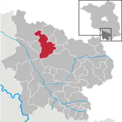 | |
 Schlieben  Schlieben | |
| Coordinates: 51°43′00″N 13°22′59″E | |
| Country | Germany |
| State | Brandenburg |
| District | Elbe-Elster |
| Municipal assoc. | Schlieben |
| Subdivisions | 6 Ortsteile |
| Government | |
| • Mayor | Helmut Richter (SPD) |
| Area | |
| • Total | 78.22 km2 (30.20 sq mi) |
| Elevation | 89 m (292 ft) |
| Population (2019-12-31)[1] | |
| • Total | 2,424 |
| • Density | 31/km2 (80/sq mi) |
| Time zone | UTC+01:00 (CET) |
| • Summer (DST) | UTC+02:00 (CEST) |
| Postal codes | 04936 |
| Dialling codes | 035361 |
| Vehicle registration | EE, FI, LIB |
| Website | www.schlieben.com |
Demography
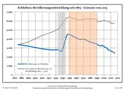
Development of Population since 1875 within the Current Boundaries (Blue Line: Population; Dotted Line: Comparison to Population Development of Brandenburg state; Grey Background: Time of Nazi rule; Red Background: Time of Communist rule)
|
|
Personalities
Sons and daughters of the city
- Ernst Legal (1881-1955), actor, director and director
Personalities connected with the city
- Edwin Zimmermann (* 1948), politician (SPD), 1990-1997 Minister for Food, Agriculture and Forestry of the State of Brandenburg
References
- "Bevölkerung im Land Brandenburg nach amtsfreien Gemeinden, Ämtern und Gemeinden 31. Dezember 2019". Amt für Statistik Berlin-Brandenburg (in German). July 2020.
- Detailed data sources are to be found in the Wikimedia Commons.Population Projection Brandenburg at Wikimedia Commons
Towns and municipalities in Elbe-Elster | ||
|---|---|---|
| Coat of Arms of Elbe-Elster district | |
This article is issued from Wikipedia. The text is licensed under Creative Commons - Attribution - Sharealike. Additional terms may apply for the media files.
