Uebigau-Wahrenbrück
Uebigau-Wahrenbrück is a town in the Elbe-Elster district, in southwestern Brandenburg, Germany. It is situated on the river Schwarze Elster, 11 km northwest of Bad Liebenwerda, and 21 km east of Torgau.
Uebigau-Wahrenbrück | |
|---|---|
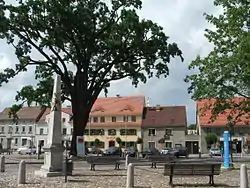 Market square in Uebigau | |
 Coat of arms | |
Location of Uebigau-Wahrenbrück within Elbe-Elster district 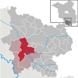 | |
 Uebigau-Wahrenbrück  Uebigau-Wahrenbrück | |
| Coordinates: 51°33′N 13°21′E | |
| Country | Germany |
| State | Brandenburg |
| District | Elbe-Elster |
| Municipal assoc. | Liebenwerda |
| Government | |
| • Mayor | Delf Gerlach |
| Area | |
| • Total | 134.91 km2 (52.09 sq mi) |
| Elevation | 84 m (276 ft) |
| Population (2019-12-31)[1] | |
| • Total | 5,206 |
| • Density | 39/km2 (100/sq mi) |
| Time zone | UTC+01:00 (CET) |
| • Summer (DST) | UTC+02:00 (CEST) |
| Postal codes | 04924, 04938 |
| Dialling codes | 035365 |
| Vehicle registration | EE, FI, LIB |
| Website | www.uebigau-wahrenbrueck.de |
Geography
The town is composed by the villages of Bahnsdorf, Beiersdorf, Beutersitz, Bomsdorf, Bönitz, Domsdorf, Drasdo, Kauxdorf, Langennaundorf, Marxdorf, München/Elster, Neudeck, Prestewitz, Rothstein, Saxdorf, Uebigau (municipal seat), Wahrenbrück, Wiederau, Wildgrube, Winkel and Zinsdorf.
Demography
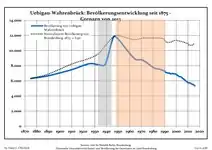 Development of Population since 1875 within the Current Boundaries (Blue Line: Population; Dotted Line: Comparison to Population Development of Brandenburg state; Grey Background: Time of Nazi rule; Red Background: Time of Communist rule)
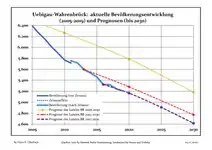 Recent Population Development and Projections (Population Development before Census 2011 (blue line); Recent Population Development according to the Census in Germany in 2011 (blue bordered line); Official projections for 2005-2030 (yellow line); for 2014-2030 (red line); for 2017-2030 (scarlet line)
|
|
|
See also
- Marxdorfer Wolfshund
Sons and daughters of the city
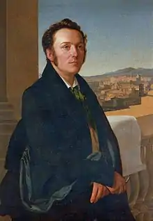
Gustav Seyffarth
- Johann Gottlieb Graun (1702–1771), composer
- Carl Heinrich Graun (1704–1759), composer
- Gustav Seyffarth (1796–1885), Egyptologist
References
- "Bevölkerung im Land Brandenburg nach amtsfreien Gemeinden, Ämtern und Gemeinden 31. Dezember 2019". Amt für Statistik Berlin-Brandenburg (in German). July 2020.
- Detailed data sources are to be found in the Wikimedia Commons.Population Projection Brandenburg at Wikimedia Commons
External links
![]() Media related to Uebigau-Wahrenbrück at Wikimedia Commons
Media related to Uebigau-Wahrenbrück at Wikimedia Commons
Towns and municipalities in Elbe-Elster | ||
|---|---|---|
| Coat of Arms of Elbe-Elster district | |
| Authority control |
|---|
This article is issued from Wikipedia. The text is licensed under Creative Commons - Attribution - Sharealike. Additional terms may apply for the media files.
